
Ain facts for kids
Quick facts for kids
Ain
|
|||
|---|---|---|---|

Prefecture building of the Ain department, in Bourg-en-Bresse
|
|||
|
|||

Location of Ain in France
|
|||
| Country | France | ||
| Region | Auvergne-Rhône-Alpes | ||
| Département | 4 March 1790 | ||
| Prefecture | Bourg-en-Bresse | ||
| Subprefectures | Belley, Gex, Nantua | ||
| Area | |||
| • Total | 5,762.4 km2 (2,224.9 sq mi) | ||
| Population
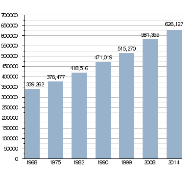
(2014)
|
|||
| • Total | 626,127 | ||
| • Density | 108.6573/km2 (281.4212/sq mi) | ||
| Time zone | UTC+1 (CET) | ||
| • Summer (DST) | UTC+2 (CEST) | ||
| ISO 3166 code | FR-01 | ||
| Arrondissements | 4 | ||
| Cantons | 23 | ||
| Communes | 410 | ||
| Website | www.ain.fr/ | ||


Ain is a special area in eastern France, like a county or province. It's called a "department." It's part of the Auvergne-Rhône-Alpes region and gets its name from the Ain River. The main city and government center is Bourg-en-Bresse.
Contents
History of the Ain Department
Ain was one of the first 83 departments created in France. This happened during the French Revolution on March 4, 1790. Bourg-en-Bresse was chosen as its capital city.
How Ain Was Formed
The department was made from five older areas called provinces. These were Bresse, Bugey, Dombes, Pays de Gex, and a small part of Franc-Lyonnais. At first, Ain was divided into nine smaller areas called districts.
Name Changes and Divisions
The department was first called "department of Bresse." But in 1791, its name was changed to "department of Ain," which it still is today. Over time, the way Ain was divided changed. In 1800, the nine districts became four larger areas called arrondissements. These were Bourg, Belley, Nantua, and Trévoux.
Later, some parts of Ain moved to other areas or came back. For example, Gex was part of another department for a while. It returned to Ain in 1814. In 1815, some towns in Gex became part of Switzerland. The arrondissement of Gex was then created.
Geography of Ain

Ain is located in the Auvergne-Rhône-Alpes region of France. It covers an area of about 5,762.4 square kilometers (2,224.9 square miles).
Where Ain is Located
The department shares borders with Switzerland to the east. It also borders six other departments in two different regions of France:
- In the Auvergne-Rhône-Alpes region:
- Haute-Savoie (to the east)
- Savoie (to the southeast)
- Isère (to the south)
- Rhône (to the southwest)
- In the Bourgogne-Franche-Comté region:
- Jura (to the north)
- Saône-et-Loire (to the northwest)
 |
Saône-et-Loire | Jura | Switzerland | |
| Haute-Savoie | ||||
| Rhône | Isère | Savoie |
Main Regions of Ain
The Ain department has five main natural areas:
- Bresse: This is a flat area, a plain, located between the Saône River and the Jura Mountains.
- Bugey-Valromey: This area is surrounded by the Rhône and Ain rivers. It's in the southern part of the Jura mountains.
- Dombes-Plain of the Ain: Found in the southeast, this area is between the Rhône and Saône rivers. It's famous for its many ponds and small lakes where fish are raised for sale.
- Pays de Gex: This region borders Switzerland to the east. It has the Bugey mountains to the west and the Jura mountains to the north. The highest point in the Jura mountains and in Ain is here: Crêt de la Neige, which is 1,720 meters (5,643 feet) high.
- Revermont: This area has two low mountain ranges running from north to south. There's a valley between them, where the Suran River flows. This region is located between Bresse and Bugey-Valromey.
The lowest point in the department is along the Rhône River, at 170 meters (558 feet) above sea level. The main rivers flowing through Ain are the Rhône, the Ain, and the Saône. The largest natural lake is Nantua lake, covering 1.41 square kilometers (0.54 square miles).
Climate in Ain
The climate in Ain, specifically in Château-Gaillard, is an "Oceanic climate". This means it has mild temperatures and rain throughout the year.
The average yearly rainfall in Château-Gaillard is 645.2 millimeters (25.40 inches). October usually has the most rain, with 63.5 millimeters (2.50 inches). February is the driest month, with an average of 43.2 millimeters (1.70 inches) of rain.
The average temperature for the year is 11.5°C (52.7°F). July is the warmest month, averaging 20.8°C (69.4°F). January is the coolest, with an average temperature of 2.6°C (36.7°F).
| Climate data for Château-Gaillard, France | |||||||||||||
|---|---|---|---|---|---|---|---|---|---|---|---|---|---|
| Month | Jan | Feb | Mar | Apr | May | Jun | Jul | Aug | Sep | Oct | Nov | Dec | Year |
| Mean daily maximum °C (°F) | 5.9 (42.6) |
7.9 (46.2) |
12.7 (54.9) |
16.1 (61.0) |
20.4 (68.7) |
24.1 (75.4) |
27 (81) |
26.6 (79.9) |
22 (72) |
16.9 (62.4) |
10.3 (50.5) |
6.5 (43.7) |
16.4 (61.5) |
| Daily mean °C (°F) | 2.6 (36.7) |
3.8 (38.8) |
7.5 (45.5) |
10.6 (51.1) |
14.9 (58.8) |
18.2 (64.8) |
20.8 (69.4) |
20.3 (68.5) |
16.5 (61.7) |
12.5 (54.5) |
6.7 (44.1) |
3.5 (38.3) |
11.5 (52.7) |
| Mean daily minimum °C (°F) | −0.8 (30.6) |
−0.3 (31.5) |
2.3 (36.1) |
5 (41) |
9.4 (48.9) |
12.3 (54.1) |
14.6 (58.3) |
14 (57) |
10.9 (51.6) |
8.1 (46.6) |
3 (37) |
0.4 (32.7) |
6.6 (43.8) |
| Average rainfall mm (inches) | 50.5 (1.99) |
42.1 (1.66) |
47.7 (1.88) |
50.9 (2.00) |
61.7 (2.43) |
56.6 (2.23) |
54.4 (2.14) |
52.2 (2.06) |
53.3 (2.10) |
63.6 (2.50) |
51.2 (2.02) |
60.6 (2.39) |
644.8 (25.4) |
| Source: Weatherbase.com [1] | |||||||||||||
Administration of Ain
The Ain department is run by the Departmental Council of Ain. This council meets in Bourg-en-Bresse. Ain is part of the larger Auvergne-Rhône-Alpes region.
Administrative Divisions
Ain is divided into several administrative parts to help manage it. These include:
- 4 arrondissements (which are like large districts)
- 23 cantons (smaller areas for elections and local services)
- 410 communes (which are like towns or municipalities)
| INSEE code |
Arrondissement | Capital | Population (2014) |
Area (km²) |
Density (Inh./km²) |
Communes |
|---|---|---|---|---|---|---|
| 011 | Belley | Belley | 98,110 | 1,394.5 | 70.4 | 115 |
| 012 | Bourg-en-Bresse | Bourg-en-Bresse | 354,177 | 3,104.8 | 114.1 | 201 |
| 013 | Gex | Gex | 89,200 | 426.2 | 209.3 | 27 |
| 014 | Nantua | Nantua | 84,640 | 837.0 | 101.1 | 65 |
Cantons of Ain
Here is a list of the 23 cantons in the Ain department. These were reorganized in March 2015.
- Ambérieu-en-Bugey (0101)
- Attignat (0102)
- Bellegarde-sur-Valserine (0103)
- Belley (0104)
- Bourg-en-Bresse-1 (0105)
- Bourg-en-Bresse-2 (0106)
- Ceyzériat (0107)
- Châtillon-sur-Chalaronne (0108)
- Gex (0109)
- Hauteville-Lompnes (0110)
- Lagnieu (0111)
- Meximieux (0112)
- Miribel (0113)
- Nantua (0114)
- Oyonnax (0115)
- Pont-d'Ain (0116)
- Replonges (0117)
- Saint-Étienne-du-Bois (0118)
- Saint-Genis-Pouilly (0119)
- Thoiry (0120)
- Trévoux (0121)
- Villars-les-Dombes (0122)
- Vonnas (0123)
People of Ain (Demographics)
There isn't one official name for all the people living in the Ain department. Instead, people are often named after the specific regions they live in:
- People from Bresse are called Bressans.
- Those from Bugey are called Bugistes.
- Residents of Revermont are Revermontois.
- People from Dombes are Dombistes.
- And those from Pays de Gex are Gessiens.
In 2014, Ain had a population of 626,127 people. This means there were about 108.7 inhabitants per square kilometer (281.5 per square mile). The arrondissement of Bourg-en-Bresse has the most people, with 354,177 residents.
Largest Towns in Ain
Here are the communes (towns) in the department that had more than 8,000 people in 2014:
| City | Population (2014) |
Arrondissement |
|---|---|---|
| Bourg-en-Bresse | 40,967 | Bourg-en-Bresse |
| Oyonnax | 22,485 | Nantua |
| Ambérieu-en-Bugey | 14,022 | Belley |
| Bellegarde-sur-Valserine | 11,745 | Nantua |
| Gex | 11,141 | Gex |
| Saint-Genis-Pouilly | 9,854 | Gex |
| Miribel | 9,425 | Bourg-en-Bresse |
| Ferney-Voltaire | 9,337 | Gex |
| Divonne-les-Bains | 9,100 | Gex |
| Belley | 8,983 | Belley |
Gallery
-
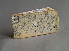
Bleu de Gex cheese
-
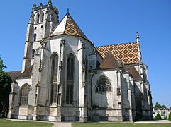
Church of Brou (Bourg-en-Bresse)
-
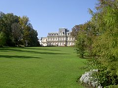
Prefecture (view from the parc)
-
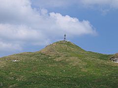
The summit of Le Reculet peak


.JPG)

Related pages
Images for kids
-
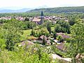
Artemare, village in the department
-
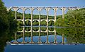
The Cize–Bolozon viaduct, a road–rail bridge crossing the Ain gorge
-
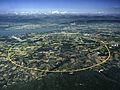
Aerial view of the Large Hadron Collider of the CERN.
-
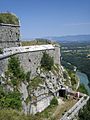
Fort l'Écluse
-
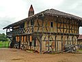
Medieval farm of Saint-Trivier-de-Courtes
-
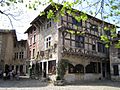
Pérouges, one of the most beautiful villages of France
-
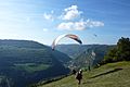
Paragliding in Ain


See also
 In Spanish: Ain para niños
