
Crêt de la Neige facts for kids
Quick facts for kids Crêt de la Neige |
|
|---|---|

|
|
| Highest point | |
| Elevation | 1,720 m (5,640 ft) |
| Prominence | 1,267 m (4,157 ft) |
| Geography | |
|
Lua error in Module:Location_map at line 420: attempt to index field 'wikibase' (a nil value).
|
|
| Location | Ain, Auvergne-Rhône-Alpes, France |
| State/Province | FR |
| Parent range | Jura Mountains |
| Geology | |
| Age of rock | Miocene |
| Climbing | |
| Easiest route | Hiking from the Tiocan lookout |
Crêt de la Neige is a tall mountain in France. It stands about 1,720 m (5,643 ft) high. This makes it the highest point in the Jura Mountains. It is also the tallest mountain in the Ain department of France. You can find it in the Jura Mountains Regional Natural Park (which is called French: Parc naturel régional du Haut-Jura in French).
Contents
Where is Crêt de la Neige?

Crêt de la Neige is located in the Ain department of France. It sits between two towns: Lélex to the northwest and Thoiry to the southeast.
This mountain is part of the Haute Chaîne. This is the highest and most eastern part of the French Jura mountains. It is found in an area called the Pays de Gex. This area is about 17 km (11 mi) northwest of the city of Geneva.
To the east of Crêt de la Neige, you'll find the flat lands of the Pays de Gex. To the west, there is the Valserine valley. This valley was formed by the Valserine river flowing through the Jura mountains.
Amazing Views from the Top
From the top of Crêt de la Neige, you can see many amazing things. Even though the very top has some shrubs and trees, the views are still incredible. You can look down and see Geneva and the Pays de Gex.
There is a full 360-degree view. This means you can see all around you! You might spot Lake Geneva, the Valserine valley, and La Dôle. La Dôle is another peak in the Jura mountains, located in Switzerland. You can also see the famous Alps mountains. On a very clear day, you might even see the Vosges mountains and the Black Forest.
How Tall is Crêt de la Neige?
For a long time, people thought Crêt de la Neige was 1,717.6 m (5,635 ft) tall. This height was shown on old maps. It was thought to be only a tiny bit taller than a nearby peak called Reculet, which was measured at 1,717.4 m (5,635 ft).
However, new studies have been done by a group called the Institut géographique national (IGN). They found that the true altitude of Crêt de la Neige is actually 1,720 m (5,643 ft) above sea level. So, it's a bit taller than we first thought!
How to Get There
The easiest way to reach the top of Crêt de la Neige is by Hiking. You can start your hike from the Tiocan lookout point. This lookout is located beyond the town of Thoiry.
Gallery
-
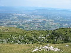
Looking towards Geneva from the summit of Cret de la Neige
-
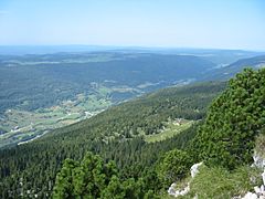
Looking towards Lélex from just below Crêt de la Neige summit (1717.6m)
-
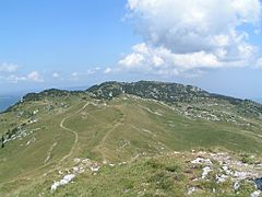
Crêt de la Neige viewed from the summit of Le Reculet
-
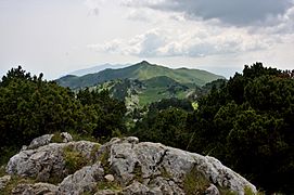
Le Reculet from the Crêt de la Neige


See also
 In Spanish: Crêt de la Neige para niños
