
Nantua facts for kids
Quick facts for kids
Nantua
|
||
|---|---|---|

Aerial view of Nantua and the lake of Nantua
|
||
|
||

Nantua
Location in France

Nantua
Location in Auvergne-Rhône-Alpes
|
||
| Country | France | |
| Region | Auvergne-Rhône-Alpes | |
| Department | Ain | |
| Arrondissement | Nantua | |
| Canton | Nantua | |
| Intercommunality | Communauté de communes du Haut Bugey | |
| Area
1
|
12.79 km2 (4.94 sq mi) | |
| Population
(2014)
|
3,534 | |
| • Density | 276.31/km2 (715.6/sq mi) | |
| Demonym(s) | Nantuatiens | |
| Time zone | UTC+01:00 (CET) | |
| • Summer (DST) | UTC+02:00 (CEST) | |
| INSEE/Postal code |
01269 /01130
|
|
| Elevation | 427–1,125 m (1,401–3,691 ft) (avg. 776 m or 2,546 ft) |
|
| Website | nantua-ville.fr | |
| 1 French Land Register data, which excludes lakes, ponds, glaciers > 1 km2 (0.386 sq mi or 247 acres) and river estuaries. | ||
.svg)
Nantua is a small town in the Ain department of France. It is located in the Auvergne-Rhône-Alpes region, which is in the eastern part of the country. Nantua is also the main town, or capital, of its local area called an arrondissement.
Contents
Exploring Nantua's Location
Nantua covers an area of about 12.8 square kilometers (around 5 square miles). The town is located in a valley, and its average height above sea level is 776 meters (about 2,546 feet). The town hall, which is the main government building, sits at an altitude of 478 meters (about 1,568 feet).
Nantua is quite far from some of France's biggest cities:
- Paris, the capital of France, is about 480 kilometers (298 miles) away.
- Lyon, the capital of the region, is much closer at 90 kilometers (56 miles).
- Other major cities like Marseille (403 km or 250 mi) and Strasbourg (460 km or 286 mi) are also a good distance away.

Nantua is surrounded by several other small towns. To the north, you'll find Apremont. To the west is Port, and to the east are Les Neyrolles and Charix.
 |
Montréal-la-Cluse | Apremont | Charix | |
| Port | Les Neyrolles | |||
| Saint-Martin-du-Frêne | Brénod |
Nantua's Climate
The climate in Nantua is known as an Oceanic climate. This means it has mild summers and no dry season. It's often described as a "Cfb" climate in the Köppen climate classification system.
Nantua's People
The people who live in Nantua are called Nantuatiens if they are men, and Nantuatiennes if they are women.
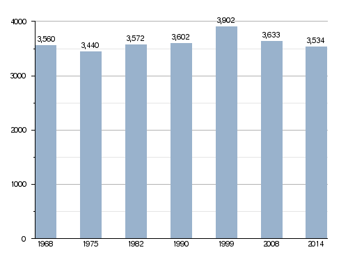
In 2014, Nantua had a population of 3,534 people. This means that for every square kilometer, there were about 276 people living there. This is called the population density.
Evolution of the population in Nantua
How Nantua is Governed
Nantua is an important administrative center. It is a subprefecture of the Ain department. This means it's a key city for local government services. It is also the capital of the arrondissement of Nantua.
The town is also the capital of the Canton of Nantua. A canton is a group of several towns, and the Canton of Nantua includes 18 different towns. In 2014, about 21,477 people lived in this canton. Nantua is also part of a larger group of towns called Haut Bugey, which work together on common projects.
The current mayor of Nantua is Jean-Pierre Carminati. He has been the mayor since 2014.
Nantua's Sister City
Nantua has a special friendship with another town. This is called being "twinned" or a "sister city." Nantua is twinned with:
 Brembilla, a town in Italy. They became sister cities in 2011.
Images for kids
-
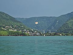
Nantua with its beautiful lake, the town, and a large bridge (viaduc).
-
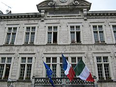
The town hall of Nantua, where local government decisions are made.
-
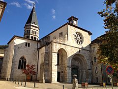
The historic Saint-Michel church in Nantua.
.JPG)


Related pages
See also
 In Spanish: Nantua para niños
