
Haute-Savoie facts for kids
Quick facts for kids
Upper Savoy
Haute-Savoie
|
|||
|---|---|---|---|

Prefecture building of the Haute-Savoie department, in Annecy
|
|||
|
|||

Location of Haute-Savoie in France
|
|||
| Country | France | ||
| Region | Auvergne-Rhône-Alpes | ||
| Département | 1860 | ||
| Prefecture | Annecy | ||
| Subprefectures | Bonneville, Saint-Julien-en-Genevois, Thonon-les-Bains | ||
| Area | |||
| • Total | 4,387.8 km2 (1,694.1 sq mi) | ||
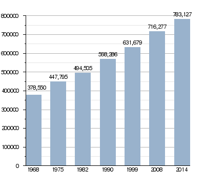
| Population
(2014)
|
|||
| • Total | 783,127 | ||
| • Density | 178.4783/km2 (462.257/sq mi) | ||
| Demonym(s) | Haut-Savoyards | ||
| Time zone | UTC+1 (CET) | ||
| • Summer (DST) | UTC+2 (CEST) | ||
| ISO 3166 code | FR-74 | ||
| Arrondissements | 4 | ||
| Cantons | 17 | ||
| Communes | 281 | ||
| Website | www.hautesavoie.fr | ||


Haute-Savoie is a special area in southeastern France. It's called a département. It's part of the Auvergne-Rhône-Alpes region. This area shares borders with both Switzerland and Italy.
Contents
What's in a Name? The Story of Haute-Savoie
Before 1860, the land that is now Haute-Savoie and the nearby Savoie department was part of the Kingdom of Sardinia. This kingdom was ruled by a Duke since 1713.
In 1860, France took control of this region. The French Emperor Napoléon III then split the land into two parts. The southern part became the Savoie department, with the city of Chambéry. The northern part became Haute-Savoie, with its main city, Annecy.
The word Haute means "High" in French. But in this case, it doesn't mean the land is high up in altitude. Instead, it means it's the "upper" or "northern" part of the original Savoie territory.
A Quick Look at History
The Haute-Savoie department was officially created in 1860. It was formed from the northern part of the old Duchy of Sardinia. When it was first made, it had four main areas called arrondissements: Annecy, Bonneville, Saint-Julien, and Thonon. Annecy was chosen as the main city, or capital.
Later, in 1926, the Saint-Julien arrondissement was removed. But it was brought back in 1933.
During World War II, from November 1942 to September 1943, the department was taken over by fascist Italy.
Exploring the Geography of Haute-Savoie
Haute-Savoie is located in the Auvergne-Rhône-Alpes region of France. It covers an area of about 4,387.8 km2 (1,694 sq mi).
The department shares its borders with two other French departments: Ain and Savoie. Both of these are also in the Auvergne-Rhône-Alpes region. On its other sides, Haute-Savoie borders the countries of Switzerland and Italy.
 |
Switzerland | Switzerland | Switzerland | |
| Ain | Switzerland | |||
| Savoie | Savoie | Italy |
A famous part of the department is the Mont Blanc massif. This huge mountain range is on the border with Italy. The average altitude of the department is around 1,160 m (3,810 ft). The very highest point in the department, and in all of France and Western Europe, is Mont Blanc. It stands tall at 4,810 m (15,781 ft)!
The rivers in Haute-Savoie flow into the Rhône river. Even though the rivers are short, the department has two important lakes. One is Lake Geneva, which it shares with Switzerland. The other is the beautiful Lake Annecy.
Climate and Weather
The climate in Annecy, the main city, is known as an "Oceanic climate". This means it has mild temperatures and rainfall throughout the year. It's also called a Maritime Temperate climate.
How Haute-Savoie is Governed
Haute-Savoie is managed by a group called the Departmental Council of Haute-Savoie. This council is based in Annecy. The department is part of the larger Auvergne-Rhône-Alpes region.
Local Divisions: Arrondissements, Cantons, and Communes
Haute-Savoie is divided into smaller administrative areas. There are 4 arrondissements (which are like districts). These are further divided into 17 cantons. Finally, there are 281 communes, which are like local towns or municipalities.
| INSEE code |
Arrondissement | Capital | Population (2014) |
Area (km²) |
Density (Inh./km²) |
Communes |
|---|---|---|---|---|---|---|
| 741 | Annecy | Annecy | 276,382 | 1,261.6 | 219.1 | 80 |
| 742 | Bonneville | Bonneville | 184,093 | 1,558.2 | 118.1 | 61 |
| 743 | Saint-Julien-en-Genevois | Saint-Julien-en-Genevois | 180,562 | 660.3 | 273.5 | 72 |
| 744 | Thonon-les-Bains | Thonon-les-Bains | 142,090 | 907.7 | 156.5 | 68 |
Here is a list of the 17 cantons in Haute-Savoie. These were reorganized in March 2015:
- Annecy-1 (7401)
- Annecy-2 (7402)
- Annecy-le-Vieux (7403)
- Annemasse (7404)
- Bonneville (7405)
- Cluses (7406)
- Évian-les-Bains (7407)
- Faverges (7408)
- Gaillard (7409)
- Le Mont-Blanc (7410)
- La Roche-sur-Foron (7411)
- Rumilly (7412)
- Saint-Julien-en-Genevois (7413)
- Sallanches (7414)
- Sciez (7415)
- Seynod (7416)
- Thonon-les-Bains (7417)
People of Haute-Savoie
The people who live in Haute-Savoie are called Haut-Savoyards in French. If you're talking about women, you'd say Haut-Savoyardes.
In 2014, Haute-Savoie had a population of 783,127 people. This means there were about 178.5 inhabitants for every square kilometer. The arrondissement of Annecy had the most people, with 276,382 residents.
How the Population of Haute-Savoie Has Changed
Here are the communes (towns or cities) in the department with the most people:
| City | Population (2014) |
Arrondissement |
|---|---|---|
| Annecy | 53,285 | Annecy |
| Thonon-les-Bains | 34,973 | Thonon-les-Bains |
| Annemasse | 34,953 | Saint-Julien-en-Genevois |
| Seynod | 20,955 | Annecy |
| Annecy-le-Vieux | 20,469 | Annecy |
| Cluses | 17,510 | Bonneville |
| Cran-Gevrier | 17,257 | Annecy |
| Sallanches | 15,754 | Bonneville |
| Rumilly | 14,836 | Annecy |
| Saint-Julien-en-Genevois | 13,253 | Saint-Julien-en-Genevois |
Gallery of Places
-
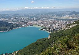
Annecy and Lake Annecy.
-
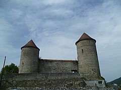
Bonneville castle.
-
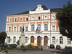
The city hall of Saint-Julien-en-Genevois.
-
Thonon-les-Bains - fishermen town.
-
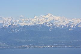
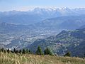
Thonon-les-Bains and the Mont-Blanc.


Related Pages
Images for kids
-
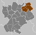
Haute-Savoie highlighted in brown in the former Rhône-Alpes region, with arrondissements outlined
-
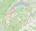
Map of Haute-Savoie
-
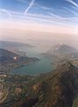
Aerial view of Annecy Lake from the southeast
-
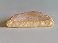
Reblochon cheese
-
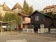
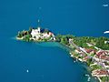
Yvoire and the Lake Léman
-
Arve Valley and the town of Cluses
-
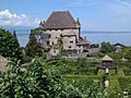
Chateau de Ruphy in Duingt
-
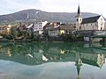
Seyssel
-
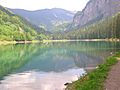
Montriond Lake
-
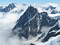
Aiguille du Midi


See also
 In Spanish: Alta Saboya para niños
