
Haute-Loire facts for kids
Quick facts for kids
Haute-Loire
|
|||
|---|---|---|---|
|
|||

Location of Haute-Loire in France
|
|||
| Country | France | ||
| Region | Auvergne-Rhône-Alpes | ||
| Département | 4 March 1790 | ||
| Prefecture | Le Puy-en-Velay | ||
| Subprefectures | Brioude, Yssingeaux | ||
| Area | |||
| • Total | 4,977.1 km2 (1,921.7 sq mi) | ||
| Population
(2014)
|
|||
| • Total | 226,565 | ||
| • Density | 45.5215/km2 (117.9001/sq mi) | ||
| Demonym(s) | Altiligériens | ||
| Time zone | UTC+1 (CET) | ||
| • Summer (DST) | UTC+2 (CEST) | ||
| ISO 3166 code | FR-43 | ||
| Arrondissements | 3 | ||
| Cantons | 19 | ||
| Communes | 257 | ||
| Website | www.hauteloire.fr | ||


Haute-Loire (which means "Upper Loire" in French) is a special area in France, like a county or a state. It is called a "département". It is located in the south-central part of the country, within the Auvergne-Rhône-Alpes region. Its name comes from the Loire River, which flows through it.
Contents
History of Haute-Loire
How Haute-Loire Was Formed
The area known as Haute-Loire became a department on March 4, 1790. It was first divided into three main parts, called districts: Le Puy, Brioude, and Yssingeaux. The main city, or capital, was Le Puy, which is now known as Le Puy-en-Velay. This new department was created from parts of three older, historic regions of France: Languedoc, Auvergne, and Lyonnais.
Changes Over Time
In 1800, the way France was organized changed. The old districts were replaced by new areas called arrondissements. So, Le Puy, Brioude, and Yssingeaux became arrondissements.
Later, in 1926, the Yssingeaux arrondissement was temporarily removed. However, it was brought back in 1942. In 1988, the capital city's name was officially changed from Le Puy to Le Puy-en-Velay.
Geography of Haute-Loire
Location and Size
Haute-Loire is part of the Auvergne-Rhône-Alpes region in France. It covers an area of about 4,977 square kilometers (about 1,922 square miles).
Neighboring Areas
The department is surrounded by five other departments. These departments are in two different regions:
- In the Auvergne-Rhône-Alpes region:
- Loire (to the north)
- Puy-de-Dôme (to the north)
- Ardèche (to the east)
- Cantal (to the west)
- In the Occitanie region:
- Lozère (to the south)
 |
Puy-de-Dôme | Loire | |
|
| Cantal | Ardèche | |||
| Lozère | Lozère |
Mountains and Rivers
The highest point in Haute-Loire is a mountain called Mont Mézenc. It stands at 1,753 meters (about 5,751 feet) tall. This mountain is located in the southeast part of the department, right on the border with the Ardèche department.
Two important rivers flow through Haute-Loire:
- The Loire River: This river flows through the eastern part of the department. It eventually reaches the Atlantic Ocean. Its water collection area covers a large part of eastern Haute-Loire.
- The Allier River: This river is a smaller stream that flows into the Loire. It runs through the western part of the department.
Climate in Haute-Loire
The climate in Le Puy-en-Velay, the capital, is an "Oceanic climate". This means it has mild temperatures and rainfall throughout the year, similar to coastal areas. It is also known as a Maritime Temperate climate.
Government and Administration
How Haute-Loire is Governed
Haute-Loire is managed by a group called the Departmental Council of Haute-Loire. This council makes decisions for the department. Its main office is in Le Puy-en-Velay. The department is part of the larger Auvergne-Rhône-Alpes region.
Divisions of the Department
Haute-Loire is divided into smaller administrative areas to help manage it. There are:
- 3 arrondissements (which are like large districts)
- 19 cantons (smaller administrative areas)
- 257 communes (which are like towns or municipalities)
Here is a table showing the arrondissements of Haute-Loire:
| INSEE code |
Arrondissement | Capital | Population (2014) |
Area (km²) |
Density (Inh./km²) |
Communes |
|---|---|---|---|---|---|---|
| 431 | Brioude | Brioude | 45,848 | 1,886.8 | 24.3 | 111 |
| 432 | Le Puy-en-Velay | Le Puy-en-Velay | 96,041 | 1,930.7 | 49.7 | 102 |
| 433 | Yssingeaux | Yssingeaux | 84,676 | 1,159.7 | 73.0 | 44 |
Here are the 19 cantons of the Haute-Loire department, which were reorganized in March 2015:
- Aurec-sur-Loire (4301)
- Bas-en-Basset (4302)
- Boutières (4303)
- Brioude (4304)
- Deux Rivières et Vallées (4305)
- Emblavez-et-Meygal (4306)
- Gorges de l'Allier-Gévaudan (4307)
- Mézenc (4308)
- Monistrol-sur-Loire (4309)
- Pays de Lafayette (4310)
- Plateau du Haut-Velay granitique (4311)
- Le Puy-en-Velay-1 (4312)
- Le Puy-en-Velay-2 (4313)
- Le Puy-en-Velay-3 (4314)
- Le Puy-en-Velay-4 (4315)
- Saint-Paulien (4316)
- Sainte-Florine (4317)
- Velay volcanique (4318)
- Yssingeaux (4319)
People of Haute-Loire
Population and Demographics
The people who live in Haute-Loire are called Altiligériens (for men) or Altiligériennes (for women) in French.
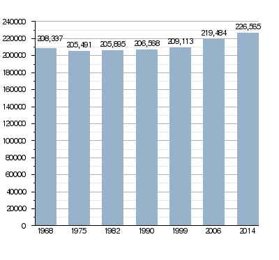
In 2014, Haute-Loire had a population of 226,565 people. This means there were about 45.5 people living in each square kilometer. The arrondissement of Le Puy-en-Velay had the most people, with 96,041 residents.
How the population of Haute-Loire has changed over time
Main Towns and Cities
Here are the towns and cities in Haute-Loire with the largest populations:
| City | Population (2014) |
Arrondissement |
|---|---|---|
| Le Puy-en-Velay | 18,634 | Le Puy-en-Velay |
| Monistrol-sur-Loire | 8,808 | Yssingeaux |
| Yssingeaux | 7,105 | Yssingeaux |
| Brioude | 6,700 | Brioude |
| Aurec-sur-Loire | 6,035 | Yssingeaux |
| Sainte-Sigolène | 5,952 | Yssingeaux |
| Bas-en-Basset | 4,314 | Yssingeaux |
| Brives-Charensac | 4,153 | Le Puy-en-Velay |
| Saint-Just-Malmon | 4,153 | Yssingeaux |
| Langeac | 3,758 | Brioude |
Images for kids
-
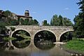
Lavaudieu
-
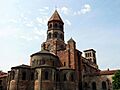
Brioude
-
Lavoûte-Chilhac
-
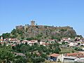
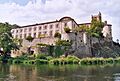
Polignac


Related pages
See also
 In Spanish: Alto Loira para niños
