
Largentière facts for kids
Quick facts for kids
Largentière
|
||
|---|---|---|

A view of Largentière.
|
||
|
||

Largentière
Location in France

Largentière
Location in Auvergne-Rhône-Alpes
|
||
| Country | France | |
| Region | Auvergne-Rhône-Alpes | |
| Department | Ardèche | |
| Arrondissement | Largentière | |
| Canton | Vallon-Pont-d'Arc | |
| Intercommunality | Val de Ligne | |
| Area
1
|
7.22 km2 (2.79 sq mi) | |
| Population
(2014)
|
1,734 | |
| • Density | 240.17/km2 (622.0/sq mi) | |
| Demonym(s) | Largentiérois | |
| Time zone | UTC+01:00 (CET) | |
| • Summer (DST) | UTC+02:00 (CEST) | |
| INSEE/Postal code |
07132 /07710
|
|
| Elevation | 147–420 m (482–1,378 ft) (avg. 284 m or 932 ft) |
|
| Website | www.largentiere.fr | |
| 1 French Land Register data, which excludes lakes, ponds, glaciers > 1 km2 (0.386 sq mi or 247 acres) and river estuaries. | ||
.svg)
Largentière (Occitan: L'Argentièira) is a small town in southeastern France. It is located in the Ardèche department, which is part of the Auvergne-Rhône-Alpes region. Largentière is also an important administrative center, known as a "subprefecture," for its area.
Contents
The Name Largentière
The name Largentière comes from the French word "argent," which means "silver." This name was first used in the 1200s. It replaced an older name, Segualeriae (Ségualières). The area was famous for its silver mines between the 900s and 1400s.
Geography of Largentière
Largentière is found in the southern part of the Ardèche department. It sits in a narrow valley next to the Ligne River. The Ligne River is a small river that flows into the larger Ardèche River.
The town covers an area of about 7.2 square kilometers (2.8 square miles). Its average height above sea level is 284 meters (932 feet). At the town hall, the height is 240 meters (787 feet).
Distances to Major Cities
Largentière is located far from many big cities in France:
- Paris, the capital of France - 647 km (402 mi) away.
- Lyon, the regional capital - 187 km (116 mi) away.
- Marseille - 218 km (135 mi) away.
- Strasbourg - 678 km (421 mi) away.
- Reims - 672 km (418 mi) away.
- Bordeaux - 631 km (392 mi) away.
- Toulouse - 393 km (244 mi) away.
- Montpellier - 155 km (96 mi) away.
- Nice - 373 km (232 mi) away.

Largentière is surrounded by several other towns:
 |
Tauriers | Chassiers | Vinezac | |
| Sanilhac | ||||
| Montréal | Uzer |
Climate
Largentière has an "Oceanic climate" (also known as Maritime Temperate climate). This means it has mild temperatures and rainfall throughout the year.
Population
The people who live in Largentière are called Largentiérois (for men) and Largentiéroises (for women) in French.
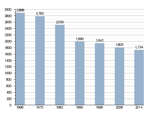
Largentière has a population of 1,734 people. This means there are about 240 inhabitants per square kilometer. It is the second smallest subprefecture in France. Only Castellane in the Alpes-de-Haute-Provence department is smaller, with 1,541 people (as of 2014).
Evolution of the population in Largentière
Administration
Largentière has been a subprefecture of the Ardèche department since 1800. This means it is an important center for local government. It is also the main town of the Largentière area and is part of the Vallon-Pont-d'Arc canton.
The town is part of a group of towns called Val de Ligne. This group works together on shared services and projects.
Gallery
-
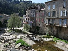
Largentière and the La Ligne river.
-
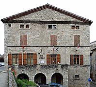
Town hall of Largentière.
-
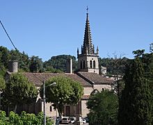
Largentière church.
-
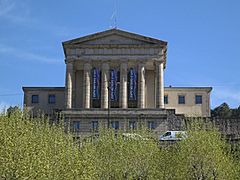
Courthouse of Largentière.
-
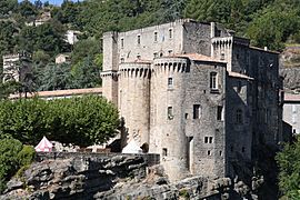
Castle of Largentière.


Related Pages
See also
 In Spanish: Largentière para niños
