
Hautes-Pyrénées facts for kids
Quick facts for kids
Hautes-Pyrénées
|
|||
|---|---|---|---|

Prefecture building of the Hautes-Pyrénées department, in Tarbes
|
|||
|
|||

Location of Hautes-Pyrénées in France
|
|||
| Country | France | ||
| Region | Occitanie | ||
| Département | 4 March 1790 | ||
| Prefecture | Tarbes | ||
| Subprefectures | Argelès-Gazost, Bagnères-de-Bigorre | ||
| Area | |||
| • Total | 4,464.0 km2 (1,723.6 sq mi) | ||
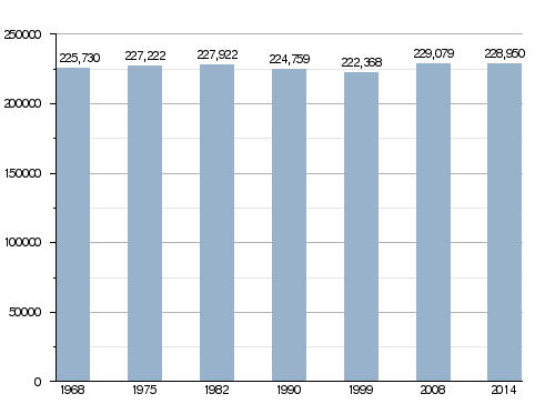
| Population
(2014)
|
|||
| • Total | 228,950 | ||
| • Density | 51.2881/km2 (132.836/sq mi) | ||
| Demonym(s) | Haut-Pyrénéens / Bigourdans | ||
| Time zone | UTC+1 (CET) | ||
| • Summer (DST) | UTC+2 (CEST) | ||
| ISO 3166 code | FR-65 | ||
| Arrondissements | 3 | ||
| Cantons | 17 | ||
| Communes | 470 | ||
| Website | www.hautespyrenees.fr | ||


Hautes-Pyrénées (which means "High Pyrenees") is a department located in the southwest of France. It is part of the Occitanie region. The main city and capital of this department is Tarbes.
Contents
History of Hautes-Pyrénées
Hautes-Pyrénées is one of the first 83 departments ever created in France. It was formed during the French Revolution on March 4, 1790. This new department was made from parts of an older area called Gascony. Specifically, it included the old province of Bigorre and the Pays des Quatre-Vallées.
Exploring the Geography of Hautes-Pyrénées
Hautes-Pyrénées covers an area of about 4,464 square kilometers (1,723 square miles). This is about 0.81% of France's total land. It is part of the Occitanie region. Interestingly, it has two small areas of land, called exclaves, that are completely surrounded by the neighboring department of Pyrénées-Atlantiques. These small areas are leftovers from the Middle Ages.
The department is surrounded by different regions and countries:
- It borders two regions in France:
- Occitanie to the north (with the Gers department) and to the east (with the Haute-Garonne department).
- Nouvelle-Aquitaine to the west (with the Pyrénées-Atlantiques department).
- To the south, it shares a border with Spain, specifically the province of Huesca.
 |
Gers | |
||
| Pyrénées-Atlantiques | Haute-Garonne | |||
| Spain |

You can see three main natural areas within the department.
The Mighty Pyrenees Mountains
The Pyrenees mountains form a natural wall between France and Spain. They cover the southern half of the department, making up 66% of its land. In this area, more than 30 mountains are taller than 3,000 meters (9,843 feet)!
The highest point in the department is Pic Vignemale. It stands at 3,299 meters (10,823 feet) high and is located right on the border with Spain. The Vignemale mountain is part of the beautiful Pyrénées National Park.
Hills and Plains
The second natural region in Hautes-Pyrénées covers about 17% of the department. This area is made up of lower hills.
The third region is in the northern part of the department. This is the flat plain of the Adour river. It is mostly used for agriculture, meaning it's great for growing crops.
Rivers of the Department
The most important river in the department is the Adour river. It flows through major cities like Tarbes and Bagnères-de-Bigorre. Other important rivers include the Gave de Pau and the Neste.
As mentioned, Hautes-Pyrénées also has two small areas of land, called exclaves, that are separated from the main department. These small pieces of land are located inside the neighboring department of Pyrénées-Atlantiques.
Climate of Hautes-Pyrénées
The department has an oceanic climate. This means it has fairly warm summers and mild winters. It also gets a lot of rain. This type of climate is known as Cfb in the Köppen climate classification system.
In Lourdes, the average rainfall for a year is about 1,005.8 millimeters (39.6 inches). November usually has the most rain, with about 109.2 millimeters (4.3 inches). July is the driest month, with only about 50.8 millimeters (2 inches) of rain on average.
The average yearly temperature in Lourdes is 11.8°C (53.2°F). July is the warmest month, averaging 18.9°C (66.0°F). January is the coolest, with an average temperature of 5°C (41°F).
| Climate data for Tarbes, France (altitude 360m, 1981–2010) (Source: Météo-France, Infoclimat.fr) | |||||||||||||
|---|---|---|---|---|---|---|---|---|---|---|---|---|---|
| Month | Jan | Feb | Mar | Apr | May | Jun | Jul | Aug | Sep | Oct | Nov | Dec | Year |
| Mean daily maximum °C (°F) | 10.3 (50.5) |
11.3 (52.3) |
14.2 (57.6) |
15.8 (60.4) |
19.5 (67.1) |
22.8 (73.0) |
25.1 (77.2) |
25.2 (77.4) |
22.8 (73.0) |
19.0 (66.2) |
13.7 (56.7) |
11.0 (51.8) |
17.6 (63.7) |
| Mean daily minimum °C (°F) | 1.0 (33.8) |
1.5 (34.7) |
3.7 (38.7) |
5.6 (42.1) |
9.5 (49.1) |
12.8 (55.0) |
14.9 (58.8) |
14.9 (58.8) |
11.9 (53.4) |
8.7 (47.7) |
4.3 (39.7) |
1.8 (35.2) |
7.6 (45.7) |
| Average precipitation mm (inches) | 95.0 (3.74) |
81.1 (3.19) |
87.0 (3.43) |
111.7 (4.40) |
111.6 (4.39) |
78.0 (3.07) |
56.0 (2.20) |
68.1 (2.68) |
71.6 (2.82) |
88.1 (3.47) |
102.5 (4.04) |
96.7 (3.81) |
1,047.4 (41.24) |
| Average precipitation days (≥ 1.0 mm) | 11 | 9 | 10 | 13 | 13 | 10 | 7 | 9 | 9 | 11 | 10 | 10 | 120 |
| Mean monthly sunshine hours | 118 | 129 | 169 | 170 | 189 | 198 | 205 | 206 | 190 | 151 | 117 | 109 | 1,951 |
| Source 1: climat.meteofrance.com | |||||||||||||
| Source 2: infoclimat.fr | |||||||||||||
How Hautes-Pyrénées is Governed
The department is managed by the Departmental Council of the Haute-Garonne. This council is based in Tarbes, the capital city. Hautes-Pyrénées is part of the larger Occitanie region.
Administrative Divisions
Hautes-Pyrénées is divided into smaller areas to help with its management.
- There are 3 arrondissements (which are like large districts).
- It has 17 cantons (smaller administrative areas).
- There are 470 communes (these are like local towns or municipalities).
| INSEE code |
Arrondissement | capital | Population (2014) |
Area (km²) |
Density (Inh./km²) |
Communes |
|---|---|---|---|---|---|---|
| 651 | Argelès-Gazost | Argelès-Gazost | 38,813 | 1,300.2 | 29.9 | 87 |
| 652 | Bagnères-de-Bigorre | Bagnères-de-Bigorre | 46,384 | 1,675.7 | 27.7 | 171 |
| 653 | Tarbes | Tarbes | 143,753 | 1,488.1 | 96.6 | 212 |
Here is a list of the 17 cantons in the Hautes-Pyrénées department. This list follows the changes made in March 2015:
- Aureilhan (6501)
- Bordères-sur-l'Échez (6502)
- Les Coteaux (6503)
- La Haute-Bigorre (6504)
- Lourdes-1 (6505)
- Lourdes-2 (6506)
- Moyen Adour (6507)
- Neste, Aure et Louron (6508)
- Ossun (6509)
- Tarbes-1 (6510)
- Tarbes-2 (6511)
- Tarbes-3 (6512)
- Val d'Adour-Rustan-Madiranais (6513)
- La Vallée de l'Arros et des Baïses (6514)
- La Vallée de la Barousse (6515)
- La Vallée des Gaves (6516)
- Vic-en-Bigorre (6517)
Population of Hautes-Pyrénées
The people who live in Hautes-Pyrénées are called Haut-Pyrénéens (for men) or Haut-Pyrénéennes (for women) in French. They are also sometimes known as Bigourdans.
In 2014, Hautes-Pyrénées had a population of 228,950 people. This means there were about 51.3 inhabitants for every square kilometer (132.9 inhabitants per square mile). The arrondissement of Tarbes is the largest, with 143,753 people. The other two, Argelès-Gazost and Bagnères-de-Bigorre, have 38,813 and 46,384 people, respectively.
The city with the most people is the capital, Tarbes, with 40,900 residents. The next largest is Lourdes with 14,361 people. The subprefectures of Argelès-Gazost and Bagnères-de-Bigorre have 3,020 and 7,602 inhabitants, respectively.
Evolution of the population in Hautes-Pyrénées

Here are the cities in the department with more than 4,000 inhabitants:
| City | Population (2014) |
Arrondissement |
|---|---|---|
| Tarbes | 40,900 | Tarbes |
| Lourdes | 14,361 | Argelès-Gazost |
| Aureilhan | 7,879 | Tarbes |
| Bagnères-de-Bigorre | 7,602 | Bagnères-de-Bigorre |
| Lannemezan | 5,912 | Bagnères-de-Bigorre |
| Vic-en-Bigorre | 5,004 | Tarbes |
| Bordères-sur-l'Échez | 4,879 | Tarbes |
| Séméac | 4,803 | Tarbes |
| Juillan | 4,104 | Tarbes |
Images for kids
-
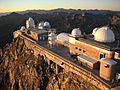
Pic du Midi de Bigorre
-
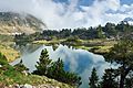
Middle of Lake Bastan, shortly before sunset
-
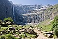
Cirque de Gavarnie


Related pages
See also
 In Spanish: Altos Pirineos para niños
