
Argelès-Gazost facts for kids
Quick facts for kids
Argelès-Gazost
|
||
|---|---|---|
|
Subprefecture and commune
|
||

Argelès-Gazost viewed from Hautacam.
|
||
|
||

Argelès-Gazost
Location in France

Argelès-Gazost
Location in Occitanie
|
||
| Country | France | |
| Region | Occitanie | |
| Department | Hautes-Pyrénées | |
| Arrondissement | Argelès-Gazost | |
| Canton | Argelès-Gazost | |
| Intercommunality | Vallée d'Argelès-Gazost | |
| Area
1
|
3.05 km2 (1.18 sq mi) | |
| Population
(2014)
|
3,020 | |
| • Density | 990/km2 (2,565/sq mi) | |
| Demonym(s) | Argelésiens | |
| Time zone | UTC+01:00 (CET) | |
| • Summer (DST) | UTC+02:00 (CEST) | |
| INSEE/Postal code |
65440 /65000
|
|
| Elevation | 412–600 m (1,352–1,969 ft) (avg. 506 m or 1,660 ft) |
|
| Website | www.argeles-gazost.fr | |
| 1 French Land Register data, which excludes lakes, ponds, glaciers > 1 km2 (0.386 sq mi or 247 acres) and river estuaries. | ||
.svg)
Argelès-Gazost is a lovely town, or commune, located in southwestern France. It is part of the Hautes-Pyrénées area, which is a department in the Occitanie region. This town is also found in the historic area called Gascony.
Argelès-Gazost is important because it is the main town, or capital, of its local district, known as an arrondissement. The people who live here are called Argelésiens in French.
Contents
History of Argelès-Gazost
How Argelès-Gazost Got Its Name
The town of Argelès-Gazost has an interesting history. It first became a commune in 1790 and was simply called Argelès.
Later, in 1824, another nearby commune called Vieuzac joined with Argelès. Vieuzac had also been a commune since 1790.
The name of the town changed again in 1896. It became Argelès-Gazost, which is the name we know today.
Geography of Argelès-Gazost
Where is Argelès-Gazost Located?
Argelès-Gazost is nestled in a beautiful natural area called Lavedan. This region is part of the amazing Pyrenees mountains.
The town is located where two rivers meet: the Gave de Pau and the Gave d'Azun. It sits right between two other well-known places, Lourdes and Gavarnie.
Size and Elevation
Argelès-Gazost covers an area of about 3.05 km2 (1 sq mi). This is roughly 1.18 square miles.
The town is quite high up! Its average height above sea level is 506 m (1,660 ft). At the town hall, the altitude is about 508 m (1,667 ft).
 |
Ayzac-Ost | Boô-Silhen | |
|
| Gez | Ayros-Arbouix | |||
| Arcizans-Avant and Arras-en-Lavedan | Lau-Balagnas |
Climate in Argelès-Gazost
The weather in Argelès-Gazost is known as an Oceanic climate with mild summers. This type of climate is often found near oceans, bringing moderate temperatures and rainfall throughout the year.
Population of Argelès-Gazost
How Many People Live Here?
In 2014, Argelès-Gazost had a population of 3,020 people. This means that about 990.2 people live in each square kilometer of the town.
Administration of Argelès-Gazost
Local Government and Districts
Since 1790, Argelès-Gazost has been a subprefecture of the Hautes-Pyrénées department. This means it's an important administrative center for the area.
It is also the main town of the arrondissement of Argelès-Gazost. An arrondissement is like a district within a department.
Argelès-Gazost is also the administrative center, or chef-lieu, for the canton of La Vallée des Gaves. This canton includes 50 different towns and had 15,743 inhabitants in 2014.
The town is part of a group of communes called La Vallée d'Argelès-Gazost. This group works together on local projects and services.
Sites of Interest in Argelès-Gazost
There are several interesting places to visit in Argelès-Gazost:
- The Saint-Saturnin church: This beautiful church was built in the second half of the 1800s.
- Château d'Ourout: This castle was first built between the 1400s and 1500s. It was rebuilt in the 1800s. The castle, its park, and its chapel are protected as historical monuments since 1995.
- Vieuzac tower: This old tower dates back to the 1300s.
- Mendaigne tower: This tower was built in the 1700s.
- Pyrénées Animal Park (Parc Animalier des Pyrénées): A great place to see animals from the Pyrenees region.
Gallery
-
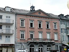
Argelès-Gazost City Hall
-
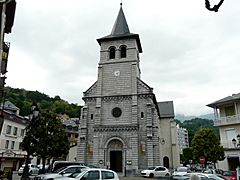
Saint-Saturnin church
-
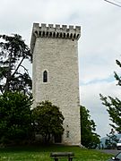
Vieuzac tower
-
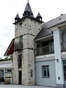
Mendaigne tower
-
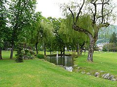
Stream of hot water in a park


.JPG)
Images for kids
-
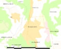
Map of the commune of Argelès-Gazost

Related pages
See also
 In Spanish: Argelès-Gazost para niños
