
Pyrénées-Atlantiques facts for kids
Quick facts for kids
Pyrénées-Atlantiques
|
||
|---|---|---|

The Chateau de Pau above the Gave de Pau
|
||
|
||

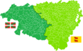
Location of Pyrénées-Atlantiques in France
|
||
| Country | France | |
| Region | Nouvelle-Aquitaine | |
| Département | 4 March 1790 | |
| Prefecture | Pau | |
| Subprefectures | Bayonne, Oloron-Sainte-Marie | |
| Area | ||
| • Total | 7,644.8 km2 (2,951.7 sq mi) | |
| Population
(2013)
|
||
| • Total | 664,057 | |
| • Rank | 36th | |
| • Density | 86.8639/km2 (224.9764/sq mi) | |
| Demonym(s) | Béarnais or Basques | |
| Time zone | UTC+1 (CET) | |
| • Summer (DST) | UTC+2 (CEST) | |
| ISO 3166 code | FR-64 | |
| Arrondissements | 3 | |
| Cantons | 27 | |
| Communes | 547 | |
| Website | http://www.le64.fr | |

Pyrénées-Atlantiques is a department in the Nouvelle-Aquitaine region of France. It gets its name from the Pyrenees mountains and the Atlantic Ocean. People who live here are called Basques or Béarnais.
Contents
History of Pyrénées-Atlantiques
Pyrénées-Atlantiques is one of the 83 French departments created during the French Revolution. This happened on March 4, 1790. It was first called Basses-Pyrénées.
The new department was made from parts of older areas. These were Guyenne, Béarn, and Gascony. It had six main areas called districts. These were Mauléon, Oloron, Orthez, Pau, Saint-Palais, and Ustaritz.
The main office, called the prefecture, moved a few times. It started in Navarrenx, then moved to Pau. In 1795, it moved to Saint-Palais. But in 1796, it went back to Pau.
On October 10, 1969, the department's name changed. It went from Basses-Pyrénées to Pyrénées-Atlantiques.
Geography and Landscape

Pyrénées-Atlantiques is in the southwest of France. It is part of the Nouvelle-Aquitaine region. This department is the 10th largest in France. Its total area is about 7,644.8 square kilometers (2,951.7 square miles).
There are two small areas within the department that belong to the nearby Hautes-Pyrénées department. These are like small islands of land. They have been there since the Middle Ages.
The department is surrounded by other areas. To the north are Landes and Gers. To the east is Hautes-Pyrénées. To the south is Spain, and to the west is the Bay of Biscay (part of the Atlantic Ocean).
Mountains and Rivers
The Pyrenees mountain range is in the southern part of the department. It stretches from east to west. It starts at the Col d'Aubisque, which is a mountain pass. This pass is about 30 kilometers (19 miles) south of Tarbes and Pau. The mountains then go all the way to the mouth of the Bidasoa river.
The highest point in the department is Pic Palas. It is 2,974 meters (9,757 feet) high. This mountain is also the highest in the Aquitaine region. It is located right on the border with Spain.
The main river in the department is the Adour. Most other rivers in the area flow into the Adour. Some important rivers include the Gaves réunis. This river is formed by the Gave d'Oloron and Gave de Pau rivers joining together. Another important river is the Nive.
Climate in Pau
The climate in Pau is a Marine West Coast Climate. This means it has mild winters and warm summers. The average temperature for the year in Pau is about 13.5°C (56.3°F).
The warmest month is usually July. The average temperature then is about 20.7°C (69.3°F). The coolest month is January, with an average temperature of 6.6°C (43.9°F).
Pau gets a lot of rain. The average rainfall for the year is about 1051.6 millimeters (41.4 inches). December usually has the most rain, with about 104.1 millimeters (4.1 inches). February is the driest month, with about 73.7 millimeters (2.9 inches) of rain.
| Climate data for Uzein (Pau), Pyrénées-Atlantiques, France | |||||||||||||
|---|---|---|---|---|---|---|---|---|---|---|---|---|---|
| Month | Jan | Feb | Mar | Apr | May | Jun | Jul | Aug | Sep | Oct | Nov | Dec | Year |
| Daily mean °C (°F) | 6.6 (43.9) |
7.4 (45.3) |
10.0 (50.0) |
11.9 (53.4) |
15.6 (60.1) |
18.7 (65.7) |
20.7 (69.3) |
20.7 (69.3) |
18.2 (64.8) |
14.7 (58.5) |
9.8 (49.6) |
7.2 (45.0) |
13.5 (56.2) |
| Average rainfall mm (inches) | 84.9 (3.34) |
74.7 (2.94) |
79.2 (3.12) |
73.1 (2.88) |
97.9 (3.85) |
88.3 (3.48) |
86.6 (3.41) |
79.1 (3.11) |
89 (3.5) |
100.4 (3.95) |
94.2 (3.71) |
103.8 (4.09) |
1,051.2 (41.38) |
| Source: Weatherbase.com [1] | |||||||||||||
How the Department is Governed
The Pyrénées-Atlantiques department is run by the General Council of the Pyrénées-Atlantiques. This council is located in Pau. The department is part of the Nouvelle-Aquitaine region.
Administrative Divisions
The Pyrénées-Atlantiques department is divided into smaller parts. It has 3 main arrondissements (districts). It also has 27 cantons and 547 communes (which are like small towns or municipalities).
| INSEE Code |
Arrondissement | Capital | Population (2013) |
Area (km²) |
Density (Inh./km²) |
Communes |
|---|---|---|---|---|---|---|
| 641 | Bayonne | Bayonne | 285,761 | 2,270 | 125.9 | 123 |
| 642 | Oloron-Sainte-Marie | Oloron-Sainte-Marie | 74,737 | 2,885 | 25.9 | 155 |
| 643 | Pau | Pau | 303,559 | 2,490 | 121.9 | 269 |
Here is a list of the 27 cantons in the Pyrénées-Atlantiques department. These were reorganized in March 2015:
- Anglet
- Artix et Pays de Soubestre
- Baïgura et Mondarrain
- Bayonne-1
- Bayonne-2
- Bayonne-3
- Biarritz
- Billère et Coteaux de Jurançon
- Le Cœur de Béarn
- Hendaye-Côte Basque-Sud
- Lescar, Gave et Terres du Pont-Long
- Montagne Basque
- Nive-Adour
- Oloron-Sainte-Marie-1
- Oloron-Sainte-Marie-2
- Orthez et Terres des Gaves et du Sel
- Ouzom, Gave et Rives du Neez
- Pau-1
- Pau-2
- Pau-3
- Pau-4
- Pays de Bidache, Amikuze et Ostibarre
- Pays de Morlaàs et du Montanérès
- Saint-Jean-de-Luz
- Terres des Luys et Coteaux du Vic-Bilh
- Ustaritz-Vallées de Nive et Nivelle
- Vallées de l'Ousse et du Lagoin
Population and Main Cities
The people living in Pyrénées-Atlantiques are called Basques et Béarnais. The Basques mostly live in the western part of the department. The Béarnais live more in the eastern part. Before 1969, when the department's name changed, people were called Bas-Pyrénéens.
In 2013, the Pyrénées-Atlantiques had a population of 664,057 people. This means there were about 86.9 people per square kilometer. The arrondissement of Pau is the largest, with 303,559 people. Bayonne has 285,761 people, and Oloron-Sainte-Marie has 74,737 people.
The biggest city in the department is its capital, Pau. It has 77,575 residents. The subprefectures are Bayonne (47,492 people) and Oloron-Sainte-Marie (10,794 people).
Here are some of the main cities in the department:

| City | Population (2013) |
Arrondissement |
|---|---|---|
| Pau | 77,575 | Pau |
| Bayonne | 47,492 | Bayonne |
| Anglet | 39,184 | Bayonne |
| Biarritz | 24,993 | Bayonne |
| Hendaye | 16,887 | Bayonne |
| Billère | 13,479 | Pau |
| Saint-Jean-de-Luz | 12,967 | Bayonne |
| Lons | 12,106 | Pau |
| Oloron-Sainte-Marie | 10,794 | Oloron-Sainte-Marie |
| Orthez | 10,569 | Pau |
Gallery
-
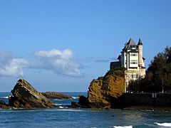
Villa Belza in Biarritz
-
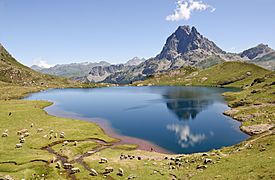
Lac Gentau
-

Château de Pau


Related pages
- Arrondissements of the Pyrénées-Atlantiques department
- Communes of the Pyrénées-Atlantiques department
Images for kids
-
French Basque Country (western side) and the Béarn (eastern side)
-

Lac Gentau


See also
 In Spanish: Pirineos Atlánticos para niños
