
Oloron-Sainte-Marie facts for kids
Quick facts for kids
Oloron-Sainte-Marie
|
||
|---|---|---|

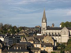
View of Oloron-Sainte-Marie
|
||
|
||

Oloron-Sainte-Marie
Location in France

Oloron-Sainte-Marie
Location in Nouvelle-Aquitaine
|
||
| Country | France | |
| Region | Nouvelle-Aquitaine | |
| Department | Pyrénées-Atlantiques | |
| Arrondissement | Oloron-Sainte-Marie | |
| Canton | Chief town of 2 cantons | |
| Intercommunality | Piémont Oloronais | |
| Area
1
|
68.31 km2 (26.37 sq mi) | |
| Population
(2013)
|
10,794 | |
| • Density | 158.015/km2 (409.26/sq mi) | |
| Demonym(s) | Oloronais | |
| Time zone | UTC+01:00 (CET) | |
| • Summer (DST) | UTC+02:00 (CEST) | |
| INSEE/Postal code |
64422 /64400
|
|
| Elevation | 194–1,380 m (636–4,528 ft) (avg. 216 m or 709 ft) |
|
| Website | www.oloron-ste-marie.fr | |
| 1 French Land Register data, which excludes lakes, ponds, glaciers > 1 km2 (0.386 sq mi or 247 acres) and river estuaries. | ||

Oloron-Sainte-Marie is a city in southwestern France. It is a commune, which is like a local town area. It is located in the Pyrénées-Atlantiques department. A department is similar to a county or a larger administrative region.
In 1858, two smaller areas called Saint-Marie-Legugnon and Oloron joined together. They formed the new commune we know today as Oloron-Sainte-Marie.
Contents
About Oloron-Sainte-Marie
Where is Oloron-Sainte-Marie?
Oloron-Sainte-Marie is at the bottom of the Pyrénées mountains. It is about 32 kilometers (20 miles) south of Pau. The city is also about 50 kilometers (31 miles) from the border with Spain. The Atlantic Ocean is about 100 kilometers (62 miles) away.
The total area of the commune is about 68.31 square kilometers (26.37 square miles). The average height above sea level, called altitude, is 787 meters (2,582 feet). At the city hall, the altitude is 216 meters (709 feet).

Rivers of Oloron
The Gave d'Oloron river flows through Oloron-Sainte-Marie. This river is formed when two other rivers meet. These are the Gave d'Aspe and the Gave d'Ossau. When rivers meet, it is called a confluence. The word gave is a special name for rivers in the western Pyrenees mountains.
People of Oloron-Sainte-Marie
About 10,794 people live in Oloron-Sainte-Marie. This means there are about 158 people living in each square kilometer. This is called the population density.
People who live in Oloron-Sainte-Marie are called Oloronais in French. If they are women, they are called Oloronaises.
How the City is Run
Oloron-Sainte-Marie has been a sous-préfecture since 1800. A sous-préfecture is a main town for a smaller part of a department. It helps manage the area. The city is also the main town for two cantons. A canton is a smaller administrative area, like a district.
Local Government Areas
- Canton of Oloron-Sainte-Marie-1: This area includes part of Oloron-Sainte-Marie and several other communes.
- Canton of Oloron-Sainte-Marie-2: This area also includes another part of Oloron-Sainte-Marie and other communes.
Gallery
-
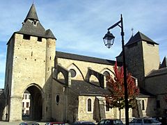
The beautiful Cathedral of Sainte Marie d'Oloron.
-
Notre Dame church.
-
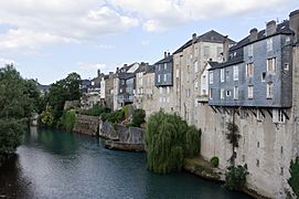
Houses built along the Gave d'Aspe river.
-
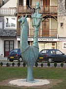
A statue of Saint Great.


Fun Facts
Oloron-Sainte-Marie is twinned with one other city. This means they are like sister cities and share culture and friendship.
Related Pages
More Pictures
-
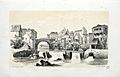
Oloron in 1843, painted by Eugène de Malbos
-
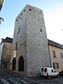
The Tour de Grède (Grède Tower)
-
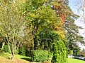
Parc Pommé, a local park
-
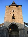
Another view of the Cathedral Sainte Marie
_-_Fonds_Ancely_-_B315556101_A_MALBOS_2_010.jpg)


See also
 In Spanish: Oloron-Sainte-Marie para niños
