
Langon, Gironde facts for kids
Quick facts for kids
Langon
|
||
|---|---|---|
|
Subprefecture and commune
|
||

Langon and the Garonne.
|
||
|
||

Langon
Location in France

Langon
Location in Nouvelle-Aquitaine
|
||
| Country | France | |
| Region | Nouvelle-Aquitaine | |
| Department | Gironde | |
| Arrondissement | Langon | |
| Canton | Le Sud-Gironde | |
| Intercommunality | Le Sud Gironde | |
| Area
1
|
13.71 km2 (5.29 sq mi) | |
| Population
(2014)
|
7,396 | |
| • Density | 539.46/km2 (1,397.2/sq mi) | |
| Demonym(s) | Langonnais | |
| Time zone | UTC+01:00 (CET) | |
| • Summer (DST) | UTC+02:00 (CEST) | |
| INSEE/Postal code |
33227 /33210
|
|
| Elevation | 0–73 m (0–240 ft) (avg. 37 m or 121 ft) |
|
| Website | www.langon33.fr | |
| 1 French Land Register data, which excludes lakes, ponds, glaciers > 1 km2 (0.386 sq mi or 247 acres) and river estuaries. | ||
.svg)
Langon (which is Lengon in the Gascon language) is a town in southwestern France. It is a commune, which is like a local government area. Langon is located in the Gironde department, which is part of the Nouvelle-Aquitaine region. It is one of the five main administrative centers, called sub-prefectures, in the department.
Contents
Exploring Langon's Location
Langon is found in the southeastern part of the Gironde department. It is about 48 kilometers (30 miles) southeast of the big city of Bordeaux. The town sits on the left side of the Garonne River. It is also close to where the Graves wine region meets the Landes forest.
The town covers an area of about 13.7 square kilometers (5.3 square miles). Its average height above sea level is 37 meters (121 feet). Right at the city hall, the height is 20 meters (66 feet).

Langon is surrounded by several other towns. To the east is Saint-Pierre-de-Mons. To the southeast is Coimères, and to the south is Mazères. Roaillan is to the southwest, Fargues is to the west, and Toulenne is to the northwest. Across the Garonne River, you will find Saint-Maixant to the north and Saint-Macaire to the northeast.
 |
Toulenne | Saint-Maixant | Saint-Macaire | |
| Fargues | Saint-Pierre-de-Mons | |||
| Roaillan | Mazères | Coimères |
Langon's Climate
Langon has a Marine West Coast Climate. This type of weather is also known as Cfb in the Köppen climate classification system. It means the town has mild winters and warm summers.
Understanding Langon's Population
The people who live in Langon are called Langonnais in French. If you are talking about women from Langon, they are called Langonnaises.
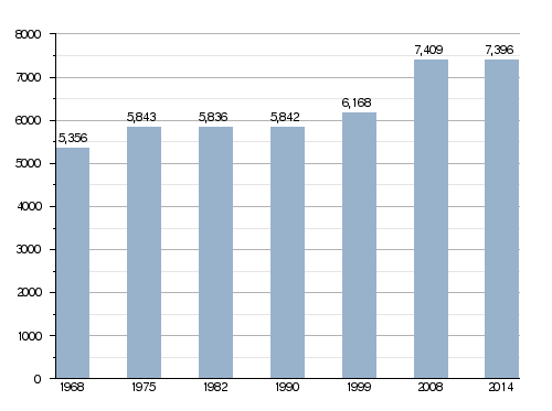
Langon has a population of 7,396 people. This means that about 539 people live in each square kilometer (1,396 people per square mile) of the town's area.
How Langon's Population Has Changed Over Time
How Langon is Governed
Langon is an important administrative center. It is a sub-prefecture for the Gironde department. This means it helps manage a larger area. It is also the main town of the arrondissement of Langon. An arrondissement is a type of district in France.
Langon is also the administrative centre (or chef-lieu in French) of the canton of Le Sud-Gironde. A canton is a smaller administrative area. This canton had 39,445 people living in it in 2014.
The town is part of a group of communes called Le Sud Gironde. This group works together on common projects. In French, this is called Communauté de communes du Sud Gironde.
Langon's Twin Towns
Langon has special friendships with other towns around the world. These are called twin towns. They often share culture and ideas. Langon is twinned with:
Gallery of Langon
-
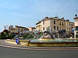
A view of downtown Langon.
-
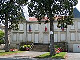
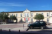
The building of the sub-prefecture.
-
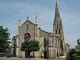
The Saint-Gervais church.
-
The Les Carmes cultural center.


Related Pages
Images for kids
-
none

See also
 In Spanish: Langon (Gironda) para niños
