
Gironde facts for kids
Quick facts for kids
Gironde
|
|||
|---|---|---|---|
.JPG)
Prefecture building of the Gironde department, in Bordeaux
|
|||
|
|||

Location of Gironde in France
|
|||
| Country | France | ||
| Region | Nouvelle-Aquitaine | ||
| Département | 4 March 1790 | ||
| Prefecture | Bordeaux | ||
| Subprefectures | Arcachon, Blaye, Langon, Lesparre-Médoc, Libourne | ||
| Area | |||
| • Total | 9,975.6 km2 (3,851.6 sq mi) | ||
| Population
(2014)
|
|||
| • Total | 1,526,016 | ||
| • Density | 152.9749/km2 (396.2031/sq mi) | ||
| Demonym(s) | Girondins | ||
| Time zone | UTC+1 (CET) | ||
| • Summer (DST) | UTC+2 (CEST) | ||
| ISO 3166 code | FR-33 | ||
| Arrondissements | 6 | ||
| Cantons | 33 | ||
| Communes | 538 | ||
| Website | www.gironde.fr | ||


Gironde (which is Gironda in Occitan language) is a special area in the southwest of France. It's called a "department." Its name comes from the Gironde estuary, which is a wide river mouth where the Dordogne and Garonne rivers meet the sea.
This department is part of the Nouvelle-Aquitaine region. Its main city, also known as its "prefecture," is Bordeaux.
Contents
History of Gironde
Gironde was created during the French Revolution on March 4, 1790. It was formed from parts of older French areas called provinces, specifically Guyenne and Gascony.
For a short time, from July 1793 to April 1795, the department's name was changed to Bec-d'Ambès. This was done to avoid being linked to a political group from the revolution called the Girondists.
The department was first divided into seven smaller areas called "districts." These were Bordeaux, Libourne, La Réole, Bazas, Cadillac, Blaye, and Lesparre. The main city, or capital, was Bordeaux.
Geography and Nature
Gironde is located in the Nouvelle-Aquitaine region in southwestern France. It's the biggest department in Metropolitan France (the part of France in Europe). It covers a huge area of about 9,975.6 square kilometers (3,851.6 square miles).
Gironde has four main types of landscapes:
- The coastal zone: This area includes part of the Côte d'Argent, which means "Silver Coast." It's a beautiful coastline along the Atlantic Ocean.
- The forest: A large forest covers the western half of the department.
- The Bordelais: This is the area around the city of Bordeaux. It's famous for producing many different kinds of delicious Bordeaux wines.
- The Bazadais: This region is around the town of Bazas in the southwest. Farming is a very important activity here.
Gironde shares its borders with several other departments: Charente-Maritime to the north, Dordogne to the east, Lot-et-Garonne to the southeast, and Landes to the south. The Atlantic Ocean (also known as the Gulf of Biscay) is to the west.
 |
Charente-Maritime | |
||
| Atlantic Ocean | Dordogne | |||
| Landes | Lot-et-Garonne |
The two most important rivers in Gironde are the Dordogne and the Garonne. These two rivers join together to form the Gironde estuary. This estuary is the largest river mouth in all of France.
Climate
The climate in Bordeaux is a Marine West Coast Climate. This type of climate is known for its mild winters and warm summers. It's often called Cfb in the Köppen climate classification system.
The average temperature in Bordeaux for the whole year is about 13.8 °C (56.8 °F). The warmest month is usually July, with an average temperature of 21.4 °C (70.5 °F). The coolest month is typically January, with an average temperature of 6.6 °C (43.9 °F).
Bordeaux gets about 850.9 millimeters (33.5 inches) of rain each year. November is usually the wettest month, with about 88.9 mm (3.5 inches) of rain. July is the driest month, with an average of only 53.3 mm (2.1 inches) of rain.
Government and Divisions
Gironde is part of the Nouvelle-Aquitaine region. It is managed by a group called the Departmental Council of Gironde, which is based in Bordeaux.
Administrative Divisions
Gironde is divided into smaller administrative areas to help manage it. There are:
- 6 arrondissements (which are like large districts)
- 33 cantons (smaller areas within arrondissements)
- 538 communes (which are like towns or municipalities)
| INSEE code |
Arrondissement | Capital | Population (2014) |
Area (km²) |
Density (Inh./km²) |
Communes |
|---|---|---|---|---|---|---|
| 331 | Blaye | Blaye | 88,115 | 782.4 | 112.6 | 63 |
| 332 | Bordeaux | Bordeaux | 921,668 | 1,521.8 | 605.6 | 82 |
| 333 | Langon | Langon | 130,911 | 2,644.3 | 49.5 | 197 |
| 334 | Lesparre-Médoc | Lesparre-Médoc | 86,560 | 2,274.4 | 38.1 | 50 |
| 335 | Libourne | Libourne | 152,602 | 1,282.9 | 119.0 | 129 |
| 336 | Arcachon | Arcachon | 146,160 | 1,469.8 | 99.4 | 17 |
Here is a list of the 33 cantons in the Gironde department. These divisions were updated in March 2015:
- Andernos-les-Bains (3301)
- Bordeaux-1 (3302)
- Bordeaux-2 (3303)
- Bordeaux-3 (3304)
- Bordeaux-4 (3305)
- Bordeaux-5 (3306)
- Le Bouscat (3307)
- La Brède (3308)
- Cenon (3309)
- Les Coteaux de Dordogne (3310)
- Créon (3311)
- L'Entre-Deux-Mers (3312)
- L'Estuaire (3313)
- Gujan-Mestras (3314)
- Les Landes des Graves (3315)
- Le Libournais-Fronsadais (3316)
- Lormont (3317)
- Mérignac-1 (3318)
- Mérignac-2 (3319)
- Le Nord-Gironde (3320)
- Le Nord-Libournais (3321)
- Le Nord-Médoc (3322)
- Pessac-1 (3323)
- Pessac-2 (3324)
- Les Portes du Médoc (3325)
- La Presqu'île (3326)
- Le Réolais et Les Bastides (3327)
- Saint-Médard-en-Jalles (3328)
- Le Sud-Gironde (3329)
- Le Sud-Médoc (3330)
- Talence (3331)
- La Teste-de-Buch (3332)
- Villenave-d'Ornon (3333)
Population and Cities
The people who live in Gironde are called Girondins (for men) or Girondines (for women) in French.
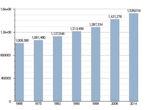
In 2014, the Gironde department had a population of 1,526,016 people. This means there were about 153 people living in every square kilometer (or 396 people per square mile). The arrondissement of Bordeaux is the largest by far, with 921,668 people. The arrondissements of Blaye and Lesparre-Médoc have fewer people, with 88,115 and 86,560 inhabitants respectively.
How the population of Gironde has changed over time
Here are some of the main cities in the Gironde department:
| City | Population (2014) |
Arrondissement |
|---|---|---|
| Bordeaux | 246,586 | Bordeaux |
| Mérignac | 69,301 | Bordeaux |
| Pessac | 61,514 | Bordeaux |
| Talence | 41,182 | Bordeaux |
| Villenave-d'Ornon | 31,027 | Bordeaux |
| Saint-Médard-en-Jalles | 29,779 | Bordeaux |
| Bègles | 26,437 | Bordeaux |
| La Teste-de-Buch | 25,990 | Arcachon |
| Gradignan | 24,841 | Bordeaux |
| Libourne | 24,595 | Libourne |
Gallery
-
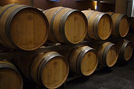
Bordeaux wine
-
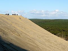
The Great Dune of Pyla
-
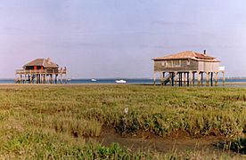
Arcachon Bay
-
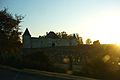
Château de la Brède, the birthplace of Montesquieu


Related pages
Images for kids
-
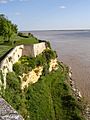
The Gironde estuary seen from the citadel of Blaye
-
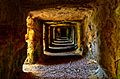
Grottoes of Ferrand
-
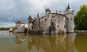
Château d'Eck


See also
 In Spanish: Gironda para niños
