Arrondissement of Libourne facts for kids
Quick facts for kids
Arrondissement of Libourne
|
|
|---|---|

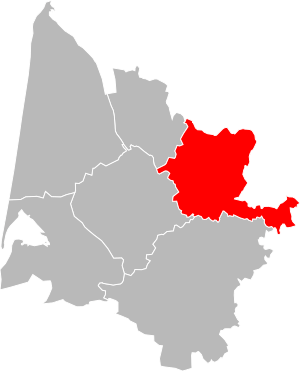
Location of Libourne in Gironde
|
|
| Country | France |
| Region | Nouvelle-Aquitaine |
| Department | Gironde |
| Communes | 129 |
| Subprefecture | Libourne |
| INSEE code | 335 |
| Area | |
| • Total | 1,282.9 km2 (495.3 sq mi) |
| Population
(2014)
|
|
| • Total | 152,602 |
| • Density | 118.951/km2 (308.081/sq mi) |
The arrondissement of Libourne is a special administrative area in France. Think of it as a district within a larger region. It belongs to the Gironde department, which is like a county, and it's located in the Nouvelle-Aquitaine region. The main city, or capital, of this arrondissement is Libourne.
Contents
History of Libourne Arrondissement
The Libourne arrondissement was created a very long time ago, on 17 February 1800. It was one of the original parts of the Gironde department when that department was first formed.
Geography of Libourne Arrondissement
The Libourne arrondissement is located in the northeast part of the Gironde department. It covers an area of about 1,282.9 square kilometers (or 495.3 square miles).
In 2014, about 152,602 people lived here. This means the area has a population density of about 119 people per square kilometer. Population density tells you how many people live in each square kilometer of land.
The arrondissement is surrounded by other areas:
- To the north, it borders the Charente-Maritime department.
- To the east, it borders the Dordogne department.
- To the southeast, it borders the Lot-et-Garonne department.
- To the south, it borders the Langon arrondissement.
- To the west, it borders the Bordeaux and Blaye arrondissements.
How Libourne Arrondissement is Organized
Arrondissements in France are divided into smaller areas called cantons and communes.
Cantons in Libourne Arrondissement
Cantons are like electoral districts. After some changes in France, the borders of cantons don't always perfectly match the borders of arrondissements. This means a canton might include small towns (called communes) that belong to different arrondissements.
In the Libourne arrondissement, most cantons are fully within its borders. However, two cantons, Le Nord-Gironde and Le Réolais et Les Bastides, have some communes that are part of other arrondissements.
Communes in Libourne Arrondissement
A commune is the smallest administrative division in France, similar to a town or a small village. The Libourne arrondissement has 129 communes in total.
Here are some of the communes in the Libourne arrondissement that have the most people living in them:
| INSEE code |
Commune | Population (2014) |
Canton | Intercommunality |
|---|---|---|---|---|
| 33243 | Libourne | 24,595 | Le Libournais-Fronsadais | Communauté d'agglomération du Libournais |
| 33138 | Coutras | 8,410 | Le Nord-Libournais | Communauté d'agglomération du Libournais |
| 33207 | Izon | 5,466 | Le Libournais-Fronsadais | Communauté d'agglomération du Libournais |
| 33393 | Saint-Denis-de-Pile | 5,277 | Le Nord-Libournais | Communauté d'agglomération du Libournais |
| 33324 | Pineuilh | 4,307 | Le Réolais et Les Bastides | Le Pays Foyen |
| 33539 | Vayres | 3,711 | Le Libournais-Fronsadais | Communauté d'agglomération du Libournais |
| 33478 | Saint-Seurin-sur-l'Isle | 3,129 | Le Nord-Libournais | Communauté d'agglomération du Libournais |
| 33179 | Galgon | 3,029 | Le Libournais-Fronsadais | Le Fronsadais |
| 33108 | Castillon-la-Bataille | 2,979 | Les Coteaux de Dordogne | Castillon – Pujols |
Related pages
See also
 In Spanish: Distrito de Libourne para niños
 | Valerie Thomas |
 | Frederick McKinley Jones |
 | George Edward Alcorn Jr. |
 | Thomas Mensah |

