
Charente-Maritime facts for kids
Quick facts for kids
Charente-Maritime
|
|||
|---|---|---|---|

Prefecture building of the Charente-Maritime department, in La Rochelle
|
|||
|
|||

Location of Charente-Maritime in France
|
|||
| Country | France | ||
| Region | Nouvelle-Aquitaine | ||
| Département | 4 March 1790 | ||
| Prefecture | La Rochelle | ||
| Subprefectures | Jonzac, Rochefort, Saintes, Saint-Jean-d'Angély | ||
| Area | |||
| • Total | 6,863.8 km2 (2,650.1 sq mi) | ||
| Population
(2014)
|
|||
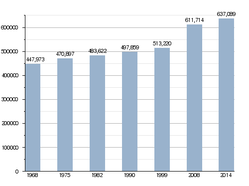
| • Total | 637,089 | ||
| • Density | 92.8187/km2 (240.3993/sq mi) | ||
| Demonym(s) | Charentais maritimes | ||
| Time zone | UTC+1 (CET) | ||
| • Summer (DST) | UTC+2 (CEST) | ||
| ISO 3166 code | FR-17 | ||
| Arrondissements | 5 | ||
| Cantons | 27 | ||
| Communes | 469 | ||
| Website | Official website: https://la.charente-maritime.fr/ | ||


Charente-Maritime (pronounced "Sha-ront Mah-ree-teem") is a special area in western France. It's called a "department," which is like a big county. It sits right on the coast of the Atlantic Ocean.
This department gets its name from the Charente River, which is very important here. The "Maritime" part tells you it's by the sea. The main city and administrative center is La Rochelle.
Contents
History of Charente-Maritime

The department was created a long time ago, on March 4, 1790. This happened during the French Revolution. Back then, it was called Charente-Inférieure, meaning "Lower Charente." This was because it was located along the lower part of the Charente River.
It was formed from parts of older regions like Saintonge and Aunis. Small pieces of Poitou and Angoumois were also included.
When it was first made, the department had seven smaller areas called districts. The main city, or "capital" (now called a prefecture), was Saintes. Sometimes, La Rochelle and Saint-Jean-d'Angély also took turns being the capital. But soon, Saintes became the only capital.
Later, around 1800, these districts changed into six "arrondissements" (which are like administrative sub-districts). In 1810, the capital officially moved to La Rochelle, where it is today.
The name of the department changed on September 4, 1941. It went from Charente-Inférieure to its current name, Charente-Maritime.
Geography and Nature
Charente-Maritime is part of the Nouvelle-Aquitaine region in France. It covers an area of about 6,864 square kilometers (2,650 square miles).
The highest point in the department is a hill in the woods of Chantemerlière. It's near the town of Contré and is about 173 meters (568 feet) high.
Charente-Maritime shares its borders with several other departments. To the north, it's next to Vendée. To the northeast, you'll find Deux-Sèvres. Charente is to the east, and Dordogne is to the southeast. Finally, Gironde is to the south. The western side of the department is the Atlantic Ocean.
Rivers and Islands
Many rivers flow through Charente-Maritime. The most important one is the Charente River. Other rivers include the Boutonne and the Seugne. The Sèvre Niortaise and the Seudre are also here. The famous Garonne River flows into the estuary of the Gironde in this area.
The department is also home to several beautiful islands:
- Île de Ré: A popular island known for its charming villages.
- Île d'Aix: A small, quiet island.
- Île d'Oléron: This is the largest island in mainland France. It's about 30 kilometers (19 miles) long and 8 kilometers (5 miles) wide. Its area is about 174 square kilometers (67 square miles).
- Île Madame: The smallest of the four islands.
Climate
The climate in Charente-Maritime, especially around La Rochelle, is an oceanic climate. This means it has mild winters and warm, but not too hot, summers. It's often called a "Marine West Coast Climate."
On average, La Rochelle gets about 686 millimeters (27 inches) of rain each year. October usually has the most rain, while July is the driest month.
The average temperature for the year in La Rochelle is about 12.8°C (55°F). July is the warmest month, averaging 20.0°C (68°F). January is the coolest, with an average temperature of 6.1°C (43°F).
How Charente-Maritime is Managed
The department is run by the Departmental Council of the Charente-Maritime. This council meets in La Rochelle. Charente-Maritime is part of the larger Nouvelle-Aquitaine region.
Administrative Divisions
Charente-Maritime is divided into smaller administrative areas to help manage it. These include:
- 5 arrondissements (districts)
- 27 cantons (smaller electoral areas)
- 469 communes (towns and villages, like municipalities)
Here are the main arrondissements of Charente-Maritime:
| INSEE code |
Arrondissement | Capital | Population (2014) |
Area (km²) |
Density (Inh./km²) |
Communes |
|---|---|---|---|---|---|---|
| 171 | Jonzac | Jonzac | 56,973 | 1,529.9 | 37.2 | 129 |
| 172 | Rochefort | Rochefort | 187,843 | 1,527.5 | 123.0 | 82 |
| 173 | La Rochelle | La Rochelle | 210,151 | 817.7 | 257.0 | 58 |
| 174 | Saintes | Saintes | 128,786 | 1,546.5 | 83.3 | 89 |
| 175 | Saint-Jean-d'Angély | Saint-Jean-d'Angély | 53,336 | 1,442.2 | 37.0 | 111 |
Population and Cities
The people who live in Charente-Maritime are called Charentais maritimes.
In 2014, the department had a population of 637,089 people. This means there were about 93 people living in each square kilometer. The arrondissement of La Rochelle is the biggest, with over 210,000 residents.
Evolution of the population in Charente-Maritime
Here are the 10 largest cities in Charente-Maritime:
| City | Population (2014) |
Arrondissement |
|---|---|---|
| La Rochelle | 74,998 | La Rochelle |
| Saintes | 25,149 | Saintes |
| Rochefort | 24,300 | Rochefort |
| Royan | 18,388 | Rochefort |
| Aytré | 8,821 | La Rochelle |
| Tonnay-Charente | 7,926 | Rochefort |
| Périgny | 7,866 | La Rochelle |
| Saujon | 7,221 | Saintes |
| Lagord | 7,199 | La Rochelle |
| Saint-Jean-d'Angély | 7,123 | Saint-Jean-d’Angély |
Gallery
-
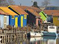
Oyster farms in the Oléron island
-
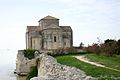
Talmont-sur-Gironde
-
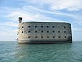
Fort Boyard


Related pages
Images for kids
-
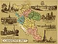
Map of 'Charente-Inférieure' in the 19th century
-
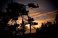
Sunset in Meschers-sur-Gironde in Charente-Maritime
-
Royan, a seaside resort


See also
 In Spanish: Charente Marítimo para niños
