
Oléron facts for kids

The Isle of Oléron (also called Oléron Island) is a beautiful island located off the Atlantic coast of France. It's found west of a city called Rochefort. The island sits on the southern side of the Pertuis d'Antioche strait, which is a narrow passage of water.
Oléron is the second largest island in mainland France, right after Corsica. It stretches about 30 kilometers (18.6 miles) long and is 8 kilometers (5 miles) wide. The island covers an area of 174 square kilometers (67 square miles) and is home to over 21,000 people who live there all year round.
Contents
History of Oléron Island

Oléron Island has been known for a very long time, even since the 1st century! Back then, it was called Uliaros.
Vineyards and Wine
Since the late 200s AD, people on Oléron have been growing grapevines. The Roman emperor Probus allowed all of Gaul (which included France) to have vineyards and make wine. This helped the wine industry grow on the island. Oléron was famous for its wine until the late 1800s. Sadly, a plant disease called phylloxera destroyed almost all the grapevines. This was a very hard time for the island. Today, most of the grapes grown are used to make Cognac.
Early Control of the Island
In the 600s and 700s, Oléron and another island called Ré were known as the Vacetian Islands. This name suggests that the Basque people (also called Vascones) controlled these islands during that time.
Laws of the Sea
Around 1152 to 1160, an important person named Eleanor of Aquitaine introduced the first 'maritime' or 'admiralty' laws in this part of the world. These laws were called the Rolls of Oleron and helped govern shipping and trade at sea. Later, in 1306, Edward I of England gave the island to his son, Edward II, as part of the Duchy of Aquitaine.
The French Revolution and Renaming Villages
During the French Revolution in 1793, many places in France were given new names. The villages on Oléron Island were also renamed to reflect the new ideas of the revolution. For example, Château d'Oléron became "Equality," and Saint-Pierre became "Fraternity." The whole island of Oléron was even called "the island of Liberty."
World War II
During the Second World War, German forces took over Oléron Island and built strong defenses. The island was freed by Free French Forces on April 29, 1945, in a special attack called Operation Jupiter. A French warship, the Duquesne, fired many shells at the German defenses. The German soldiers gave up the next day.
Oyster Production Today
Today, Oléron Island is well-known for its excellent oyster production.
Geography and Climate

Oléron is a fertile island on the Atlantic coast of France, located in the Bay of Biscay.
The weather on the island is usually mild. It gets enough rain, but not too much. In July and August, the summer months, there might be a few days of very hot weather. Oléron is in one of the sunniest areas of the French Atlantic coast, enjoying more than 2100 hours of sunshine each year!
Administration

Oléron Island is part of the Charente-Maritime department in France, which is in the Nouvelle-Aquitaine region. The island is divided into 8 smaller areas called communes:
- La Brée-les-Bains
- Le Château-d'Oléron
- Dolus-d'Oléron
- Le Grand-Village-Plage
- Saint-Denis-d'Oléron
- Saint-Georges-d'Oléron (which includes a place called Boyardville)
- Saint-Pierre d'Oléron
- Saint-Trojan-les-Bains
About 22,000 people live on the island.
Transportation

Since 1966, Oléron Island has been connected to the mainland by a long road bridge. This bridge is 2,862 meters (9,390 feet) long. When it was built, it was the longest bridge in France! Now, it's the third longest. Since 1991, you don't have to pay a toll to cross the bridge.
To reach the island, you can take a train to nearby stations like Surgères, Saintes, or Rochefort. From there, you can catch a bus to the island.

Once you are on the island, the easiest ways to get around are by car or by bicycle. Over the last ten years, a network of 110 kilometers (68 miles) of bicycle paths has been built. Most of these paths are separate from car traffic, making them safe and fun to use.
Tourism

Oléron is a very popular place for tourists to visit. It's a large island on the Atlantic coast of France, only about 3 kilometers (1.8 miles) from the mainland.
Many companies offer boat trips from towns like Boyardville and Saint-Denis. You can visit the nearby Île d'Aix, the city of La Rochelle, or even sail past the famous Fort Boyard.

The port towns on the island are often full of visitors, especially the village of La Cotiniere. This village is home to about a hundred fishing boats called trawlers. They sell their fresh fish every day, usually at 5:00 AM and 4:00 PM. La Cotiniere was the top fishing port in the Charente-Maritime department and the 8th largest in all of France.
Images for kids
-
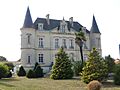
Château Fournier, located in Saint-Georges d'Oléron, shows the island's past as a wine-growing area. Today, it is a retirement home.

See also
 In Spanish: Isla de Oleron para niños
