
Boutonne facts for kids
Quick facts for kids Boutonne |
|
| River | |
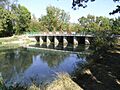
 The Boutonne in Saint-Jean-d'Angély.
|
|
| Country | France |
|---|---|
| Region | Nouvelle-Aquitaine |
| Departments | Deux-Sèvres, Charente-Maritime |
| Communes | Saint-Jean-d'Angély |
| Tributaries | |
| - left | Nie |
| - right | Béronne, Belle, Trézence |
| City | Saint-Jean-d'Angély |
| Source | Chef-Boutonne |
| - location | Deux-Sèvres, Nouvelle-Aquitaine, France |
| - elevation | 90 m (295 ft) |
| - coordinates | 46°06′47″N 0°03′56″W / 46.11306°N 0.06556°W |
| Confluence | Charente |
| - location | Cabariot, Nouvelle-Aquitaine, France |
| - elevation | 4 m (13 ft) |
| - coordinates | 45°54′33″N 0°49′34″W / 45.90917°N 0.82611°W |
| Length | 98.8 km (61 mi) |
| Basin | 1,327 km² (512 sq mi) |
| Discharge | for Cabariot |
| - average | 13 m³/s (459 cu ft/s) |
The Boutonne is a river in western France. It flows through two areas called Deux-Sèvres and Charente-Maritime. These areas are part of the Nouvelle-Aquitaine region. The Boutonne is a smaller river that flows into a larger one, the Charente river.
Contents
About the Boutonne River
The Boutonne river is about 98.8 kilometers (or 61.4 miles) long. It collects water from an area of about 1,327 square kilometers (512 square miles). This area is called its drainage basin.
How Much Water Flows?
On average, about 5.50 cubic meters (194 cubic feet) of water flow through the Boutonne river every second. This measurement was taken near Saint-Séverin-sur-Boutonne. The river is about 34 meters (112 feet) above sea level at this point.
Here's a chart showing how much water flows in the Boutonne river each month:
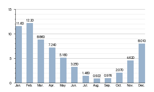
Average monthly water flow (cubic meters per second) at Saint-Séverin-sur-Boutonne (1969-2017)
Where Does the River Start and End?
The Boutonne river begins in the southeast part of the Deux-Sèvres area. It starts in a town called Chef-Boutonne, which means "Head of the Boutonne." Here, the river is about 90 meters (295 feet) above sea level.
The river first flows west, then turns southwest. It goes through the Deux-Sèvres and Charente-Maritime areas. Finally, it flows into the Charente river near Cabariot. At this point, the river is only about 4 meters (13 feet) above sea level.
The Boutonne river flows through one region, two departments, and 41 towns. Some towns even have the river's name in them!
- Deux-Sèvres: Chef-Boutonne (where it starts), Fontenille-Saint-Martin-d'Entraigues, Chérigné, Lusseray, Brioux-sur-Boutonne, Vernoux-sur-Boutonne, Séligné, Brieuil-sur-Chizé, Villefollet, Villiers-sur-Chizé, Chizé, Le Vert.
- Charente-Maritime: Dampierre-sur-Boutonne (the first town in this area), Saint-Séverin-sur-Boutonne, Coivert, Blanzay-sur-Boutonne, Saint-Georges-de-Longuepierre, Saint-Martial, Saint-Pierre-de-l'Isle, Nuaillé-sur-Boutonne, Saint-Pardoult, Les Églises-d'Argenteuil, Antezant-la-Chapelle, Vervant, Poursay-Garnaud, Courcelles, Saint-Julien-de-l'Escap, Saint-Jean-d'Angély (a main city along the river), Ternant, La Vergne, Voissay, Torxé, Les Nouillers, Tonnay-Boutonne, Puy-du-Lac, Archingeay, Saint-Coutant-le-Grand, Champdolent, Lussant, Cabariot (where it joins the Charente river).
Seven towns are named after the river: Chef-Boutonne, Saint-Séverin-sur-Boutonne, Dampierre-sur-Boutonne, Tonnay-Boutonne, Blanzay-sur-Boutonne, Nuaillé-sur-Boutonne, and Vernoux-sur-Boutonne.
What Are the Main Tributaries?
A tributary is a smaller stream or river that flows into a larger one. The Boutonne river has several important tributaries:
|
Rivers flowing into the Boutonne from the left side:
|
Rivers flowing into the Boutonne from the right side:
|
Images for kids
-
A Bridge over the Boutonne in Bel-Ébat.
-
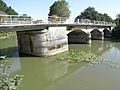
A bridge in Tonnay-Boutonne.
-
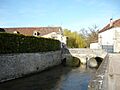
The Boutonne flowing through Dampierre-sur-Boutonne.


Related pages
