
Deux-Sèvres facts for kids
Quick facts for kids
Deux-Sèvres
|
||
|---|---|---|

Niort from the Sèvre Nantaise river
|
||
|
||

Location of Deux-Sèvres in France
|
||
| Region | Nouvelle-Aquitaine | |
| Département | 4 March 1790 | |
| Prefecture | Niort | |
| Subprefectures | Bressuire, Parthenay | |
| Area | ||
| • Total | 5,999.4 km2 (2,316.4 sq mi) | |
| Population
(2014)
|
||
| • Total | 373,553 | |
| • Density | 62.2651/km2 (161.2658/sq mi) | |
| Demonym(s) | Deux-Sévriens | |
| Time zone | UTC+1 (CET) | |
| • Summer (DST) | UTC+2 (CEST) | |
| ISO 3166 code | FR-79 | |
| Arrondissements | 3 | |
| Cantons | 17 | |
| Communes | 297 | |
| Website | http://www.deux-sevres.com | |

Deux-Sèvres is a department located in western France. It is part of the Nouvelle-Aquitaine region.
The name Deux-Sèvres means "Two Sèvres." This refers to two rivers that flow through the department: the Sèvre Nantaise and the Sèvre Niortaise.
Contents
History of Deux-Sèvres
Deux-Sèvres was created on March 4, 1790. It was one of the 83 French departments formed during the French Revolution.
When it was first made, the department had six main areas called districts. These were Melle, Niort, Saint-Maixent, Parthenay, Thouars, and Châtillon (which is now called Mauléon).
The main city, or prefecture, was first shared between Niort, Saint-Maixent, and Parthenay. However, Niort soon became the only main city.
Changes to Administrative Areas
In 1800, France created new administrative areas called arrondissements. The six districts in Deux-Sèvres were changed into four arrondissements: Melle, Niort, Parthenay, and Thouars. In 1804, Thouars was replaced by Bressuire.
Later, in 1926, the arrondissements of Bressuire and Melle were removed. But Bressuire became an arrondissement again in 1942.
A small change to the department's border happened in 1973. The people of a small town called Puy-Saint-Bonnet decided to join the town of Cholet. Cholet is in the nearby department of Maine-et-Loire.
Geography and Nature
Deux-Sèvres is part of the Nouvelle-Aquitaine region. It covers an area of about 5,999.4 square kilometers (2,316.4 square miles).
The highest point in the department is Terrier de Saint-Martin. It is 272 meters (892 feet) high and is located in the town of Saint-Martin-du-Fouilloux.
Neighboring Departments
Deux-Sèvres shares its borders with several other departments:
- To the north: Maine-et-Loire
- To the east: Vienne
- To the southeast: Charente
- To the south: Charente-Maritime
- To the west: Vendée
Rivers of Deux-Sèvres
The main rivers flowing through the department are:
- The Sèvre Niortaise: This river flows through the southern part of Deux-Sèvres and empties into the Atlantic Ocean.
- The Sèvre Nantaise: This river flows through the northern part of the department. It is a smaller river that joins the Loire river.
- The Thouet: This river also joins the Loire river.
Climate in Deux-Sèvres
The climate in Niort, the main city, is an oceanic climate. This means it has mild summers. It is classified as Cfb (Marine West Coast Climate) in the Köppen climate classification.
The average amount of precipitation (rain) in Niort each year is about 647.7 millimeters (25.5 inches). September usually has the most rain, with about 94 millimeters (3.7 inches). July is the driest month, with only about 25.4 millimeters (1 inch) of rain.
The average temperature in Niort for the whole year is 12.5°C (54.5°F). July is the warmest month, with an average temperature of 20.2°C (68.4°F). January is the coolest month, with an average temperature of 5.5°C (41.9°F).
How Deux-Sèvres is Governed
The department is managed by the Departmental Council of the Deux-Sèvres. This council is located in Niort. Deux-Sèvres is part of the larger Nouvelle-Aquitaine region.
Administrative Divisions of Deux-Sèvres
Deux-Sèvres is divided into smaller administrative areas to help manage it.
- There are 3 arrondissements (which are like large districts).
- There are 17 cantons (smaller administrative areas).
- There are 293 communes (which are like municipalities or towns/villages).
Here are the three arrondissements in Deux-Sèvres:
| INSEE code |
Arrondissement | Capital | Population (2014) |
Area (km²) |
Density (Inh./km²) |
Communes |
|---|---|---|---|---|---|---|
| 791 | Bressuire | Bressuire | 96,703 | 1,622.6 | 59.6 | 53 |
| 792 | Niort | Niort | 212,425 | 2,791.6 | 76.1 | 163 |
| 793 | Parthenay | Parthenay | 64,425 | 1,585.1 | 40.6 | 77 |
Population and People
The people who live in Deux-Sèvres are called Deux-Sévriens (for men) or Deux-Sévriennes (for women) in French.
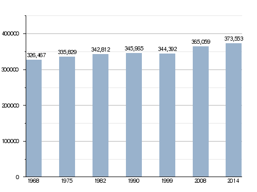
In 2014, Deux-Sèvres had a population of 373,553 people. This means there were about 62.3 inhabitants per square kilometer. The arrondissement of Niort is the largest, with 212,425 people. Bressuire has 96,703 people, and Parthenay has 64,425 people.
How the Population of Deux-Sèvres Has Changed
Main Cities in Deux-Sèvres
Here are the 10 largest cities in the department based on their population in 2014:
| City | Population (2014) |
Arrondissement |
|---|---|---|
| Niort | 58,311 | Niort |
| Bressuire | 19,300 | Bressuire |
| Parthenay | 10,367 | Parthenay |
| Thouars | 9,241 | Bressuire |
| Mauléon | 8,463 | Bressuire |
| Chauray | 6,828 | Niort |
| Saint-Maixent-l’École | 6,537 | Niort |
| Nueil-les-Aubiers | 5,628 | Bressuire |
| Aiffres | 5,486 | Niort |
| La Crèche | 5,471 | Niort |
Economy and Farming
Deux-Sèvres is mostly a rural area, meaning a lot of its land is used for farming. Farmers here mainly grow wheat and oats. They also grow potatoes, apples, and walnuts. In the northern part of the department, there are many vineyards where grapes are grown for wine.
Gallery
-
Coulon


.JPG)

Related pages
Images for kids
See also
 In Spanish: Deux-Sèvres para niños
