
Vienne facts for kids
Quick facts for kids
Vienne
|
||
|---|---|---|

Prefecture building of the Vienne department, in Poitiers
|
||
|
||

Location of Vienne in France
|
||
| Country | France | |
| Region | Nouvelle-Aquitaine | |
| Département | 4 March 1790 | |
| Prefecture | Poitiers | |
| Subprefectures | Châtellerault, Montmorillon | |
| Area | ||
| • Total | 6,990.4 km2 (2,699.0 sq mi) | |
| Population
(2014)
|
||
| • Total | 433,203 | |
| • Density | 61.9711/km2 (160.5045/sq mi) | |
| Demonym(s) | Viennois | |
| Time zone | UTC+1 (CET) | |
| • Summer (DST) | UTC+2 (CEST) | |
| ISO 3166 code | FR-86 | |
| Arrondissements | 3 | |
| Cantons | 19 | |
| Communes | 274 | |
| Website | http://www.lavienne86.fr | |

Vienne is a special area in southwestern France. It's called a department, and it's part of the Nouvelle-Aquitaine region. The department gets its name from the Vienne River, which is the most important river flowing through it.
Contents
History of Vienne
Vienne was created during the French Revolution on March 4, 1790. It was one of the first 83 "departments" that France was divided into. Before this, the area was made up of older provinces like Poitou, Touraine, and Berry. For a long time, until the 1400s, this area was part of the Duchy of Aquitaine.
When Vienne was first formed, it had six main areas called "districts." These were Châtellerault, Civray, Loudun, Lusignan, Montmorillon, and Poitiers. The main city, or capital, was Poitiers. Today, Poitiers is still the main city and is called the prefecture.
Later, in 1800, these districts were changed into five "arrondissements." These new areas were Châtellerault, Civray, Loudun, Montmorillon, and Poitiers. However, in 1926, the Civray and Loudun arrondissements were removed.
Geography of Vienne
Vienne is located in the Nouvelle-Aquitaine region of France. It covers a total area of about 6,990.4 km2 (2,699 sq mi).
The highest point in the department is a place called Signal de Prun. It is 231 m (758 ft) high and is located in the town of Adriers. This area is part of the Massif Central mountain range.
Vienne shares its borders with six other departments from three different regions:
- From the Pays de la Loire region:
- From the Centre-Val de Loire region:
- From the Nouvelle-Aquitaine region:
 |
Maine-et-Loire | Indre-et-Loire | Indre-et-Loire | |
| Deux-Sèvres | Indre | |||
| Deux-Sèvres | Charente | Haute-Vienne |
The most important river in Vienne is the Vienne River. It flows through the department from north to south. The Vienne River is one of the main rivers that flows into the larger Loire River.
Climate in Vienne
The climate in Poitiers, the main city of Vienne, is an oceanic climate. This means it has mild summers. In the Köppen climate classification system, it's known as Cfb, which stands for Marine West Coast Climate.
On average, Poitiers gets about 685.8 mm (27.0 in) of rain each year. The rainiest month is usually October, with about 76.2 mm (3.0 in) of rain. The driest month is August, with only about 40.6 mm (1.6 in) of rain.
The average temperature in Poitiers for the whole year is 11.7 °C (53.1 °F). July is the warmest month, with an average temperature of 19.6 °C (67.3 °F). January is the coolest month, with an average temperature of 4.7 °C (40.5 °F).
Administration of Vienne
The department of Vienne is managed by a group called the Departmental Council of the Vienne. This council is located in Poitiers. Vienne is part of the larger Nouvelle-Aquitaine region.
Administrative Divisions
Vienne is divided into smaller areas to help with its administration. There are:
- 3 arrondissements (which are like large districts)
- 19 cantons (smaller administrative areas)
- 274 communes (which are like towns or municipalities)
Here is a table showing the main arrondissements in Vienne:
| INSEE code |
Arrondissement | Capital | Population (2014) |
Area (km²) |
Density (Inh./km²) |
Communes |
|---|---|---|---|---|---|---|
| 861 | Châtellerault | Châtellerault | 112,313 | 2,065.0 | 54.4 | 92 |
| 862 | Montmorillon | Montmorillon | 74,852 | 2,998.8 | 25.0 | 95 |
| 863 | Poitiers | Poitiers | 246,038 | 1,925.7 | 127.8 | 87 |
The 19 cantons of the Vienne department were reorganized in March 2015. Here is a list of them:
- Chasseneuil-du-Poitou (8601)
- Châtellerault-1 (8602)
- Châtellerault-2 (8603)
- Châtellerault-3 (8604)
- Chauvigny (8605)
- Civray (8606)
- Jaunay-Clan (8607)
- Loudun (8608)
- Lusignan (8609)
- Lussac-les-Châteaux (8610)
- Migné-Auxances (8611)
- Montmorillon (8612)
- Poitiers-1 (8613)
- Poitiers-2 (8614)
- Poitiers-3 (8615)
- Poitiers-4 (8616)
- Poitiers-5 (8617)
- Vivonne (8618)
- Vouneuil-sur-Vienne (8619)
Population and Demographics
The people who live in Vienne are called Viennois in French. If you're talking about a woman, you'd say Viennoise.
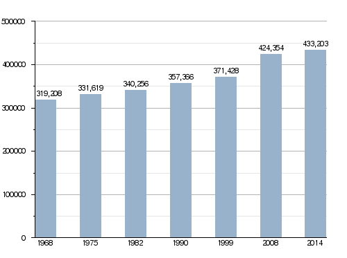
In 2014, Vienne had a population of 433,203 people. This means there were about 62.0 inhabitants per square kilometer. The arrondissement of Poitiers is the largest, with 246,038 people. The other two, Châtellerault and Montmorillon, have 112,313 and 74,852 people, respectively.
How the Population of Vienne Has Changed Over Time
Here are the 10 largest cities in the Vienne department by population:
| City | Population (2014) |
Arrondissement |
|---|---|---|
| Poitiers | 87,435 | Poitiers |
| Châtellerault | 31,722 | Châtellerault |
| Buxerolles | 9,956 | Poitiers |
| Chauvigny | 7,088 | Montmorillon |
| Saint-Benoît | 7,064 | Poitiers |
| Loudun | 6,740 | Châtellerault |
| Montmorillon | 6,155 | Montmorillon |
| Jaunay-Clan | 6,025 | Poitiers |
| Migné-Auxances | 5,966 | Poitiers |
| Naintré | 5,866 | Châtellerault |
Gallery
-
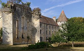
The remains of the old abbey in Saint-Martin-l'Ars.
-
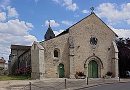
The Saint-Laurent church in Romagne.
-
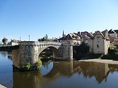
The old bridge of Montmorillon.


Related Pages
Images for kids
-
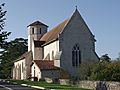
A church in Blanzay.
-
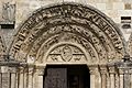
The tympanum (decorated archway) of the church in Civray.


See also
 In Spanish: Vienne para niños
