
Indre (department) facts for kids
Quick facts for kids
Indre
|
|||
|---|---|---|---|

Prefecture building of the Indre department, in Châteauroux
|
|||
|
|||

Location of Indre in France
|
|||
| Country | France | ||
| Region | Centre-Val de Loire | ||
| Département | 4 March 1790 | ||
| Prefecture | Châteauroux | ||
| Subprefectures | Le Blanc, La Châtre, Issoudun | ||
| Area | |||
| • Total | 6,790.6 km2 (2,621.9 sq mi) | ||
| Population
(2014)
|
|||
| • Total | 226,175 | ||
| • Density | 33.3071/km2 (86.2649/sq mi) | ||
| Demonym(s) | Indriens | ||
| Time zone | UTC+1 (CET) | ||
| • Summer (DST) | UTC+2 (CEST) | ||
| ISO 3166 code | FR-36 | ||
| Arrondissements | 4 | ||
| Cantons | 13 | ||
| Communes | 243 | ||
| Website | Official website: http://www.indre.fr/ | ||


Indre is a special area in the middle of France. It is called a department. You can find it in the Centre-Val de Loire region. It gets its name from the Indre river, which is the most important river there.
The main city of Indre is Châteauroux. This city is also known as the prefecture.
Contents
History of Indre
The Indre department was created a long time ago, on March 4, 1790. This happened during the French Revolution. It was made from a part of an older area called Berry.
When it was first made, Indre had six smaller areas called districts. These were Issoudun, Châteauroux, Argenton, Le Blanc, La Châtre, and Marennes. Châteauroux was chosen as the main city.
Later, in 1800, these districts changed into four arrondissements (which are like smaller administrative areas). These were Châteauroux, Le Blanc, La Châtre, and Issoudun.
For a short time, in 1926, the Issoudun arrondissement was removed. But it was brought back in 1942.
Geography of Indre
Indre is part of the Centre-Val de Loire region in France. It covers an area of about 6,790.6 square kilometers (2,621.9 square miles).
The highest point in the department is called Terrior Randoin. It is 457 meters (1,499 feet) above sea level. You can find it in the town of Pouligny-Notre-Dame.
Indre shares its borders with six other departments. These departments are in two different regions:
- In the Centre-Val de Loire region:
* Loir-et-Cher * Cher * Indre-et-Loire
- In the Nouvelle-Aquitaine region:
* Creuse * Vienne * Haute-Vienne
Rivers of Indre
Several important rivers flow through Indre:
- The Creuse River is 264 kilometers (164 miles) long. It eventually joins the Vienne River.
- The Claise River is 88 kilometers (55 miles) long. It is a tributary of the Creuse, meaning it flows into the Creuse.
- The Indre River flows right through the middle of the department. It passes through important towns like La Châtre, Châteauroux, and Loches. The Indre River is a tributary of the Loire River. It joins the Loire near Chinon in the next department over.
Climate in Indre
The climate in Châteauroux, the main city, is known as an "Oceanic climate". This means it has mild temperatures and rain throughout the year.
On average, Châteauroux gets about 736.6 millimeters (29.0 inches) of rain each year. May is usually the wettest month, with about 73.7 millimeters (2.9 inches) of rain. February is the driest month, with about 48.3 millimeters (1.9 inches) of rain.
The average temperature for the whole year in Châteauroux is 11.8°C (53.2°F). July is the warmest month, with an average temperature of 20.2°C (68.4°F). January is the coolest month, with an average temperature of 4.2°C (39.6°F).
How Indre is Managed
The department is run by the Departmental Council of the Indre. This council is located in Châteauroux. Indre is part of the larger Centre-Val de Loire region.
Administrative Divisions
Indre is divided into smaller parts to help manage it. There are:
- 4 arrondissements (these are like large districts)
- 13 cantons (these are smaller areas for elections)
- 243 communes (these are like towns or municipalities)
| INSEE code |
Arrondissement | Capital | Population (2014) |
Area (km²) |
Density (Inh./km²) |
Communes |
|---|---|---|---|---|---|---|
| 361 | Le Blanc | Le Blanc | 31,821 | 1,760.8 | 18.1 | 57 |
| 362 | Châteauroux | Châteauroux | 126,428 | 2,524.3 | 50.1 | 86 |
| 363 | La Châtre | La Châtre | 32,962 | 1,323.2 | 24.9 | 51 |
| 364 | Issoudun | Issoudun | 34,964 | 1,182.3 | 29.6 | 49 |
Here is a list of the 13 cantons in the Indre department. These were updated in March 2015:
- Ardentes (3601)
- Argenton-sur-Creuse (3602)
- Le Blanc (3603)
- Buzançais (3604)
- Châteauroux-1 (3605)
- Châteauroux-2 (3606)
- Châteauroux-3 (3607)
- La Châtre (3608)
- Issoudun (3609)
- Levroux (3610)
- Neuvy-Saint-Sépulchre (3611)
- Saint-Gaultier (3612)
- Valençay (3613)
People of Indre (Demographics)
The people who live in Indre are called Indriens in French.
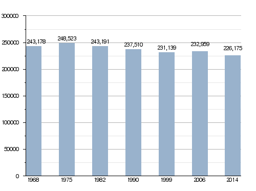
In 2014, Indre had a population of 226,175 people. This means there were about 33.3 people living in each square kilometer. The arrondissement of Châteauroux is the largest, with 126,428 people.
How the population of Indre has changed over time
Main Cities in Indre
Here are some of the biggest cities and towns in the department:
| City | Population (2014) |
Arrondissement |
|---|---|---|
| Châteauroux | 44,479 | Châteauroux |
| Issoudun | 12,270 | Issoudun |
| Déols | 7,744 | Châteauroux |
| Le Blanc | 6,602 | Le Blanc |
| Le Poinçonnet | 5,880 | Châteauroux |
| Argenton-sur-Creuse | 5,007 | Châteauroux |
| Buzançais | 4,473 | Châteauroux |
| La Châtre | 4,278 | La Châtre |
| Ardentes | 3,886 | Châteauroux |
| Saint-Maur | 3,522 | Châteauroux |
Gallery
-
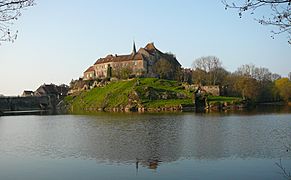
Saint-Benoît-du-Sault
-
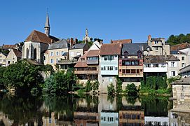
Argenton-sur-Creuse


Related pages
