
Indre River facts for kids
The Indre is a river in central France. It flows into the Loire River from the left side. Two areas in France, called Indre and Indre-et-Loire, are named after this river.
Quick facts for kids Indre |
|
| River | |
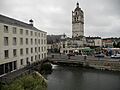
 The Indre in Rigny-Ussé
|
|
| Country | France |
|---|---|
| Region | Centre-Val de Loire |
| Departments | Cher, Indre, Indre-et-Loire |
| Communes | Sainte-Sévère-sur-Indre, La Châtre, Ardentes, Châteauroux, Buzançais, Châtillon-sur-Indre, Loches, Montbazon, Azay-le-Rideau |
| Tributaries | |
| - left | Vauvre |
| - right | Igneraie, Indrois |
| Cities | La Châtre, Châteauroux, Loches |
| Source | Monts de Saint-Marien |
| - location | Saint-Priest-la-Marche, Massif Central, France |
| - elevation | 405 m (1,329 ft) |
| - coordinates | 46°25′59″N 2°10′48″E / 46.43306°N 2.18000°E |
| Confluence | Loire |
| - location | Avoine, Indre-et-Loire, France |
| - elevation | 30 m (98 ft) |
| - coordinates | 47°14′2″N 0°11′0″E / 47.23389°N 0.18333°E |
| Length | 279.3 km (174 mi) |
| Basin | 3,428 km² (1,324 sq mi) |
| Discharge | for Lignières-de-Touraine |
| - average | 18.70 m³/s (660 cu ft/s) |
Contents
River Facts and Figures
The Indre river is about 279.3 km (173.5 mi) long. This is like driving from New York City to Philadelphia and back!
Understanding the River's Flow
The river's drainage basin covers an area of 3,428 km2 (1,324 sq mi). A drainage basin is all the land where water flows into that river. Most of this land is used for farming.
The river's average flow, called its discharge, is about 18.7 m3/s (660 cu ft/s) near Lignières-de-Touraine. This means that much water passes by each second!
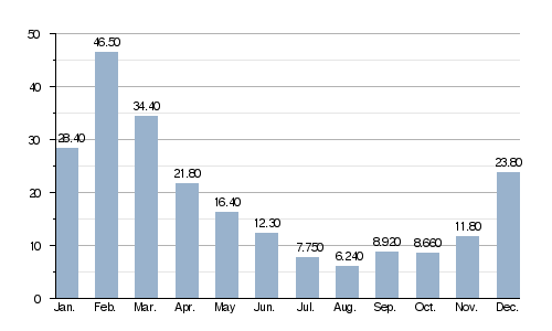
Average monthly discharge (m3/s) at Lignières-de-Touraine
The River's Journey
The Indre river begins in the Monts de Saint-Marien. This area is part of the southwestern Massif Central mountains. The river starts in the small town, or commune, of Saint-Priest-la-Marche. This is in the southern part of the Cher department. The starting point is about 405 m (1,329 ft) high, like a tall building!
Where the Indre Flows
The Indre river flows towards the northwest. It travels through two French departments: Indre and Indre-et-Loire. Both are in the Centre-Val de Loire region. The river passes through 58 different towns and villages. Most of these are in the Indre department.
Here are some of the main towns along its path:
- In the Centre-Val de Loire region:
- Cher: Saint-Priest-la-Marche
- Indre: Sainte-Sévère-sur-Indre, La Châtre, Ardentes, Châteauroux, Villedieu-sur-Indre, Buzançais, Saint-Genou, Châtillon-sur-Indre
- Indre-et-Loire: Loches, Montbazon, Azay-le-Rideau
The Indre river eventually joins the larger Loire River. This happens in the town of Avoine.
Smaller Rivers Joining the Indre
Many smaller rivers flow into the Indre. These are called tributaries. They add more water to the main river.
|
Rivers Joining from the Left:
|
Rivers Joining from the Right:
|
Images for kids
-
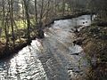
The Indre in Pouligny-Saint-Martin.
-
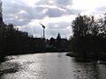
The Indre river in Châteauroux.
-
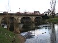
The bridge linking Châteauroux to Déols.
-
The Indre in Loches.
_-_Vue_vers_Sainte-S%C3%A9v%C3%A8re-sur-Indre.jpg)


Related Pages
See also
 In Spanish: Río Indre para niños
