
Cher (department) facts for kids
Quick facts for kids
Cher
|
|||
|---|---|---|---|

Prefecture building of the Cher department, in Bourges
|
|||
|
|||

Location of Cher in France
|
|||
| Country | France | ||
| Region | Centre-Val de Loire | ||
| Département | 4 March 1790 | ||
| Prefecture | Bourges | ||
| Subprefectures | Saint-Amand-Montrond, Vierzon | ||
| Area | |||
| • Total | 7,235.0 km2 (2,793.4 sq mi) | ||
| Population
(2014)
|
|||
| • Total | 310,270 | ||
| • Density | 42.8846/km2 (111.0706/sq mi) | ||
| Demonym(s) | Berrichons | ||
| Time zone | UTC+1 (CET) | ||
| • Summer (DST) | UTC+2 (CEST) | ||
| ISO 3166 code | FR-18 | ||
| Arrondissements | 3 | ||
| Cantons | 19 | ||
| Communes | 290 | ||
| Website | Official website: http://www.departement18.fr/ | ||


Cher is a special area in the middle of France. It is called a department. It is part of the Centre-Val de Loire region. The department gets its name from the Cher river, which is a very important river there.
The main city and administrative center of Cher is Bourges. This city is called the prefecture.
Contents
History of Cher
How the Department was Created
The Cher department was made during the French Revolution on March 4, 1790. It was one of the first 83 departments created in France. Before that, this area was part of an older province called Berry.
When it was first made, the department had seven smaller areas called districts. These were Aubigny, Sancerre, Sancoins, Saint-Amand, Châteaumeillant, Bourges, and Vierzon. Bourges was chosen as the main city.
Changes Over Time
In 1800, the seven districts were changed into three larger areas called arrondissements. These new areas were Bourges, Saint-Amand-Mont-Rond, and Sancerre.
Later, in 1926, the Sancerre arrondissement was removed. But in 1984, a new arrondissement was added: Vierzon. So now, Cher has three arrondissements again.
Geography of Cher
Where is Cher Located?
Cher is located in the Centre-Val de Loire region of France. It covers an area of about 7,235 square kilometers (2,793 square miles).
The highest point in the department is a place called Le Magnoux. It is in the southern part of Cher, in the town of Préveranges. This spot is about 501 meters (1,644 feet) above sea level.
Neighboring Departments
Cher shares its borders with six other departments. These departments are in four different regions of France:
- In the Centre-Val de Loire region:
- Loir-et-Cher (to the northwest)
- Indre (to the west)
- Loiret (to the north)
- In the Nouvelle-Aquitaine region:
- Creuse (to the south)
- In the Auvergne-Rhône-Alpes region:
- Allier (to the southeast)
- In the Bourgogne-Franche-Comté region:
- Nièvre (to the east)
 |
Loir-et-Cher | Loiret | Nièvre | |
| Indre | Nièvre | |||
| Indre | Creuse | Allier |
Main Rivers
Several important rivers flow through the Cher department:
- The Cher River: This river is about 368 kilometers (229 miles) long. It flows into the Loire. The department is named after this river.
- The Allier River: This river is about 421 kilometers (261 miles) long. It also flows into the Loire.
- The Indre River: This river is about 279 kilometers (173 miles) long and joins the Loire.
- The Sauldre River: This river is about 183 kilometers (114 miles) long and flows into the Cher River.
Climate in Cher
The climate in Bourges, the main city, is an "Oceanic climate". This means it has mild temperatures and rain throughout the year. It's also known as a Marine West Coast Climate.
On average, Bourges gets about 665.5 millimeters (26.2 inches) of rain each year. November is usually the wettest month, and February is the driest.
The average temperature in Bourges for the whole year is about 11.7°C (53.1°F). July is the warmest month, with an average of 20.2°C (68.4°F). January is the coolest, with an average of 4°C (39.2°F).
Administration of Cher
How Cher is Governed
The Cher department is run by the Departmental Council of the Cher. This council meets in Bourges. Cher is part of the larger Centre-Val de Loire region.
Administrative Divisions
The Cher department is divided into smaller parts to help with its administration:
- 3 arrondissements (these are like large districts)
- 19 cantons (these are smaller areas, often grouping several towns)
- 290 communes (these are the smallest local government areas, like towns or villages)
Here's a look at the arrondissements in Cher:
| INSEE code |
Arrondissement | Capital | Population (2014) |
Area (km²) |
Density (Inh./km²) |
Communes |
|---|---|---|---|---|---|---|
| 181 | Bourges | Bourges | 173,889 | 2,797.8 | 62.2 | 131 |
| 182 | Saint-Amand-Montrond | Saint-Amand-Montrond | 65,145 | 2,669.8 | 24.4 | 116 |
| 183 | Vierzon | Vierzon | 71,236 | 1,767.4 | 40.3 | 43 |
Here are the 19 cantons of the Cher department. These were reorganized in March 2015:
- Aubigny-sur-Nère (1801)
- Avord (1802)
- Bourges-1 (1803)
- Bourges-2 (1804)
- Bourges-3 (1805)
- Bourges-4 (1806)
- Chârost (1807)
- Châteaumeillant (1808)
- Dun-sur-Auron (1809)
- La Guerche-sur-l'Aubois (1810)
- Mehun-sur-Yèvre (1811)
- Saint-Amand-Montrond (1812)
- Saint-Doulchard (1813)
- Saint-Germain-du-Puy (1814)
- Saint-Martin-d'Auxigny (1815)
- Sancerre (1816)
- Trouy (1817)
- Vierzon-1 (1818)
- Vierzon-2 (1819)
People of Cher
Population and Demographics
The people who live in Cher are called Chériens (for men) or Chériennes (for women) in French. They are also often called Berrichons (men) or Berrichonnes (women).
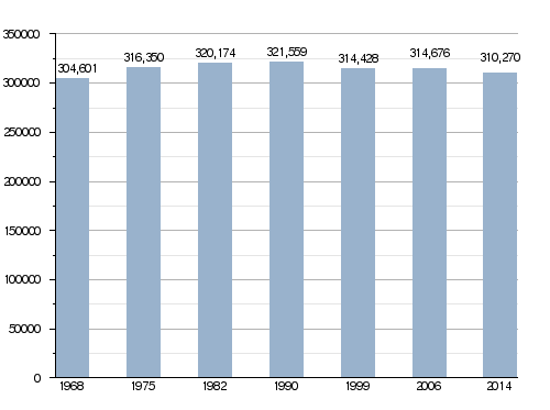
In 2014, the Cher department had a population of 310,270 people. This means there were about 42.9 people living in each square kilometer. The arrondissement of Bourges is the largest, with 173,889 people.
Here's how the population of Cher has changed over the years:
Evolution of the population in Cher
Main Cities in Cher
Here are some of the biggest cities in the Cher department:
| City | Population (2014) |
Arrondissement |
|---|---|---|
| Bourges | 66,528 | Bourges |
| Vierzon | 27,050 | Vierzon |
| Saint-Amand-Montrond | 10,161 | Saint-Amand-Montrond |
| Saint-Doulchard | 9,363 | Bourges |
| Mehun-sur-Yèvre | 6,717 | Vierzon |
| Saint-Florent-sur-Cher | 6,616 | Bourges |
| Aubigny-sur-Nère | 5,560 | Vierzon |
| Saint-Germain-du-Puy | 5,063 | Bourges |
| Dun-sur-Auron | 3,948 | Saint-Amand-Montrond |
| Trouy | 3,917 | Bourges |
Gallery
-
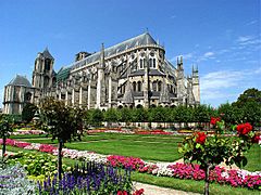
The Saint-Etienne cathedral in Bourges.
-
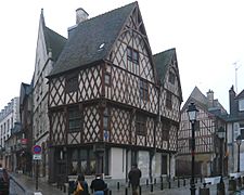
Houses in Bourges.
-
Apremont-sur-Allier.
-
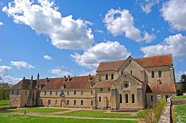
Noirlac Abbey.
-
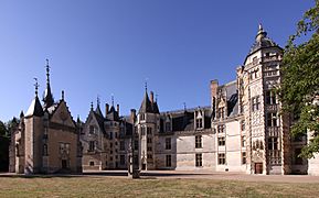
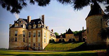
Château de Meillant.


Related pages
See also
 In Spanish: Cher (departamento) para niños
