
Loir-et-Cher facts for kids
Quick facts for kids
Loir-et-Cher
|
|||
|---|---|---|---|

Prefecture building of the Loir-et-Cher department, in Blois
|
|||
|
|||

Location of Loir-et-Cher in France
|
|||
| Country | France | ||
| Region | Centre-Val de Loire | ||
| Département | 4 March 1790 | ||
| Prefecture | Blois | ||
| Subprefectures | Vendôme, Romorantin-Lanthenay | ||
| Area | |||
| • Total | 6,343.4 km2 (2,449.2 sq mi) | ||
| Population
(2014)
|
|||
| • Total | 333,567 | ||
| • Density | 52.5849/km2 (136.1942/sq mi) | ||
| Demonym(s) | Loir-et-Chériens | ||
| Time zone | UTC+1 (CET) | ||
| • Summer (DST) | UTC+2 (CEST) | ||
| ISO 3166 code | FR-41 | ||
| Arrondissements | 3 | ||
| Cantons | 15 | ||
| Communes | 276 | ||
| Website | Official website: http://www.le-loir-et-cher.fr/ | ||


Loir-et-Cher is a department in the middle of France. It is part of the Centre-Val de Loire region. The department gets its name from two rivers, the Loir and the Cher, which flow through it.
The main city and administrative center is Blois. There are also two smaller administrative centers called subprefectures: Romorantin-Lanthenay and Vendôme.
Contents
History of Loir-et-Cher
How the Department Was Formed
Loir-et-Cher is one of the 83 departments created during the French Revolution on March 4, 1790. It was formed mostly from a part of an older province called Orléanais. Some small pieces of other provinces were also added.
When it was first made, the department had six smaller areas called districts. These were Blois, Vendôme, Romorantin, Mondoubleau, Mer, and Saint-Aignan. The main city, or prefecture, was Blois.
Changes Over Time
In 1800, France created new administrative areas called arrondissements. The six districts in Loir-et-Cher became three arrondissements: Blois, Romorantin, and Vendôme.
After the famous Battle of Waterloo in 1815, the Prussian army took over the department. They stayed there from June 1815 until November 1818.
Later, in 1926, the Romorantin arrondissement was removed. But it was brought back in 1943. In 1961, Romorantin joined with a nearby town called Lanthenay. This created the new name for the town and arrondissement: Romorantin-Lanthenay.
Geography of Loir-et-Cher
Location and Size
Loir-et-Cher is located in the Centre-Val de Loire region of France. It covers an area of about 6,343.4 square kilometers (2,449.2 square miles).
The highest point in the department is in a place called Bois des Vallèes. This spot is in the town of Bouffry and is 256 meters (840 feet) above sea level.
Neighboring Departments
Loir-et-Cher shares its borders with six other departments. These departments are in two different regions:
- Centre-Val de Loire region:
- Pays de la Loire region:
 |
Sarthe | Eure-et-Loir | |
|
| Indre-et-Loire | Loiret | |||
| Indre | Cher |
Main Rivers
Several important rivers flow through Loir-et-Cher:
- The Loire river runs through the middle of the department. The city of Blois is located along this river.
- The Loir river flows through the northern part. It is a tributary (a smaller river that flows into a larger one) of the Sarthe river.
- The Cher river flows through the southern part. It is also a tributary, joining the Loire river.
- The Sauldre river is a tributary of the Cher river.
Climate of Loir-et-Cher
The climate in Loir-et-Cher, especially around Vendôme, is known as an "Oceanic climate". This type of climate is also called a Marine West Coast Climate. It has the subtype Cfb.
On average, Vendôme gets about 604.5 millimeters (23.8 inches) of precipitation each year. October usually has the most rain, with about 58.4 mm (2.3 inches). February is typically the driest month, with about 40.6 mm (1.6 inches) of rain.
The average yearly temperature in Vendôme is 10°C (50°F). July is the warmest month, with an average temperature of 18.9°C (66.0°F). January is the coolest, with an average temperature of 1.7°C (35.1°F).
Administration of Loir-et-Cher
How the Department is Governed
The department of Loir-et-Cher is run by the Departmental Council of the Loir-et-Cher. This council meets in the city of Blois. Loir-et-Cher is part of the larger Centre-Val de Loire region.
Administrative Divisions
Loir-et-Cher is divided into several administrative areas:
- 3 arrondissements (districts)
- 15 cantons
- 276 communes (municipalities or towns)
Here is a table showing the arrondissements and their main details:
| INSEE code |
Arrondissement | Capital | Population (2014) |
Area (km²) |
Density (Inh./km²) |
Communes |
|---|---|---|---|---|---|---|
| 411 | Blois | Blois | 173,125 | 2,238.9 | 77.3 | 94 |
| 412 | Vendôme | Vendôme | 70,205 | 1,719.4 | 40.8 | 105 |
| 413 | Romorantin-Lanthenay | Romorantin-Lanthenay | 90,237 | 2,385.2 | 37.8 | 77 |
The following is a list of the 15 cantons in Loir-et-Cher. This list follows the changes made in March 2015:
- La Beauce (4101)
- Blois-1 (4102)
- Blois-2 (4103)
- Blois-3 (4104)
- Chambord (4105)
- Montoire-sur-le-Loir (4106)
- Montrichard (4107)
- Onzain (4108)
- Le Perche (4109)
- Romorantin-Lanthenay (4110)
- Saint-Aignan (4111)
- Selles-sur-Cher (4112)
- La Sologne (4113)
- Vendôme (4114)
- Vineuil (4115)
Demographics of Loir-et-Cher
Population and Density
People who live in Loir-et-Cher are called Loir-et-Chériens in French. If they are women, they are called Loir-et-Chériennes.
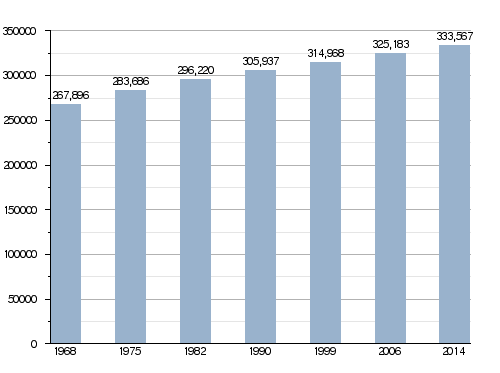
In 2014, the department had a population of 333,567 people. This means there were about 52.6 inhabitants per square kilometer. The arrondissement of Blois is the largest, with 173,125 people.
Population Changes Over Time
Here is a chart showing how the population of Loir-et-Cher has changed over the years:
Evolution of the population in Loir-et-Cher
Main Cities and Towns
Here are some of the biggest cities and towns in the department:
| City | Population (2014) |
Arrondissement |
|---|---|---|
| Blois | 46,351 | Blois |
| Romorantin-Lanthenay | 17,459 | Romorantin-Lanthenay |
| Vendôme | 16,879 | Vendôme |
| Vineuil | 7,638 | Blois |
| Mer | 6,197 | Blois |
| Salbris | 5,398 | Romorantin-Lanthenay |
| Lamotte-Beuvron | 4,767 | Romorantin-Lanthenay |
| Selles-sur-Cher | 4,661 | Romorantin-Lanthenay |
| La Chaussée-Saint-Victor | 4,489 | Blois |
| Saint-Laurent-Nouan | 4,305 | Blois |
Gallery
-
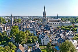
A view of Vendôme.
-
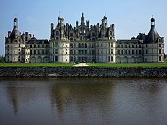
The back of the Château (castle) of Chambord.
-
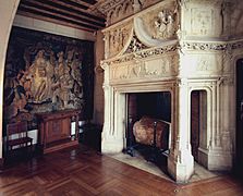
Inside the Château (castle) of Chaumont-sur-Loire.
-
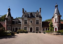
The Château de Troussay, located in Cheverny.

.jpg)
.JPG)


Related pages
See also
 In Spanish: Loir y Cher para niños
