
Eure-et-Loir facts for kids
Quick facts for kids
Eure-et-Loir
|
|||
|---|---|---|---|
,_Chartres_(France).JPG)
Prefecture building of the Eure-et-Loir department, in Chartres.
|
|||
|
|||

Location of Eure-et-Loir in France
|
|||
| Country | France | ||
| Region | Centre-Val de Loire | ||
| Département | 4 March 1790 | ||
| Prefecture | Chartres | ||
| Subprefectures | Châteaudun, Dreux, Nogent-le-Rotrou | ||
| Area | |||
| • Total | 5,880.0 km2 (2,270.3 sq mi) | ||
| Population
(2014)
|
|||
| • Total | 433,762 | ||
| • Density | 73.7690/km2 (191.0610/sq mi) | ||
| Demonym(s) | Euréliens | ||
| Time zone | UTC+1 (CET) | ||
| • Summer (DST) | UTC+2 (CEST) | ||
| ISO 3166 code | FR-28 | ||
| Arrondissements | 4 | ||
| Cantons | 15 | ||
| Communes | 375 | ||
| Website | Official website: http://www.eurelien.fr/ | ||


Eure-et-Loir is a department in north-central France. It is part of the Centre-Val de Loire region. This department gets its name from two important rivers that flow through it: the Eure and the Loir.
Its main city, called the prefecture, is Chartres. There are also three smaller main towns, or subprefectures: Châteaudun, Dreux, and Nogent-le-Rotrou.
Contents
A Look Back in Time

Eure-et-Loir was created during the French Revolution on March 4, 1790. It was one of the first 83 departments made in France. The land for this new department came from older areas called Orléanais, Maine, and Île-de-France.
When it was first made, Eure-et-Loir had six smaller areas called districts. These were Chartres, Châteauneuf-en-Thymerais, Châteaudun, Dreux, Janville, and Nogent-le-Rotrou. Chartres was chosen as the main city, or capital.
In 1800, France changed its administrative system. The six districts became four arrondissements: Chartres, Châteaudun, Dreux, and Nogent-le-Rotrou.
Later, in 1926, the arrondissement of Nogent-le-Rotrou was removed. But in 1943, it became an arrondissement again.
Exploring the Geography
Eure-et-Loir is located in the Centre-Val de Loire region. It covers an area of about 5,880 square kilometers (2,270 square miles).
Neighboring Departments
This department shares its borders with seven other departments from four different regions:
- From the Centre-Val de Loire region:
- From the Île-de-France region:
- From the Pays de la Loire region:
- From the Normandy region:
 |
Eure | Eure | Yvelines | |
| Orne | Essonne | |||
| Sarthe | Loir-et-Cher | Loiret |
Rivers and Highest Point
The highest point in Eure-et-Loir is a hill called the Butte de Rougemont. It is located in the town of Vichères and stands 287 meters (942 feet) above sea level.
The rivers in the department flow into two main river systems:
- To the north, rivers flow into the Seine river system. The Eure river is an important tributary here.
- To the south, rivers flow into the Loire river system. The Loir river is a key tributary in this area.
Climate Overview
The climate in Chartres, the main city, is an "Oceanic climate". This means it has mild temperatures and rainfall throughout the year.
On average, Chartres receives about 916.9 millimeters (36.1 inches) of rain each year. November is usually the wettest month, while July is the driest.
The average temperature in Chartres for the whole year is 11°C (51.8°F). July is the warmest month, with an average of 18.9°C (66.0°F). January is the coolest, with an average of 3.8°C (38.8°F).
How Eure-et-Loir is Managed
The department is run by the Departmental Council of the Eure-et-Loir. This council is based in Chartres. Eure-et-Loir is part of the larger Centre-Val de Loire region.
Administrative Areas
Eure-et-Loir is divided into several administrative areas to help manage it. There are:
- 4 arrondissements (which are like large districts)
- 15 cantons (smaller groups of towns)
- 375 communes (individual municipalities or towns)
Here's a look at the main arrondissements:
| INSEE code |
Arrondissement | Main City | Population (2014) |
Area (km²) |
Density (People/km²) |
Communes |
|---|---|---|---|---|---|---|
| 281 | Chartres | Chartres | 207,869 | 2,129.5 | 97.6 | 151 |
| 282 | Châteaudun | Châteaudun | 59,794 | 1,438.8 | 41.6 | 64 |
| 283 | Dreux | Dreux | 129,431 | 1,500.5 | 86.3 | 108 |
| 284 | Nogent-le-Rotrou | Nogent-le-Rotrou | 36,668 | 811.1 | 45.2 | 52 |
Here are the 15 cantons of Eure-et-Loir. These were updated in March 2015:
- Anet (2801)
- Auneau (2802)
- Brou (2803)
- Chartres-1 (2804)
- Chartres-2 (2805)
- Chartres-3 (2806)
- Châteaudun (2807)
- Dreux-1 (2808)
- Dreux-2 (2809)
- Épernon (2810)
- Illiers-Combray (2811)
- Lucé (2812)
- Nogent-le-Rotrou (2813)
- Saint-Lubin-des-Joncherets (2814)
- Voves (2815)
Population and Cities
The people who live in Eure-et-Loir are called Euréliens in French.
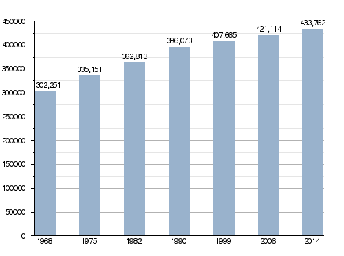
In 2014, Eure-et-Loir had a population of 433,762 people. This means there were about 68.4 inhabitants per square kilometer. The arrondissement of Chartres is the largest, with 207,869 people.
Population Growth Over Time
Evolution of the population in Eure-et-Loir
Major Cities and Towns
Here are the main cities and towns in the department, based on their 2014 population:
| City | Population (2014) |
Arrondissement |
|---|---|---|
| Chartres | 38,728 | Chartres |
| Dreux | 31,191 | Dreux |
| Lucé | 16,240 | Chartres |
| Châteaudun | 13,264 | Châteaudun |
| Vernouillet | 12,415 | Dreux |
| Mainvilliers | 10,558 | Chartres |
| Nogent-le-Rotrou | 10,130 | Nogent-le-Rotrou |
| Luisant | 6,710 | Chartres |
| Lèves | 5,671 | Chartres |
| Auneau-Bleury-Saint-Symphorien | 5,543 | Chartres |
Gallery
-
A view of Nogent-le-Rotrou.
-
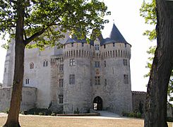
The historic Châteaudun castle.
-
Bonneval Abbey.
-
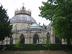
The Chapelle royale in Dreux.


Related pages
See also
 In Spanish: Eure y Loir para niños
