Arrondissement of Nogent-le-Rotrou facts for kids
Quick facts for kids
Arrondissement of Nogent-le-Rotrou
|
|
|---|---|

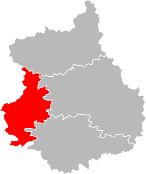
Location of Nogent-le-Rotrou in Eure-et-Loir
|
|
| Country | France |
| Region | Centre-Val de Loire |
| Department | Eure-et-Loir |
| Communes | 52 |
| Subprefecture | Nogent-le-Rotrou |
| INSEE code | 284 |
| Area | |
| • Total | 811.1 km2 (313.2 sq mi) |
| Population
(2014)
|
|
| • Total | 36,668 |
| • Density | 45.208/km2 (117.088/sq mi) |
The arrondissement of Nogent-le-Rotrou is a special kind of area in France. You can think of it like a district or a county. It's located in the Eure-et-Loir department, which is part of the Centre-Val de Loire region. The main town, or capital, of this arrondissement is Nogent-le-Rotrou.
Contents
History of Nogent-le-Rotrou Arrondissement
The Nogent-le-Rotrou arrondissement has an interesting history. It was first created in 1800. This happened when the Eure-et-Loir department was formed.
Later, in 1926, the arrondissement was removed. But it didn't stay gone for long! In 1943, Nogent-le-Rotrou became an arrondissement again. It has been an important part of the department ever since.
Geography of Nogent-le-Rotrou Arrondissement
The Nogent-le-Rotrou arrondissement is in the western part of the Eure-et-Loir department. It is the smallest arrondissement in the department. Its area is about 811 square kilometers (313 square miles).
It also has the fewest people living in it. In 2014, about 36,668 people lived there.
This area shares its borders with several other places. To the north, it borders the Dreux arrondissement. To the east, it borders the Chartres arrondissement. The Châteaudun arrondissement is to its southeast.
It also borders other departments. To the south, it touches the Loir-et-Cher department. The Sarthe department is to its southwest. Finally, the Orne department is to its west.
How Nogent-le-Rotrou Arrondissement is Organized
The arrondissement is made up of smaller parts. These parts include cantons and communes.
Cantons in Nogent-le-Rotrou
Cantons are like electoral divisions. They are not always fully inside one arrondissement. This means a canton might have towns that belong to different arrondissements.
The cantons that are part of the Nogent-le-Rotrou arrondissement are:
- Brou (partly)
- Illiers-Combray (partly)
- Nogent-le-Rotrou
Communes in Nogent-le-Rotrou
Communes are like small towns or villages. The Nogent-le-Rotrou arrondissement has 52 communes.
Here are some of the communes with the most people living in them:
| Commune | Population (2014) |
|---|---|
| Nogent-le-Rotrou | 10,130 |
| La Loupe | 3,527 |
| Authon-du-Perche | 1,240 |
| La Bazoche-Gouet | 1,234 |
| Margon | 1,233 |
| Thiron-Gardais | 1,031 |
| Saint-Éliph | 954 |
| Fontaine-Simon | 951 |
| Belhomert-Guéhouville | 807 |
Related Topics
See also
 In Spanish: Distrito de Nogent-le-Rotrou para niños
 | Chris Smalls |
 | Fred Hampton |
 | Ralph Abernathy |

