
Arrondissements of the Eure-et-Loir department facts for kids
France is divided into different areas to help manage the country better. One type of area is called a department. Inside each department, there are smaller parts known as arrondissements. You can think of an arrondissement like a large district or a borough. The Eure-et-Loir department has 4 arrondissements.
Each arrondissement has a main city, which is like its capital. This special city is called a subprefecture. If the main capital city of the whole department is also in an arrondissement, then that city acts as the capital for both.
Arrondissements are then split into even smaller areas called communes. These are like towns or local communities.
Contents
The Arrondissements of Eure-et-Loir
The Eure-et-Loir department has four main arrondissements. Each one has its own capital city, population, and area. Here's a quick look at them:
| INSEE code |
Arrondissement | Capital | Population (2014) |
Area (km²) |
Density (Inh./km²) |
Communes |
|---|---|---|---|---|---|---|
| 281 | Chartres | Chartres | 207,869 | 2,129.5 | 97.6 | 151 |
| 282 | Châteaudun | Châteaudun | 59,794 | 1,438.8 | 41.6 | 64 |
| 283 | Dreux | Dreux | 129,431 | 1,500.5 | 86.3 | 108 |
| 284 | Nogent-le-Rotrou | Nogent-le-Rotrou | 36,668 | 811.1 | 45.2 | 52 |
A Look at the Past: How Arrondissements Changed
The Eure-et-Loir department has seen a few changes to its arrondissements over time:
- In 1790, the department was first created. It had six main areas called districts. These were Chartres, Châteaudun, Châteauneuf-en-Thymerais, Dreux, Janville, and Nogent-le-Rotrou. The main capital city was Chartres.
- By 1800, these districts were reorganized into four arrondissements: Chartres, Châteaudun, Dreux, and Nogent-le-Rotrou.
- In 1926, the arrondissement of Nogent-le-Rotrou was removed.
- However, in 1943, Nogent-le-Rotrou was made an arrondissement again.
See Also
Images for kids
-
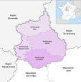
Map of arrondissements of the Eure-et-Loir department.

