
Loiret facts for kids
Quick facts for kids
Loiret
|
|||
|---|---|---|---|
.jpg)
Prefecture building of the Loiret department, in Orléans.
|
|||
|
|||

Location of Loiret in France
|
|||
| Country | France | ||
| Region | Centre-Val de Loire | ||
| Département | 4 March 1790 | ||
| Prefecture | Orléans | ||
| Subprefectures | Montargis, Pithiviers | ||
| Area | |||
| • Total | 6,775.2 km2 (2,615.9 sq mi) | ||
| Population
(2014)
|
|||
| • Total | 669,737 | ||
| • Density | 98.8513/km2 (256.0236/sq mi) | ||
| Demonym(s) | Loiretains | ||
| Time zone | UTC+1 (CET) | ||
| • Summer (DST) | UTC+2 (CEST) | ||
| ISO 3166 code | FR-45 | ||
| Arrondissements | 3 | ||
| Cantons | 21 | ||
| Communes | 326 | ||
| Website | Official website: http://www.loiret.fr/ | ||


Loiret is a department in north-central France. It is part of the Centre-Val de Loire region. The department is named after the Loiret river. This river is a tributary of the Loire and flows entirely within the department.
The main city and administrative center of Loiret is Orléans. There are also two smaller administrative centers called subprefectures: Montargis and Pithiviers.
Contents
History of Loiret
The Loiret department was created on March 4, 1790. This happened during the French Revolution. It was formed from a part of an older area called Orléanais.
When it was first made, the department had seven main areas called districts. These were Orléans, Beaugency, Neuville, Pithiviers, Montargis, Gien, and Boiscommun. Orléans was chosen as the main city, or capital.
In 1800, France changed its administrative system. The seven districts were replaced by four larger areas called arrondissements. These new areas were Orléans, Gien, Montargis, and Pithiviers.
After a big battle called the Battle of Waterloo in 1815, the department was occupied. The Bavarian army stayed there from June 1815 to November 1818.
Later, in 1926, the arrondissements of Gien and Pithiviers were removed. However, Pithiviers became an arrondissement again in 1942.
Geography of Loiret
Loiret is located in the Centre-Val de Loire region. It covers an area of about 6,775 square kilometers (2,616 square miles).
The department shares its borders with seven other departments. These departments are in three different regions of France:
- In the Centre-Val de Loire region:
* Eure-et-Loir * Cher * Loir-et-Cher
- In the Île-de-France region:
- In the Bourgogne-Franche-Comté region:
 |
Eure-et-Loir | Essonne, Seine-et-Marne | Yonne | |
| Eure-et-Loir | Yonne | |||
| Loir-et-Cher | Loir-et-Cher, Cher | Nièvre |
The highest point in Loiret is called Col des Étourneaux. It is located in the town of Pierrefitte-ès-Bois. This spot is about 273 meters (896 feet) above sea level. It is found in the northwestern part of the Massif Central mountain range.
Rivers of Loiret
Several important rivers flow through the Loiret department:
- The Loire: This major river flows through the department from the southeast to the west.
- The Loiret: This is a short river that flows into the Loire. It is the river that gives the department its name.
- The Loing: This river is about 142 kilometers (88 miles) long.
- The Cosson: This river is 96.4 kilometers (59.9 miles) long.
- The Essonne: This river is about 97 kilometers (60 miles) long.
Natural Areas of Loiret
Loiret has several different natural landscapes:
- The Loire Valley: This is the area around the Loire river.
- Beauce: Located in the northwest, this is a flat limestone plateau. It is a very important farming region, especially for growing wheat.
- Gâtinais: This area is to the east, around the city of Montargis.
- The Forêt d'Orléans ("Forest of Orléans"): This is the largest national forest in France. It is north of the Loire river and south of the Beauce region.
- Sologne: This region is located south of the Loire river.
- Berry: A small part of this region extends into the southeast of Loiret.
- Puisaye: This area is found between the Berry and Gâtinais regions.
Climate in Loiret
The climate in Orléans, the main city, is an "Oceanic climate". This type of climate is also known as a Marine West Coast Climate. It means the weather is generally mild.
On average, Orléans gets about 599.4 millimeters (23.6 inches) of precipitation each year. August is usually the wettest month, with about 58.4 millimeters (2.3 inches) of rain. March is typically the driest month, with around 38.1 millimeters (1.5 inches) of rain.
The average temperature in Orléans for the whole year is 10.6°C (51.1°F). July is the warmest month, with an average temperature of 18.3°C (64.9°F). January is the coolest month, with an average temperature of 2.8°C (37.0°F).
Administration of Loiret
The department is managed by a group called the Departmental Council of the Loiret. This council is based in Orléans. Loiret is part of the Centre-Val de Loire region.
Administrative Divisions
Loiret is divided into 3 arrondissements (which are like districts). It also has 21 cantons and 326 communes (which are like towns or municipalities).
| Arrondissement | Capital | Population (2014) |
Area (km²) |
Density (Inh./km²) |
Communes |
|---|---|---|---|---|---|
| Montargis | Montargis | 170,781 | 2,631.3 | 64.9 | 126 |
| Orléans | Orléans | 435,676 | 2,945.8 | 147.9 | 121 |
| Pithiviers | Pithiviers | 63,280 | 1,198.1 | 52.8 | 79 |
Here is a list of the 21 cantons in the Loiret department. These were reorganized in March 2015:
- Beaugency
- Châlette-sur-Loing
- Châteauneuf-sur-Loire
- Courtenay
- La Ferté-Saint-Aubin
- Fleury-les-Aubrais
- Gien
- Lorris
- Malesherbes
- Meung-sur-Loire
- Montargis
- Olivet
- Orléans-1
- Orléans-2
- Orléans-3
- Orléans-4
- Pithiviers
- Saint-Jean-de-Braye
- Saint-Jean-de-la-Ruelle
- Saint-Jean-le-Blanc
- Sully-sur-Loire
Population of Loiret
People who live in Loiret are called Loiretains in French.
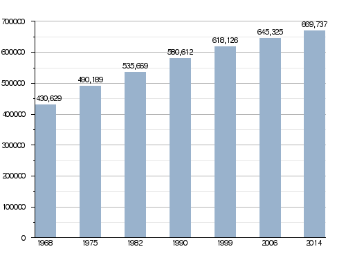
In 2014, Loiret had a population of 669,737 people. This means there were about 98.9 inhabitants per square kilometer (256 inhabitants per square mile). The arrondissement of Orléans is the largest, with 435,676 people.
How the Population of Loiret Has Changed Over Time
Main Cities in Loiret
Here are some of the biggest cities in the department:
| City | Population (2014) |
Arrondissement |
|---|---|---|
| Orléans | 114,977 | Orléans |
| Olivet | 21,192 | Orléans |
| Fleury-les-Aubrais | 20,791 | Orléans |
| Saint-Jean-de-Braye | 19,804 | Orléans |
| Saint-Jean-de-la-Ruelle | 16,415 | Orléans |
| Saran | 15,686 | Orléans |
| Gien | 14,617 | Montargis |
| Montargis | 13,997 | Montargis |
| Amilly | 12,672 | Montargis |
| Châlette-sur-Loing | 12,643 | Montargis |
| La Chapelle-Saint-Mesmin | 10,117 | Orléans |
Images for kids
-
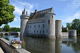
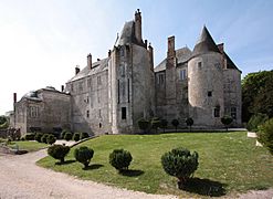
Château de Sully-sur-Loire
-
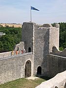
Yèvre-le-Châtel
-
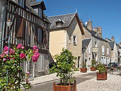
Beaugency
-
Meung-sur-Loire


Related Pages
See also
 In Spanish: Loiret para niños
