Arrondissement of Orléans facts for kids
Quick facts for kids
Arrondissement of Orléans
|
|
|---|---|

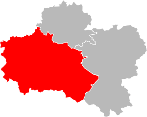
Location of Orléans in Loiret
|
|
| Country | France |
| Region | Centre-Val de Loire |
| Department | Loiret |
| Communes | 121 |
| Prefecture | Orléans |
| INSEE code | 452 |
| Area | |
| • Total | 2,945.8 km2 (1,137.4 sq mi) |
| Population
(2014)
|
|
| • Total | 435,676 |
| • Density | 147.8973/km2 (383.052/sq mi) |
The arrondissement of Orléans is like a special administrative area in France. Think of it as a big district or region within a larger department. Its main city, or "capital," is Orléans. This area is part of the Loiret department, which is located in the Centre-Val de Loire region of France.
Contents
History of Orléans Arrondissement
When the Loiret department was first created in 1800, the Orléans area was already a part of it. It has been an important administrative center ever since.
Geography of Orléans Arrondissement
The Orléans arrondissement is located in the southwest part of the Loiret department. This area is where three different natural regions meet: Beauce, Val de Loire, and Sologne.
It is the largest arrondissement in the Loiret department. It covers about 2,945.8 square kilometers (about 1,137 square miles). It also has the most people living in it, with 435,676 inhabitants as of 2014.
This area shares its borders with several other places. To the north, it borders the Pithiviers arrondissement. To the northeast and east, it borders the Montargis arrondissement. The Cher department is to its southeast. To the south and west, it borders the Loir-et-Cher department. Finally, to the northwest, it borders the Eure-et-Loir department.
How Orléans Arrondissement is Organized
The Orléans arrondissement is made up of smaller parts called cantons and communes. These are like smaller towns and local areas.
Cantons in Orléans Arrondissement
Cantons are groups of communes. They are used for elections and some local services. After a change in how cantons are organized in France, they can now include communes that belong to different arrondissements.
Some of the cantons in the Orléans arrondissement include:
- Beaugency
- Châteauneuf-sur-Loire
- La Ferté-Saint-Aubin
- Fleury-les-Aubrais
- Meung-sur-Loire
- Olivet
- Orléans-1
- Orléans-2
- Orléans-3
- Orléans-4
- Saint-Jean-de-Braye
- Saint-Jean-de-la-Ruelle
- Saint-Jean-le-Blanc
- Sully-sur-Loire
Communes in Orléans Arrondissement
Communes are like towns or villages, each with its own local government. The Orléans arrondissement has 121 communes. These are the smallest administrative divisions in France.
Here are some of the communes with the most people living in them:
| Commune | Population (2014) |
|---|---|
| Orléans | 114,977 |
| Olivet | 21,192 |
| Fleury-les-Aubrais | 20,791 |
| Saint-Jean-de-Braye | 19,804 |
| Saint-Jean-de-la-Ruelle | 16,415 |
| Saran | 15,686 |
| La Chapelle-Saint-Mesmin | 10,117 |
| Chécy | 8,840 |
| Ingré | 8,460 |
| Saint-Jean-le-Blanc | 8,281 |
Related pages
See also
 In Spanish: Distrito de Orleans para niños
 | May Edward Chinn |
 | Rebecca Cole |
 | Alexa Canady |
 | Dorothy Lavinia Brown |

