
Loir facts for kids
Quick facts for kids Loir |
|
| Le Loir | |
| River | |
 The Loir in Lavardin
|
|
| Country | France |
|---|---|
| Regions | Centre-Val de Loire, Pays de la Loire |
| Departments | Eure-et-Loir, Loir-et-Cher, Maine-et-Loire, Sarthe |
| Tributaries | |
| - right | Braye |
| Cities | Châteaudun, Vendôme, La Flèche |
| Source | Perche |
| - location | Champrond-en-Gâtine, Eure-et-Loir, France |
| - elevation | 265 m (869 ft) |
| - coordinates | 48°22′41″N 1°3′8″E / 48.37806°N 1.05222°E |
| Confluence | Sarthe |
| - location | Briollay, Maine-et-Loire, France |
| - elevation | 16 m (52 ft) |
| - coordinates | 47°33′28″N 0°31′35″W / 47.55778°N 0.52639°W |
| Length | 317.4 km (197 mi) |
| Basin | 8,294 km² (3,202 sq mi) |
| Discharge | for Durtal |
| - average | 31.70 m³/s (1,119 cu ft/s) |
The Loir is a river in central France. It's like a smaller brother to the famous Loire river. The Loir flows into another river called the Sarthe. It passes through two main areas in France: Centre-Val de Loire and Pays de la Loire. Two French regions, Eure-et-Loir and Loir-et-Cher, are even named after this river!
Contents
About the Loir River
The Loir river is about 317.4 kilometres (197.2 miles) long. That's like driving from Paris to London! The area of land that drains water into the Loir, called its drainage basin, covers a huge 8,294 square kilometres (3,202 square miles).
How Much Water Flows?
The amount of water flowing in the Loir is measured at a place called Durtal in Maine-et-Loire. On average, about 31.70 m3/s (1,119 cu ft/s) of water flows past this point every second. This measurement helps scientists understand the river's health.
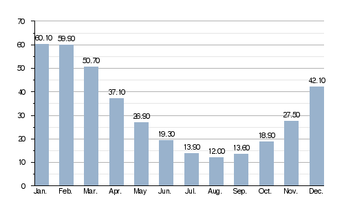
Average monthly water flow (cubic meters per second) at Durtal
This chart shows how the amount of water in the Loir changes throughout the year. You can see it's highest in winter and spring, and lowest in summer.
Where the Loir Begins and Ends
The Loir river starts in a historical area called Perche. Its exact starting point is in a small town named Champrond-en-Gâtine in the Eure-et-Loir department. It begins high up, at about 265 metres (869 feet) above sea level.
From there, the Loir generally flows towards the southwest. It travels through many towns and villages across different regions of France.
Towns Along the Loir
The Loir flows through these areas and towns:
- In the Centre-Val de Loire region:
- Eure-et-Loir department: Châteaudun, Bonneval, Cloyes-sur-le-Loir, and others.
- Loir-et-Cher department: Vendôme, Lavardin, Montoire-sur-le-Loir, and more.
- In the Pays de la Loire region:
- Sarthe department: La Flèche, Château-du-Loir, Le Lude, and others.
- Maine-et-Loire department: Durtal, Seiches-sur-le-Loir, Briollay, and more.
The Loir finishes its journey by joining the Sarthe river. This meeting point is called Bec du Loir (which means "beak of the Loir") and is located in Briollay, Maine-et-Loire. Here, the river is much lower, at about 16 metres (52 feet) above sea level.
Rivers Joining the Loir
Many smaller rivers and streams flow into the Loir. These are called tributaries. They add water to the Loir as it makes its way to the Sarthe river.
|
Rivers joining from the left:
|
Rivers joining from the right:
|
Gallery


.jpg)
.jpg)
Related pages
See also
 In Spanish: Río Loir para niños
