
La Flèche facts for kids
Quick facts for kids
La Flèche
|
||
|---|---|---|
 |
||
|
||

La Flèche
Location in France

La Flèche
Location in Pays de la Loire
|
||
| Country | France | |
| Region | Pays de la Loire | |
| Department | Sarthe | |
| Arrondissement | La Flèche | |
| Canton | La Flèche | |
| Intercommunality | Pays Fléchois | |
| Area
1
|
74.21 km2 (28.65 sq mi) | |
| Population
(2006)
|
16,428 | |
| • Density | 221.372/km2 (573.35/sq mi) | |
| Time zone | UTC+01:00 (CET) | |
| • Summer (DST) | UTC+02:00 (CEST) | |
| INSEE/Postal code |
72154 /72200
|
|
| Elevation | 23–103 m (75–338 ft) (avg. 33 m or 108 ft) |
|
| 1 French Land Register data, which excludes lakes, ponds, glaciers > 1 km2 (0.386 sq mi or 247 acres) and river estuaries. | ||
.svg)
La Flèche is a charming town, also known as a commune, located in the western part of France. It's found in the region called Pays de la Loire, within the Sarthe department. This town is known for its rich history and interesting places to visit.
Contents
Discovering La Flèche
La Flèche is a lovely place with a mix of old traditions and modern life. It sits by the Loir River, which adds to its beauty. The town is a subprefecture, meaning it's an important administrative center for its area.
Where is La Flèche?
La Flèche is located in the western part of France. It's part of the Pays de la Loire region. This region is famous for its beautiful castles and green landscapes. The town is also in the Sarthe department. This department is named after the Sarthe River.
A Glimpse into History
La Flèche has a long and interesting history. It was once an important town in the Anjou region. Over the centuries, it has seen many changes. One of its most famous historical sites is the Prytanée National Militaire. This is a military school with a very old past. It was originally founded as a Jesuit college in the 17th century. Many famous people studied here, including the philosopher René Descartes.
The Jesuit College
The Jesuit College was a very important school. It was built in the early 1600s. The college aimed to provide a great education. It attracted students from all over France. The beautiful buildings of the college still stand today. They show the amazing architecture of that time.
Fun Places to Visit
La Flèche offers several exciting attractions for visitors. Whether you love history, animals, or just a nice walk, there's something for everyone.
The La Flèche Zoo
One of the most popular spots is the Zoological Park of La Flèche. It is one of the oldest and most famous zoos in France. Here you can see many different animals from all over the world. The zoo is known for its efforts to protect endangered species. It's a great place to learn about wildlife.
The Loir River
The Loir River flows right through La Flèche. It offers beautiful scenery and opportunities for walks. You can enjoy the peaceful atmosphere along the riverbanks. It's a perfect spot for a relaxing afternoon.
Local Landmarks
The town also has several other notable buildings. The Pavillon Fouquet de La Varenne is a historic mansion. It shows the grand style of past centuries. The Eglise St Louis is a beautiful church. It was part of the old Jesuit college. These buildings tell the story of La Flèche's rich heritage.
Life in La Flèche
Today, La Flèche is a lively town. It has a population of over 16,000 people. The town offers schools, shops, and local services. It is a center for the surrounding rural area. The local government, led by the mayor, helps manage the town. They work to make La Flèche a great place to live.
Local Economy
The economy of La Flèche includes farming and small businesses. Tourism is also important, thanks to the zoo and historical sites. The town works to support its local industries. It also tries to attract new businesses.
Community Life
The people of La Flèche enjoy a strong sense of community. There are local events and markets. These events bring people together. The town is a mix of old traditions and new ideas. It offers a pleasant lifestyle for its residents.
Images for kids
-
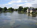
The Loir River in La Flèche
-
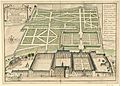
The Jesuit College in La Flèche (1695)
-
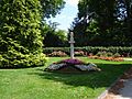
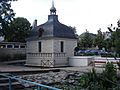
Carmes' Park
-
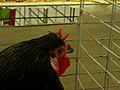
La Flèche "Black Chicken"
-
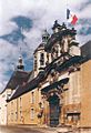
Entrance to the Prytanée National Militaire
-

Polar Bear at the Zoological Park of La Flèche
-
Pavillon Fouquet de La Varenne in La Flèche
-
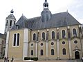
Saint Louis Church in La Flèche (from the Jesuit college)

.jpg)


.JPG)
See also
 In Spanish: La Flèche para niños
