
Indre-et-Loire facts for kids
Quick facts for kids
Indre-et-Loire
|
|||
|---|---|---|---|

Prefecture building of the Indre-et-Loire department, in Tours
|
|||
|
|||

Location of Indre-et-Loire in France
|
|||
| Country | France | ||
| Region | Centre-Val de Loire | ||
| Département | 4 March 1790 | ||
| Prefecture | Tours | ||
| Subprefectures | Chinon, Loches | ||
| Area | |||
| • Total | 6,126.7 km2 (2,365.5 sq mi) | ||
| Population
(2013)
|
|||
| • Total | 600,252 | ||
| • Density | 97.9731/km2 (253.7493/sq mi) | ||
| Time zone | UTC+1 (CET) | ||
| • Summer (DST) | UTC+2 (CEST) | ||
| ISO 3166 code | FR-37 | ||
| Arrondissements | 3 | ||
| Cantons | 19 | ||
| Communes | 277 | ||


Indre-et-Loire is a special area in west-central France. It is called a department. Its name comes from two important rivers: the Indre and the Loire.
The main city and administrative center of Indre-et-Loire is Tours. This city is known as the prefecture of the department.
Contents
History of Indre-et-Loire
Indre-et-Loire was one of the very first 83 departments created in France. This happened during the French Revolution on March 4, 1790. The city of Tours was chosen as its capital.
This new department was formed from a part of an older area called Touraine. At first, it was divided into seven smaller areas called districts. These were Tours, Amboise, Château-Renault, Loches, Chinon, Preuilly, and Langeais.
In 1800, France changed how its areas were organized. The seven districts became three larger areas called arrondissements. These new arrondissements were Chinon, Loches, and Tours.
Later, in 1926, the arrondissement of Loches was removed. But in 1943, it was made an arrondissement again.
Geography of Indre-et-Loire
Indre-et-Loire is located in the Centre-Val de Loire region of France. It covers an area of about 6,126.7 square kilometers (2,365.5 square miles).
The department is surrounded by five other departments. These departments belong to three different regions:
- Centre-Val de Loire region:
- Loir-et-Cher department (to the northeast)
- Indre department (to the southeast)
- Nouvelle-Aquitaine region:
- Vienne department (to the southwest)
- Pays de la Loire region:
- Maine-et-Loire department (to the west)
- Sarthe department (to the north)
 |
Sarthe | Loir-et-Cher | |
|
| Maine-et-Loire | ||||
| Vienne | Indre |
The highest point in Indre-et-Loire is called Signal de la Ronde. It is 186 meters (610 feet) high. This point is in the town of Céré-la-Ronde, near the border with the Loir-et-Cher department.
The famous Loire river flows right through the middle of the department. Other important rivers like the Indre, Cher, and Vienne also flow here. They all eventually join the Loire river within Indre-et-Loire.
Climate in Indre-et-Loire
The climate in Indre-et-Loire usually does not have extreme temperatures. It is known as a "Marine West Coast Climate" (Cfb). This means it has mild winters and warm summers.
On average, the department gets about 696 millimeters (27.4 inches) of precipitation each year. October is usually the wettest month, with about 71.1 mm (2.8 inches) of rain. August is the driest month, with only about 43.2 mm (1.7 inches) of rain.
The average temperature for the whole year in Tours is 11.8°C (53.2°F). July is the warmest month, with an average temperature of 19.8°C (67.6°F). January is the coolest month, with an average temperature of 4.7°C (40.5°F).
| Climate data for Tours, France | |||||||||||||
|---|---|---|---|---|---|---|---|---|---|---|---|---|---|
| Month | Jan | Feb | Mar | Apr | May | Jun | Jul | Aug | Sep | Oct | Nov | Dec | Year |
| Mean daily maximum °C (°F) | 4.7 (40.5) |
5.2 (41.4) |
8.1 (46.6) |
10.4 (50.7) |
14.2 (57.6) |
17.5 (63.5) |
19.8 (67.6) |
19.6 (67.3) |
16.5 (61.7) |
12.7 (54.9) |
7.8 (46.0) |
5 (41) |
11.8 (53.2) |
| Daily mean °C (°F) | 7.3 (45.1) |
8.5 (47.3) |
12.3 (54.1) |
15.2 (59.4) |
19.1 (66.4) |
22.8 (73.0) |
25.5 (77.9) |
25.4 (77.7) |
21.8 (71.2) |
16.8 (62.2) |
10.9 (51.6) |
7.5 (45.5) |
16.1 (61.0) |
| Mean daily minimum °C (°F) | 2 (36) |
1.9 (35.4) |
3.9 (39.0) |
5.6 (42.1) |
9.2 (48.6) |
12.1 (53.8) |
14 (57) |
13.7 (56.7) |
11.1 (52.0) |
8.6 (47.5) |
4.6 (40.3) |
2.5 (36.5) |
7.4 (45.4) |
| Average rainfall mm (inches) | 66.2 (2.61) |
55.8 (2.20) |
50.3 (1.98) |
55.8 (2.20) |
62.3 (2.45) |
46.1 (1.81) |
53.2 (2.09) |
42.5 (1.67) |
53.2 (2.09) |
70.9 (2.79) |
68 (2.7) |
71.3 (2.81) |
695.6 (27.4) |
| Source: Weatherbase.com [1] | |||||||||||||
Administration of Indre-et-Loire
Indre-et-Loire is governed by the General Council of Ardennes. This council is located in the city of Tours. The department is part of the Centre-Val de Loire region.
Administrative Divisions
The department of Indre-et-Loire is divided into smaller administrative areas. These help manage the region.
- There are 3 arrondissements (which are like large districts).
- There are 19 cantons (smaller groups of towns).
- There are 277 communes (which are like individual towns or municipalities).
Here is a table showing the arrondissements of Indre-et-Loire:
| INSEE code |
Arrondissement | Capital | Population (2013) |
Area (km²) |
Density (Inh./km²) |
Communes |
|---|---|---|---|---|---|---|
| 371 | Chinon | Chinon | 86,706 | 1,694.2 | 51.2 | 87 |
| 372 | Tours | Tours | 462,714 | 2,629.2 | 176.0 | 123 |
| 373 | Loches | Loches | 50,832 | 1,803.4 | 28.2 | 67 |
Here are the 19 cantons in Indre-et-Loire. These were reorganized in March 2015:
- Amboise
- Ballan-Miré
- Bléré
- Château-Renault
- Chinon
- Descartes
- Joué-lès-Tours
- Langeais
- Loches
- Montlouis-sur-Loire
- Monts
- Saint-Cyr-sur-Loire
- Sainte-Maure-de-Touraine
- Saint-Pierre-des-Corps
- Tours-1
- Tours-2
- Tours-3
- Tours-4
- Vouvray
People of Indre-et-Loire
The people who live in the Indre-et-Loire department are called Tourangeaux (for men) or Tourangelles (for women) in French.
In 2013, the department had a population of 600,252 people. This means there were about 98 inhabitants for every square kilometer. The arrondissement of Tours is the most populated, with 462,714 people living there.
Here are the communes (towns) in the department that have more than 10,000 inhabitants:
| City | Population (2013) |
Arrondissement |
|---|---|---|
| Tours | 134,803 | Tours |
| Joué-lès-Tours | 37,703 | Tours |
| Saint-Cyr-sur-Loire | 16,239 | Tours |
| Saint-Pierre-des-Corps | 15,404 | Tours |
| Saint-Avertin | 14,893 | Tours |
| Amboise | 13,246 | Tours |
| Chambray-lès-Tours | 10,881 | Tours |
| Montlouis-sur-Loire | 10,787 | Tours |
| Fondettes | 10,193 | Tours |
| La Riche | 10,276 | Tours |
Gallery
-
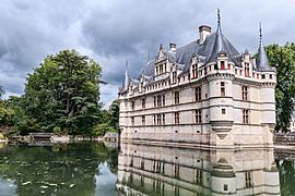
Château d'Azay-le-Rideau
-

Château d'Amboise
-

Montrésor


Related pages
Images for kids
-

Tours Cathedral

See also
 In Spanish: Indre y Loira para niños
