
Haute-Vienne facts for kids
Quick facts for kids
Haute-Vienne
|
||
|---|---|---|

Prefecture building of the Haute-Vienne department, in Limoges
|
||
|
||

Location of Haute-Vienne in France
|
||
| Country | France | |
| Region | Nouvelle-Aquitaine | |
| Département | 4 March 1790 | |
| Prefecture | Limoges | |
| Subprefectures | Bellac, Rochechouart | |
| Area | ||
| • Total | 5,520.1 km2 (2,131.3 sq mi) | |
| Population
(2014)
|
||
| • Total | 376,199 | |
| • Density | 68.1508/km2 (176.5097/sq mi) | |
| Demonym(s) | Haut-Viennois | |
| Time zone | UTC+1 (CET) | |
| • Summer (DST) | UTC+2 (CEST) | |
| ISO 3166 code | FR-87 | |
| Arrondissements | 3 | |
| Cantons | 21 | |
| Communes | 200 | |
| Website | www.haute-vienne.fr | |

Haute-Vienne (pronounced "Oht-Vyen") is a special area in France. It's like a county or state, called a department. It's part of the Nouvelle-Aquitaine region. The department gets its name from the Vienne River, which flows right through it.
Contents
History of Haute-Vienne
Haute-Vienne is one of the first 83 French departments. It was created during the French Revolution on March 4, 1790. This new area was formed from parts of older regions. These included the southern half of Limousin and the northern half of Marche. Some small parts of Angoumois and Poitou were also included.
At first, the department was divided into six smaller areas called districts. These were Limoges, Le Dorat, Bellac, Saint-Junien, Saint-Yrieix, and Saint-Léonard. The main city, or prefecture, was Limoges.
In 1800, France changed its administrative system. The six districts became four arrondissements: Limoges, Bellac, Rochechouart, and Saint-Yrieix. Later, in 1926, the Saint-Yrieix arrondissement was removed.
Geography and Landscape
Haute-Vienne is located in the Nouvelle-Aquitaine region of France. It covers an area of about 5,520 square kilometers (2,131 square miles).
The department shares its borders with six other departments. These departments are in two different regions:
- Nouvelle-Aquitaine region:
- Centre-Val de Loire region:
 |
Vienne | Indre | |
|
| Charente | Creuse | |||
| Dordogne | Corrèze |
Haute-Vienne is on the northwestern edge of the Massif Central. This is a large area of mountains and high land in central France. The department's elevation ranges from about 160 meters (520 feet) to 750 meters (2,460 feet) above sea level. The lowest point is in the valley of the Vienne River. The highest point is near the Vassivière lake. The very highest spot is Puy de Crozat, which is 777 meters (2,549 feet) high.
The main rivers in the department are the Vienne River and the Gartempe. The Vienne River gives the department its name. The Gartempe is a river that flows into the Creuse River.
Climate in Haute-Vienne
The climate in Limoges, the main city, is an oceanic climate. This means it has mild summers and no dry season. It's known as a Cfb climate in the Köppen climate classification system.
On average, Limoges gets about 726.4 millimeters (28.6 inches) of rain each year. October is usually the wettest month, with about 86.4 millimeters (3.4 inches) of rain. February is the driest month, with about 45.7 millimeters (1.8 inches) of rain.
The average temperature in Limoges for the whole year is 11.4 °C (52.5 °F). July is the warmest month, with an average temperature of 19.3 °C (66.7 °F). January is the coolest month, with an average temperature of 4.2 °C (39.6 °F).
How Haute-Vienne is Governed
The department of Haute-Vienne is managed by the Departmental Council of the Haute-Vienne. This council is located in Limoges. Haute-Vienne is part of the larger Nouvelle-Aquitaine region.
Administrative Divisions
Haute-Vienne is divided into several smaller areas. There are 3 arrondissements (which are like large districts). These are further divided into 21 cantons. The smallest divisions are 200 communes, which are like towns or municipalities.
Here is a table showing the main arrondissements:
| INSEE code |
Arrondissement | Capital | Population (2014) |
Area (km²) |
Density (Inh./km²) |
Communes |
|---|---|---|---|---|---|---|
| 871 | Bellac | Bellac | 39,744 | 1,779.9 | 22.3 | 62 |
| 872 | Limoges | Limoges | 298,578 | 2,944.8 | 101.4 | 108 |
| 873 | Rochechouart | Rochechouart | 37,877 | 795.4 | 47.6 | 30 |
The department also has 21 cantons. These are smaller areas used for elections and local administration. They were reorganized in March 2015.
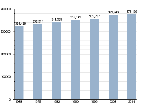
Population of Haute-Vienne
The people who live in Haute-Vienne are called Haut-Viennois (for men) or Haut-Viennoises (for women) in French.
In 2013, Haute-Vienne had a population of 376,199 people. This means there were about 68.1 people living per square kilometer (176 people per square mile). The arrondissement of Limoges is the largest by far, with 298,578 people. The other two, Bellac and Rochechouart, have populations of 39,744 and 37,877 respectively.
How the Population of Haute-Vienne Has Changed
Here are the 10 largest cities in the department by population:
| City | Population (2014) |
Arrondissement |
|---|---|---|
| Limoges | 134,577 | Limoges |
| Saint-Junien | 11,196 | Rochechouart |
| Panazol | 10,734 | Limoges |
| Couzeix | 8,955 | Limoges |
| Isle | 7,520 | Limoges |
| Saint-Yrieix-la-Perche | 6,848 | Limoges |
| Feytiat | 6,147 | Limoges |
| Le Palais-sur-Vienne | 6,069 | Limoges |
| Aixe-sur-Vienne | 5,771 | Limoges |
| Ambazac | 5,628 | Limoges |
Gallery
-
Abbaye de la Règle, Limoges
-
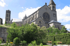
Saint-Yrieix-la-Perche
-
Maisonnais-sur-Tardoire
-
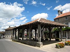
Mortemart


Related pages
Images for kids
-
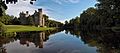
Château de Montbrun
-
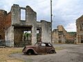
Ruins of Oradour-sur-Glane
-
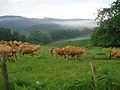
Limousin cows near Saint-Laurent-les-Églises
-
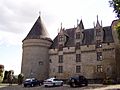
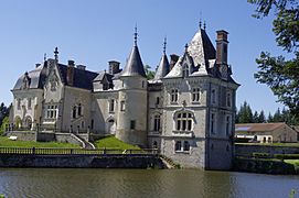
Château de Rochechouart
.jpg)

,_paysage_matinal.JPG)

See also
 In Spanish: Alto Vienne para niños
