
Charente facts for kids
Quick facts for kids
Charente
|
|||
|---|---|---|---|

Prefecture building of the Charente department, in Angoulême
|
|||
|
|||

Location of Charente in France
|
|||
| Country | France | ||
| Region | Nouvelle-Aquitaine | ||
| Département | 4 March 1790 | ||
| Prefecture | Angoulême | ||
| Subprefectures | Cognac, Confolens | ||
| Area | |||
| • Total | 5,956 km2 (2,300 sq mi) | ||
| Population
(2014)
|
|||
| • Total | 353,853 | ||
| • Density | 59.411/km2 (153.874/sq mi) | ||
| Demonym(s) | Charentais | ||
| Time zone | UTC+1 (CET) | ||
| • Summer (DST) | UTC+2 (CEST) | ||
| ISO 3166 code | FR-16 | ||
| Arrondissements | 3 | ||
| Cantons | 19 | ||
| Communes | 383 | ||
| Website | http://www.lacharente.fr | ||


Charente is a special area in southwestern France. It is called a department. You can find it in the Nouvelle-Aquitaine region.
This department gets its name from the Charente river. This river is very important to the area. The two biggest towns, Angoulême and Cognac, are located along this river.
Contents
History of Charente: How it Became a Department
Charente was created during the French Revolution. This happened on March 4, 1790. It was formed from an old province called Angoumois. This area was centered around the city of Angoulême.
When it was first made, Charente had six smaller areas called districts. These were Ruffec, Confolens, La Rochefoucauld, Angoulême, Barbezieux, and Cognac. Angoulême was chosen as the main city, or prefecture.
In 1800, the districts were changed into five arrondissements. These new areas were Angoulême, Barbezieux, Cognac, Confolens, and Ruffec. Later, in 1926, the arrondissements of Barbezieux and Ruffec were removed.
Geography of Charente: Land, Rivers, and Climate
Charente is part of the Nouvelle-Aquitaine region. It covers an area of about 5,956 square kilometers (2,299 square miles).
The highest point in Charente is Rocher aux Oiseaux. It is 368 meters (1,207 feet) high. The lowest point is only 8 meters (26 feet) high. This low point is in the Charente river valley near Merpins.
Charente shares borders with several other departments. These include Deux-Sèvres, Vienne, Haute-Vienne, Dordogne, and Charente-Maritime.
 |
Deux-Sèvres | Vienne | |
|
| Charente-Maritime | Haute-Vienne | |||
| Charente-Maritime | Dordogne | Dordogne |
The main river in the department is the Charente. Other important rivers are the Dronne and the Vienne.
Climate in Charente: Weather Patterns
The climate in Charente, especially around Cognac, is an oceanic climate. This means it has mild summers. It is classified as Cfb in the Köppen climate classification.
The area gets about 777.2 millimeters (30.6 inches) of rain each year. November is usually the wettest month. July is the driest month.
The average yearly temperature in Cognac is 13.3°C (55.9°F). July is the warmest month, with an average of 21.1°C (70.0°F). January is the coolest month, averaging 6.1°C (43.0°F).
Administration of Charente: How it is Governed
The department is run by the Departmental Council of the Charente. This council is based in Angoulême. Charente is part of the larger Nouvelle-Aquitaine region.
Administrative Divisions: Arrondissements, Cantons, and Communes
Charente is divided into three main areas called arrondissements. It also has 19 cantons and 383 communes (which are like small towns or villages).
Here is a quick look at the arrondissements:
| INSEE code |
Arrondissement | Capital | Population (2014) |
Area (km²) |
Density (Inh./km²) |
Communes |
|---|---|---|---|---|---|---|
| 161 | Angoulême | Angoulême | 197,377 | 2,217.1 | 89.0 | 117 |
| 162 | Cognac | Cognac | 92,224 | 1,471.2 | 62.7 | 116 |
| 163 | Confolens | Confolens | 64,252 | 2,267.7 | 28.3 | 150 |
The 19 cantons of Charente were reorganized in March 2015. Here they are:
- Angoulême-1 (1601)
- Angoulême-2 (1602)
- Angoulême-3 (1603)
- Boëme-Échelle (1604)
- Boixe-et-Manslois (1605)
- Charente-Bonnieure (1606)
- Charente-Champagne (1607)
- Charente-Nord (1608)
- Charente-Sud (1609)
- Charente-Vienne (1610)
- Cognac-1 (1611)
- Cognac-2 (1612)
- La Couronne (1613)
- Gond-Pontouvre (1614)
- Jarnac (1615)
- Touvre-et-Braconne (1616)
- Tude-et-Lavalette (1617)
- Val de Nouère (1618)
- Val de Tardoire (1619)
Demographics: People of Charente
The people who live in Charente are called Charentais (for men) or Charentaises (for women) in French.
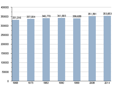
In 2014, Charente had 353,853 people living there. This means there were about 59.4 people per square kilometer. The arrondissement of Angoulême is the largest, with 197,377 people. Cognac has 92,224 people, and Confolens has 64,252.
How the Population of Charente Has Changed Over Time
Here are the 10 largest cities in the department:
| City | Population (2014) |
Arrondissement |
|---|---|---|
| Angoulême | 41,955 | Angoulême |
| Cognac | 18,717 | Cognac |
| Soyaux | 9,322 | Angoulême |
| La Couronne | 7,636 | Angoulême |
| Ruelle-sur-Touvre | 7,292 | Angoulême |
| Saint-Yrieix-sur-Charente | 7,210 | Angoulême |
| Gond-Pontouvre | 5,907 | Angoulême |
| L' Isle-d'Espagnac | 5,412 | Angoulême |
| Champniers | 5,251 | Angoulême |
| Barbezieux-Saint-Hilaire | 4,730 | Cognac |
Economy: The Famous Cognac Drink
The most famous product from Charente is cognac. This is a type of brandy, which is an alcoholic drink. It is made from grapes. Most cognac is produced around the city of Cognac.
Gallery
-
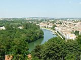
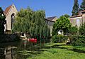
The Charente river in Angoulême
-
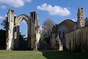
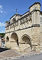
Abbey of La Couronne
-
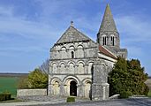
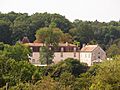
Plassac-Rouffiac


Related pages
Images for kids
-
Champagne-Vigny
-
Verteuil-sur-Charente
-
Aubeterre-sur-Dronne
-
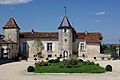
Château de la Faye


See also
 In Spanish: Charente para niños
