
Charente (river) facts for kids
Quick facts for kids Charente |
|
| River | |
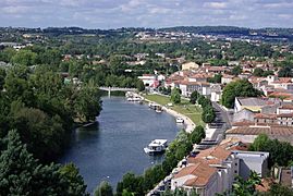
 The Charente in Tonnay-Charente
|
|
| Country | France |
|---|---|
| Region | Nouvelle-Aquitaine |
| Departments | Haute-Vienne, Vienne, Charente, Charente-Maritime |
| Communes | Saint-Yrieix-sur-Charente, Jarnac, Tonnay-Charente, Angoulême, Cognac, Tonnay-Charente, Rochefort |
| Tributaries | |
| - left | Bonnieure, Né, Seugne |
| - right | Antenne, Boutonne |
| Cities | Angoulême, Cognac, Jarnac, Saintes, Rochefort |
| Source | Chéronnac |
| - location | Massif Central, Nouvelle-Aquitaine, France |
| - elevation | 308 m (1,010 ft) |
| - coordinates | 45°45′21″N 0°46′15″E / 45.75583°N 0.77083°E |
| Mouth | Atlantic Ocean |
| - location | Rochefort, Nouvelle-Aquitaine, France |
| - elevation | 0 m (0 ft) |
| - coordinates | 45°57′15″N 1°04′32″W / 45.95417°N 1.07556°W |
| Length | 381.4 km (237 mi) |
| Basin | 9,855 km² (3,805 sq mi) |
| Discharge | for Chaniers |
| - average | 49 m³/s (1,730 cu ft/s) |
The Charente is a river in southwestern France. It flows through the Nouvelle-Aquitaine region. You might notice that two areas, called Charente and Charente-Maritime, are even named after this river!
The Charente River starts in the Massif Central mountains. It then flows all the way to the Atlantic Ocean. It reaches the ocean near the city of Rochefort. The part of the Atlantic Ocean it flows into is called the Bay of Biscay.
Contents
Exploring the Charente River's Journey
The Charente River is about 381.4 kilometers (237 miles) long. Imagine walking that far! The area of land that drains into the river is huge. It covers about 9,855 square kilometers (3,805 square miles). This area is called its drainage basin.
Where Does the Charente River Start?
The Charente River begins in the western part of the Massif Central mountains. This is in a small town called Chéronnac. It's located in the Haute-Vienne department of France. The river starts at a height of about 308 meters (1,010 feet) above sea level.
How Does the River Flow?
First, the river flows northwest for about 12 kilometers (7.5 miles). Then, it goes through the northern part of the Charente department. It continues flowing northwest and enters the Vienne department.
After passing the town of Civray, the river changes direction. It turns southwest and goes back into the Charente department. Once it flows past Angoulême, it turns west. After Cognac, it turns northwest again.
Finally, the Charente River reaches the Atlantic Ocean. This happens near the city of Rochefort.
Can Boats Travel on the Charente?
Yes, parts of the Charente River are navigable. This means it's deep, wide, and calm enough for boats to travel on it. Most of the boats you'll see are for fun and recreation. People enjoy boating from Angoulême all the way to where the river meets the ocean.
Regions and Cities Along the River
The Charente River flows through four different departments in the Nouvelle-Aquitaine region. It passes by 120 different towns and cities!
- Haute-Vienne: The river starts here and flows through three towns.
- Vienne: It goes through ten towns, including Charroux and Civray.
- Charente: This is where the river spends most of its journey. It flows through 78 towns. Important cities here include Angoulême, Jarnac, and Cognac.
- Charente-Maritime: The river passes through 35 towns in this department. It flows by cities like Saintes, Tonnay-Charente, and Rochefort.
Main Rivers Joining the Charente
Many smaller rivers flow into the Charente. These are called tributaries. They add water to the main river.
Here are some of the most important tributaries:
|
Rivers joining from the left:
|
Rivers joining from the right:
|
Gallery
-
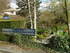
The source of the Charente in Cheronnac
-
The Charente in Houmeau, near Angoulême
-
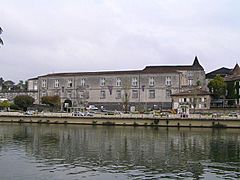
The Charente River and the historic Château de Cognac
-
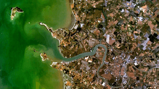
The mouth of the Charente River where it meets the ocean


Related pages
See also
 In Spanish: Río Charente para niños
