
Confolens facts for kids
Quick facts for kids
Confolens
|
||
|---|---|---|

View of Confolens from the Sainte-Catherine hill
|
||
|
||

Confolens
Location in France

Confolens
Location in Nouvelle-Aquitaine
|
||
| Country | France | |
| Region | Nouvelle-Aquitaine | |
| Department | Charente | |
| Arrondissement | Confolens | |
| Canton | Charente-Vienne | |
| Intercommunality | Confolentais | |
| Area
1
|
23.63 km2 (9.12 sq mi) | |
| Population
(2013)
|
2,721 | |
| • Density | 115.15/km2 (298.24/sq mi) | |
| Demonym(s) | Confolentais | |
| Time zone | UTC+01:00 (CET) | |
| • Summer (DST) | UTC+02:00 (CEST) | |
| INSEE/Postal code |
16106 /16500
|
|
| Elevation | 127–222 m (417–728 ft) (avg. 152 m or 499 ft) |
|
| Website | www.mairie-confolens.fr | |
| 1 French Land Register data, which excludes lakes, ponds, glaciers > 1 km2 (0.386 sq mi or 247 acres) and river estuaries. | ||
.svg)
Confolens (which means "Confolents" in the Occitan language) is a small town in southwestern France. It's a very important place for the area around it, which is mostly countryside. In recent years, more and more people have been visiting Confolens as tourists.
Confolens is one of the two main administrative centers, called "subprefectures," in the Charente region. It is also the main town of the Charente-Vienne area.
Contents
History of Confolens
On January 1, 2016, a nearby town called Saint-Germain-de-Confolens joined with Confolens. This means they became one bigger town.
Where is Confolens?
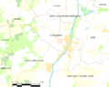
Confolens is special because it sits right where two rivers meet. These rivers are the Vienne and the Goire. The town's name, Confolens, comes from a Latin word, confluens, which means "confluence" or "where rivers meet."
The town is about 65 kilometers (40 miles) from Angoulême. It is also 55 kilometers (34 miles) from Limoges and 70 kilometers (43 miles) from Poitiers. These are the three biggest cities closest to Confolens.
Confolens covers an area of about 23.63 square kilometers (9.12 square miles). The average height of the town above sea level is 152 meters (499 feet). Right at the town hall, the height is 150 meters (492 feet).
The towns that are close to Confolens include Brillac, Esse, Saint-Maurice-des-Lions, Ansac-sur-Vienne, Hiesse, and Lessac.
What's the Weather Like?
Confolens has a type of weather called an Oceanic climate. This means it usually has mild winters and warm, but not too hot, summers.
People in Confolens
Confolens has a population of 2,721 people. This means there are about 115 people living in each square kilometer of the town.
The people who live in Confolens are called Confolentais (for men) or Confolentaises (for women) in French.
Town Government
Since the year 1800, Confolens has been an important administrative center. It is a "subprefecture" for the Charente department. It is also the main town for the Charente-Vienne area.
Famous People from Confolens
- Émile Roux (1853-1933) was a very important medical doctor and scientist. He studied tiny living things like bacteria. He worked closely with the famous scientist Louis Pasteur.
Twin Towns
Confolens has special friendships with two other towns around the world. These are called "twin towns":
 Pitlochry, in Scotland, has been a twin town since 2007.
 Georgenthal, in Germany, has also been a twin town since 2007.
Images for kids
-
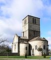
Saint Barthélemy church
-
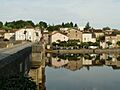
Pont-Vieux
-
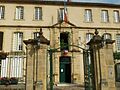
Town hall
-
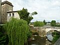
Bridge over the Goire river
-
Map of Confolens and its surrounding area


Related Articles
See also
 In Spanish: Confolens para niños
