Arrondissement of Rochefort facts for kids
Quick facts for kids
Arrondissement of Rochefort
|
|
|---|---|

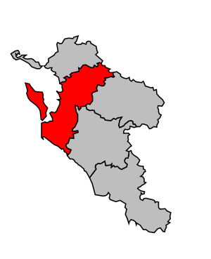
Location of Rochefort in Charente-Maritime
|
|
| Country | France |
| Region | Nouvelle-Aquitaine |
| Department | Charente-Maritime |
| Communes | 82 |
| Subrefecture | Rochefort |
| INSEE code | 172 |
| Area | |
| • Total | 1,527.5 km2 (589.8 sq mi) |
| Population
(2014)
|
|
| • Total | 187,843 |
| • Density | 122.974/km2 (318.502/sq mi) |
The arrondissement of Rochefort is like a special administrative area in France. Think of it as a big district or region within a larger department. Its main city, or "capital," is Rochefort. This arrondissement is located in the Charente-Maritime department, which is part of the Nouvelle-Aquitaine region in France.
Contents
History of Rochefort Arrondissement
When the Charente-Maritime department was first created in 1790, the Rochefort area was already one of its original districts. It has been an important part of the department's history ever since.
Geography and Location
The Rochefort arrondissement covers about 1,527.5 square kilometers (that's about 589.8 square miles). In 2014, it had a population of 187,843 people. This means there were about 123 people living in each square kilometer.
Rochefort is located in the northern part of the Charente-Maritime department. To its north, you'll find the La Rochelle arrondissement. To the northeast, it borders the Deux-Sèvres department. On its eastern side are the Saint-Jean-d'Angély and Saintes arrondissements.
To the south, you'll find the upper part of the Gironde estuary. This is the largest estuary in France, where a river meets the sea. To the west, the arrondissement meets the Atlantic Ocean.
How Rochefort is Organized
The arrondissement of Rochefort is made up of smaller areas called communes. Think of communes as towns or villages. There are 82 communes in total within this arrondissement.
Cantons in Rochefort
Cantons are another way France organizes its areas. They are groups of communes. After some changes in France, cantons can now include communes from different arrondissements.
In the Rochefort arrondissement, there are 12 cantons. Some of these cantons are only partly within Rochefort. The table below shows how the communes are spread out among the cantons and different arrondissements:
| INSEE Code |
Canton | Arrondissements | Total | ||||
|---|---|---|---|---|---|---|---|
| Jonzac | Rochefort | La Rochelle | Saintes | Saint-Jean-d'Angély | |||
| 1703 | Châtelaillon-Plage | 3 | 5 | 8 | |||
| 1704 | Île d'Oléron | 8 | 8 | ||||
| 1706 | La Jarrie | 2 | 12 | 14 | |||
| 1710 | Marennes | 14 | 14 | ||||
| 1713 | Rochefort | 1 | 1 | ||||
| 1717 | Royan | 3 | 3 | ||||
| 1718 | Saint-Jean-d'Angély | 3 | 2 | 37 | 42 | ||
| 1721 | Saintonge Estuaire | 1 | 23 | 24 | |||
| 1722 | Saujon | 2 | 7 | 9 | |||
| 1723 | Surgères | 21 | 21 | ||||
| 1725 | Tonnay-Charente | 15 | 15 | ||||
| 1726 | La Tremblade | 9 | 9 | ||||
Main Communes
While there are 82 communes, some are much larger than others. Here are the communes with the most people living in them (based on 2014 data):
| INSEE code |
Commune | Population (2014) |
Canton | Intercommunality |
|---|---|---|---|---|
| 17299 | Rochefort | 24,300 | Rochefort | CA Rochefort Océan |
| 17306 | Royan | 18,388 | Royan | CA Royan Atlantique |
| 17449 | Tonnay-Charente | 7,926 | Tonnay-Charente | CA Rochefort Océan |
| 17434 | Surgères | 6,713 | Surgères | Aunis Sud |
| 17385 | Saint-Pierre-d'Oléron | 6,694 | L’Île d'Oléron | L’Île d'Oléron |
| 17219 | Marennes | 5,672 | Marennes | Bassin de Marennes |
| 17333 | Saint-Georges-de-Didonne | 5,181 | Royan | CA Royan Atlantique |
| 17452 | La Tremblade | 4,792 | La Tremblade | CA Royan Atlantique |
| 17093 | Le Château-d'Oléron | 4,063 | L’Île d'Oléron | L’Île d'Oléron |
| 17168 | Fouras | 4,047 | Châtelaillon-Plage | CA Rochefort Océan |
See also
See also
 In Spanish: Distrito de Rochefort para niños
 | John T. Biggers |
 | Thomas Blackshear |
 | Mark Bradford |
 | Beverly Buchanan |

