
Ariège (river) facts for kids
Quick facts for kids Ariège |
|
| River | |
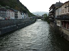
 Ariège river in Tarascon-sur-Ariège
|
|
| Countries | Andorra, France |
|---|---|
| Region | Occitanie |
| Departments | Pyrénées-Orientales, Ariège, Haute-Garonne |
| Tributaries | |
| - left | Aston, Vicdessos, Courbière, Lèze |
| - right | Oriège, Lauze, Crieu, Hers-Vif, Aïse |
| Cities | Foix, Pamiers |
| Source | Lac Noire, Pyrenees |
| - location | Porta, Pyrénées-Orientales, France |
| - elevation | 2,470 m (8,104 ft) |
| - coordinates | 42°31′9″N 1°44′21″E / 42.51917°N 1.73917°E |
| Confluence | Garonne |
| - location | Portet-sur-Garonne, Haute-Garonne, France |
| - elevation | 140 m (459 ft) |
| - coordinates | 43°31′2″N 1°24′36″E / 43.51722°N 1.41000°E |
| Length | 163.2 km (101 mi) |
| Basin | 4,135 km² (1,597 sq mi) |
| Discharge | for Pinsaguel |
| - average | 76.4 m³/s (2,698 cu ft/s) |
The Ariège (Catalan: Arieja; Occitan: Arièja) is a river in the south of France. It is about 163 kilometers (101 miles) long. This river is a right tributary of the Garonne. This means it flows into the Garonne from the right side. The Ariège department is even named after this important river!
Contents
About the Ariège River
The Ariège river stretches for about 163.2 kilometers (101.4 miles). The area of land where all the water drains into the river is called its drainage basin. For the Ariège, this area covers about 4,135 square kilometers (1,597 square miles).
How Much Water Flows?
The amount of water flowing through a river is called its discharge. The Ariège river has an average yearly discharge of about 76.4 cubic meters per second (2,698 cubic feet per second). This measurement was taken at Pinsaguel, a town near where the Ariège joins the Garonne river. This average is based on data collected over 30 years.
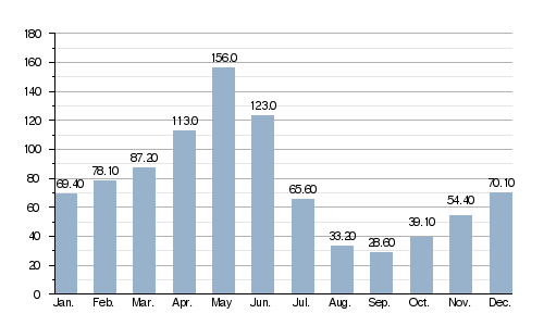
Average monthly discharge (cubic meters per second) at Pinsaguel
This graph shows how the amount of water in the Ariège river changes throughout the year. You can see that May usually has the most water flowing, while September and August have the least. This is because of things like snowmelt in spring and less rain in summer.
Where the River Flows
The Ariège river begins high up in the Pyrenees mountains. Its source is in a lake called Lac de Font Nègre. This spot is right on the border between France and Andorra. It's near a place called Pas de la Casa in Andorra. The source is very high up, about 2,470 meters (8,100 feet) above sea level!
At first, the river flows north, marking the border between France and Andorra. Then, it turns towards the northeast.
The Ariège flows through a flat area called the Ariège plain. It then leaves the Ariège department and enters the Haute-Garonne department. Finally, it joins the Garonne river at a town called Portet-sur-Garonne. This is close to the big city of Toulouse.
The Ariège river passes through several important places:
- In Andorra, it flows through the Parish of Canillo, near Pas de la Casa.
- In France, it flows through the Occitanie region, including:
- The Pyrénées-Orientales department, through towns like Porta.
- The Ariège department, passing through towns like Ax-les-Thermes, Tarascon-sur-Ariège, Foix, and Pamiers.
- The Haute-Garonne department, through towns like Auterive and Pinsaguel.
The river flows through a total of 58 different towns or communes in France. It ends its journey by joining the Garonne river at Portet-sur-Garonne. This meeting point is about 140 meters (460 feet) above sea level.
Rivers That Join the Ariège
Many smaller rivers and streams flow into the Ariège. These are called tributaries. Here are some of the main ones:
Right Tributaries
These rivers join the Ariège from its right side:
- Oriège: This river is about 21 kilometers (13 miles) long. It starts on the northern side of the Carlit peak and joins the Ariège at Ax-les-Thermes.
- Lauze: This one is about 14 kilometers (9 miles) long.
- Hers-Vif or Hers: This is the most important tributary, stretching about 130 kilometers (81 miles). It joins the Ariège at Cintegabelle in the Haute-Garonne department.
- Aïse: This river is about 29 kilometers (18 miles) long.
Left Tributaries
These rivers join the Ariège from its left side:
- Aston: This river is about 23 kilometers (14 miles) long.
- Vicdessos: This one is about 36 kilometers (22 miles) long. It joins the Ariège at Tarascon-sur-Ariège.
- Courbière: About 15 kilometers (9 miles) long, it joins the Ariège before Tarascon-sur-Ariège.
- Arget: This river is about 23 kilometers (14 miles) long. It flows into the Ariège at the foot of the Foix castle.
- Lèze: This river is about 70 kilometers (43 miles) long.
Gallery
-
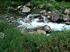
The Ariège near Ax-les-Thermes.
-
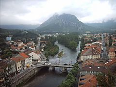
The Ariège river in Tarascon-sur-Ariège.
-
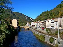
The Ariège in Foix.
-
The Ariège in Foix.
-
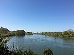
Confluence Ariège-Garonne.


.jpg)
See also
 In Spanish: Río Ariège para niños
