
Vézère facts for kids
The Vézère (which is Vesera in the Occitan language) is a river in southwestern France. It flows through two areas called departments: Corrèze and Dordogne, both in the Nouvelle-Aquitaine region. The Vézère is a river that flows into another, larger river called the Dordogne.
The valley around the Vézère river is very famous for its amazing prehistoric cave systems. These caves have many ancient cave paintings. Because these sites are so important, UNESCO named them a World Heritage Site in 1979. This means they are protected and recognized as special places for everyone in the world.
Quick facts for kids Vézère |
|
| River | |
 Bridge over the Vézère in Montignac.
|
|
| Country | France |
|---|---|
| Region | Nouvelle-Aquitaine |
| Departments | Corrèze, Dordogne |
| Communes | Brive-la-Gaillarde, Montignac |
| Tributaries | |
| - left | Brézou, Corrèze |
| - right | Bradascou, Loyre |
| Cities | Brive-la-Gaillarde, Montignac |
| Source | Meymac |
| - location | Corrèze, Nouvelle-Aquitaine, France |
| - elevation | 900 m (2,953 ft) |
| - coordinates | 45°35′2″N 0°53′28″E / 45.58389°N 0.89111°E |
| Confluence | Dordogne |
| - location | Limeuil, Nouvelle-Aquitaine, France |
| - elevation | 5 m (16 ft) |
| - coordinates | 44°52′53″N 0°53′28″E / 44.88139°N 0.89111°E |
| Length | 211.2 km (131 mi) |
| Basin | 3,736 km² (1,442 sq mi) |
| Discharge | for Campagne |
| - average | 57.7 m³/s (2,038 cu ft/s) |
Contents
About the Vézère River
The Vézère river is about 211.2 km (131.2 mi) long, which is roughly 131 miles. The area of land that drains into the Vézère, called its drainage basin, is about 3,736 km2 (1,442 sq mi) wide.
The amount of water flowing in the Vézère changes throughout the year. On average, about 57.7 m3/s (2,040 cu ft/s) of water flows past a point near Campagne every second. This is like a large swimming pool emptying very quickly! The river usually has the most water in February and the least in August.
Where the Vézère River Starts and Ends
The Vézère river begins high up in the Plateau de Millevaches, which is part of the Massif Central mountain range. It starts in a small town called Meymac in the Corrèze department, at a height of about 900 m (2,953 ft) (about 2,953 feet) above sea level.
From there, the river generally flows southwest. It travels through the Corrèze and Dordogne departments. Finally, the Vézère river joins the Dordogne river in a town called Limeuil. This meeting point is much lower, at about 5 m (16 ft) (about 16 feet) above sea level.
The Vézère river flows through one large region and two departments. It passes through 53 different towns and villages, called communes in France. Some of the main towns it flows through include:
- In the Nouvelle-Aquitaine region:
- In Corrèze: Chavanac, Pérols-sur-Vézère, Bugeat, Treignac, Uzerche, Vigeois, Larche
- In Dordogne: Terrasson-Lavilledieu, Montignac, Les Eyzies-de-Tayac-Sireuil, Le Bugue
Rivers that Join the Vézère
Many smaller rivers and streams flow into the Vézère. These are called tributaries. Here are some of the main ones that are longer than 20 kilometers (about 12 miles):
- Rivers joining from the left side:
- Ars - 20.7 km (about 12.9 miles)
- Brézou - 29.6 km (about 18.4 miles)
- Corrèze - 94.6 km (about 58.8 miles)
- Rivers joining from the right side:
- Soudaine - 25.8 km (about 16 miles)
- Bradascou - 33 km (about 20.5 miles)
- Loyre - 45.3 km (about 28.1 miles)
Images for kids
-
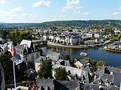
The Vézère river in Terrasson-Lavilledieu
-
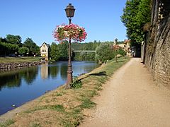
The Vézère river in Montignac.
-
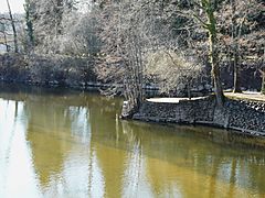
Confluence of the Dordogne, in front, and the Vézère.
.JPG)
.JPG)

More to Explore
See also
 In Spanish: Río Vézère para niños
