
Vézère Valley facts for kids
Quick facts for kids Vézère |
|
|---|---|
 |
|
| Country | France |
| Physical characteristics | |
| Main source | Plateau de Millevaches 970 m (3,180 ft) |
| River mouth | Dordogne 44°52′53″N 0°53′26″E / 44.88139°N 0.89056°E |
| Length | 211 km (131 mi) |
| Basin features | |
| Progression | Dordogne→ Gironde estuary→ Atlantic Ocean |
| Basin size | 3,708 km2 (1,432 sq mi) |

| UNESCO World Heritage Site | |
|---|---|

Vézère at La Madeleine site
|
|
| Includes |
|
| Criteria | Cultural: (i)(iii) |
| Inscription | 1979 (3rd Session) |
The Vézère Valley in France is famous for its amazing prehistoric caves. These caves hold many ancient cave paintings and hominid (early human) remains. You can find them along the Vézère river in the Dordogne area of the Nouvelle-Aquitaine region. The main towns nearby are Les Eyzies-de-Tayac-Sireuil and Montignac.
In 1979, UNESCO named these sites a World Heritage Site. This means they are very important to the world's history and culture. One of the most famous sites is the Lascaux cave.
Contents
Why the Vézère Valley is Special
The Vézère Valley is home to 147 prehistoric sites. It also has 25 caves with ancient art. These sites are important for understanding how early humans lived. They also show us how beautiful their art was.
The Lascaux Cave is especially famous. It was found in 1940. The cave paintings there are very important for the history of prehistoric art. They show about 100 animal figures, like horses and bulls. These paintings are amazing because of their detail, bright colors, and how lifelike they look.
Main Prehistoric Sites in the Valley
Here is a list of the most important sites in the Vézère Valley. These are the ones recognized by UNESCO. They are all found in different towns along the river.
| Code | Name | Coordinates | Town |
|---|---|---|---|
| 85-001 | Shelter of the Cro-Magnon | 44°56′25.6″N 1°00′34.6″E / 44.940444°N 1.009611°E | Les Eyzies-de-Tayac-Sireuil |
| 85-002 | Shelter of the Fish | 44°56′38.8″N 0°59′54.2″E / 44.944111°N 0.998389°E | |
| 85-003 | Font-de-Gaume Cave | 44°56′13.2″N 1°01′35.6″E / 44.937000°N 1.026556°E | |
| 85-004 | La Micoque | 44°57′27.6″N 1°00′23.5″E / 44.957667°N 1.006528°E | |
| 85-005 | La Mouthe Cave | 44°55′28.9″N 1°01′14.1″E / 44.924694°N 1.020583°E | |
| 85-006 | Laugerie-Basse | 44°57′03.8″N 0°59′57.5″E / 44.951056°N 0.999306°E | |
| 85-007 | Laugerie-Haute | 44°57′11.8″N 1°00′12.3″E / 44.953278°N 1.003417°E | |
| 85-008 | Le Grand Roc Cave | 44°56′58.2″N 0°59′54.0″E / 44.949500°N 0.998333°E | |
| 85-009 | Les Combarelles Cave | 44°56′36.8″N 1°02′31.6″E / 44.943556°N 1.042111°E | |
| 85-010 | Cap-Blanc Shelter | 44°56′44.3″N 1°05′50.6″E / 44.945639°N 1.097389°E | Marquay (on the Vézère) |
| 85-011 | Lascaux Cave | 45°03′13.3″N 1°10′12.0″E / 45.053694°N 1.170000°E | Montignac (on the Vézère) |
| 85-012 | Rouffignac Cave or Cro-de-Granville or Miremont Cave |
45°00′31.7″N 0°59′15.5″E / 45.008806°N 0.987639°E | Rouffignac-Saint-Cernin-de-Reilhac |
| 85-013 | Roc de Saint-Cirq Cave | 44°55′33.9″N 0°58′02.9″E / 44.926083°N 0.967472°E | Saint-Cirq |
| 85-014 | Le Moustier (2 shelters) | 44°59′39.6″N 1°03′35.5″E / 44.994333°N 1.059861°E | Saint-Léon-sur-Vézère and Peyzac-le-Moustier |
| 85-015 | La Madeleine Shelter | 44°58′01.3″N 1°02′11.1″E / 44.967028°N 1.036417°E | Tursac |
Images for kids
-
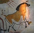
Lascaux, a replica in the Brno museum Anthropos.
-
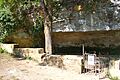
Entrance of the Roc de Saint-Cirq cave.
-
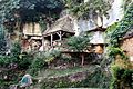
Shelter of the Cro-Magnon.
-
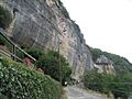
Le Grand Roc Cave


.jpg)
Related pages
See also
 In Spanish: Río Vézère para niños
