
Aquitaine facts for kids
Quick facts for kids Aquitaine |
|||
| Region | |||
|
|||
| Country | |||
|---|---|---|---|
| Préfecture | Bordeaux | ||
| - coordinates | 44°50′19″N 0°34′42″W / 44.83861°N 0.57833°W | ||
| Area | 41,284 km² (15,940 sq mi) | ||
| Population | 3,285,970 (2012) | ||
| Density | 80 /km² (207 /sq mi) | ||
| Subdivisions | 5 departments 18 arrondissements 235 cantons 2,296 communes |
||
| President | Alain Rousset | ||
| Timezone | CET (UTC+1) | ||
| - summer (DST) | CEST (UTC+2) | ||


Aquitaine (which is Aquitània in Occitan) is a region in southwestern France. It used to be its own administrative region. Now, it is part of a larger region called Nouvelle-Aquitaine.
Aquitaine is quite big, covering over 41,000 square kilometers. This makes it one of the largest regions in mainland France. The biggest French region overall is French Guiana, which is in South America.
The main city and capital of Aquitaine was Bordeaux. People from this region are called Aquitain in French.
The region was made up of five departments: Dordogne, Gironde, Landes, Lot-et-Garonne, and Pyrénées-Atlantiques.
Contents
Exploring Aquitaine's Geography
Aquitaine was the third largest region in Metropolitan France. It covered an area of about 41,284 square kilometers (15,940 square miles).
Where is Aquitaine Located?
Aquitaine shared borders with three other French regions:
- To the north: Poitou-Charentes
- To the northeast: Limousin
- To the east: Midi-Pyrénées
To the south, Aquitaine bordered Spain, specifically the regions of Aragon and Navarre. To the west, it met the Atlantic Ocean. The coastline along the Atlantic is known as the Côte d'Argent (Silver Coast).
 |
Poitou-Charentes | Limousin | |
|
| Atlantic Ocean | Midi-Pyrénées | |||
| Spain (Aragon and Navarre) |
The Greenwich Meridian, which is the imaginary line marking 0 degrees longitude, passes through Aquitaine.
Mountains and Rivers
Most of Aquitaine is a fairly flat area called the Aquitanian basin. It has a young geological landscape. High mountains are only found in the southern part of Aquitaine. These are part of the Pyrenees mountain range.
The highest point in Aquitaine is Pic Palas. It stands at 2,974 meters (9,757 feet) tall and is located on the border with Spain.
Several important rivers flow through the region:
- The Garonne flows through the Gironde and Lot-et-Garonne departments.
- The Dordogne flows through the Dordogne and Gironde departments.
- The Lot flows through the Lot-et-Garonne department.
- The Dropt flows through the Dordogne, Gironde, and Lot-et-Garonne departments.
- The Adour flows through the Landes department.
Aquitaine's Climate
The climate in Aquitaine is generally mild throughout the year, except in the high mountains. Along the Atlantic coast, the average yearly temperature is above 15°C (59°F). In Bordeaux, it's about 14°C (57°F). Even near the border of Limousin, it's still around 11°C (52°F). The region also gets a good amount of rain, especially more in the south.
A Look at Aquitaine's History
In the Middle Ages, Aquitaine was sometimes a kingdom and sometimes a duchy. Its size changed often due to various wars.
Aquitaine came under the control of England in 1152. This happened when Eleanor of Aquitaine married Henry II of England. It remained under English control until 1453. This was at the very end of the Hundred Years' War.
Departments of Aquitaine
The Aquitaine region was made up of five departments:
| Département | Main City | Population (2012) |
Area (km²) |
|---|---|---|---|
| Dordogne | Périgueux | 416,384 | 9,060 |
| Gironde | Bordeaux | 1,483,712 | 9,975 |
| Landes | Mont-de-Marsan | 392,884 | 9,243 |
| Lot-et-Garonne | Agen | 332,119 | 5,361 |
| Pyrénées-Atlantiques | Pau | 660,871 | 7,645 |
People of Aquitaine
In 2012, the Aquitaine region had a population of 3,285,970 people. This means there were about 80 people living in each square kilometer.

Here are the 10 largest cities in the region:
| City | Population (2012) |
Department |
|---|---|---|
| Bordeaux | 241,287 | Gironde |
| Pau | 78,506 | Pyrénées-Atlantiques |
| Mérignac | 66,660 | Gironde |
| Pessac | 59,223 | Gironde |
| Bayonne | 45,855 | Pyrénées-Atlantiques |
| Talence | 41,358 | Gironde |
| Anglet | 39,223 | Pyrénées-Atlantiques |
| Agen | 33,730 | Lot-et-Garonne |
| Mont-de-Marsan | 31,018 | Landes |
| Périgueux | 29,906 | Dordogne |
Gallery


.JPG)

Images for kids
-
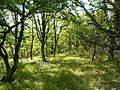
Landscape in Dordogne, Aquitaine
-
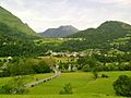
Landscape in Pyrénées-Atlantiques, Aquitaine
-
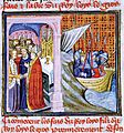
14th-century representation of the wedding of Eleanor of Aquitaine to Louis of France
-
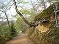
The footpath west from the Château de Pau
-
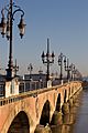
Bordeaux, Pont-de-Pierre
.JPG)


See also
 In Spanish: Aquitania para niños
