
Midi-Pyrénées facts for kids
Quick facts for kids Midi-Pyrénées |
|||
| Region | |||
|
|||
| Country | |||
|---|---|---|---|
| Préfecture | Toulouse | ||
| - coordinates | 43°36′16″N 1°26′38″E / 43.60444°N 1.44389°E | ||
| Area | 45,348 km² (17,509 sq mi) | ||
| Population | 2,926,592 (2012) | ||
| Density | 65 /km² (168 /sq mi) | ||
| Subdivisions | 8 departments 22 arrondissements 293 cantons 3,020 communes |
||
| President | Martin Malvy | ||
| Timezone | CET (UTC+1) | ||
| - summer (DST) | CEST (UTC+2) | ||


Midi-Pyrénées was a former administrative region in France. It is now part of a larger region called Occitanie. It was also part of a historical area known as Occitania.
Its name, Midi-Pyrénées, comes from its geography. Midi means "southern France." Pyrénées refers to the Pyrenees mountains, which are the highest mountains in the region. People from this region are called Midi-Pyrénéen.
The region included eight departments: Ariège, Aveyron, Haute-Garonne, Gers, Lot, Hautes-Pyrénées, Tarn, and Tarn-et-Garonne. Its capital city was Toulouse.
Contents
Geography of Midi-Pyrénées
The Midi-Pyrénées region was the largest region in Metropolitan France. It covered an area of 45,348 square kilometers (17,509 sq mi). To the south, it shared borders with Spain and Andorra.
It also bordered four other French regions: Aquitaine to the west, Limousin to the north, Auvergne to the northeast, and Languedoc-Roussillon to the east.
Landscapes and Rivers
The region had three main types of landscapes:
- The southern part has the high Pyrenees mountains.
- The northeast and north are part of the Massif Central highlands.
- The central and northwestern areas are flat. This flat zone is shaped by the Garonne river and its smaller rivers. These rivers drain most of the region into the Atlantic Ocean.
The highest point in Midi-Pyrénées was the Pic Vignemale. It stands at 3,299 meters (10,823 ft) tall and is located on the border with Spain. The Vignemale is part of the Pyrénées National Park.
The main rivers in the region are the Garonne river and the Adour river. The Garonne flows through the Haute-Garonne, Hautes-Pyrénées, and Tarn-et-Garonne departments. The Adour flows through the Hautes-Pyrénées and Gers departments.
Departments of the Region
The Midi-Pyrénées region was made up of eight departments. Each department has its own main city, called a préfecture.
| Département | Préfecture | Population (2012) |
Area (km²) |
Density (Inh./km²) |
|---|---|---|---|---|
| Ariège | Foix | 152,366 | 4,890 | 31.2 |
| Aveyron | Rodez | 276,229 | 8,735 | 31.6 |
| Haute-Garonne | Toulouse | 1,279,349 | 6,309 | 202.8 |
| Gers | Auch | 189,530 | 6,257 | 30.3 |
| Lot | Cahors | 174,346 | 5,217 | 33.4 |
| Hautes-Pyrénées | Tarbes | 228,854 | 4,464 | 51.3 |
| Tarn | Albi | 378,947 | 5,758 | 65.8 |
| Tarn-et-Garonne | Montauban | 246,971 | 3,718 | 66.4 |
Population and Cities
In 2012, the Midi-Pyrénées region had a population of 2,926,592 people. This means there were about 64.5 people living in each square kilometer.

Here are the 10 largest cities in the region by population in 2012:
| City | Population (2012) |
Départment |
|---|---|---|
| Toulouse | 453,317 | Haute-Garonne |
| Montauban | 56,887 | Tarn-et-Garonne |
| Albi | 49,231 | Tarn |
| Tarbes | 41,664 | Hautes-Pyrénées |
| Castres | 41,529 | Tarn |
| Colomiers | 36,699 | Haute-Garonne |
| Tournefeuille | 26,342 | Haute-Garonne |
| Muret | 24,492 | Haute-Garonne |
| Rodez | 23,744 | Aveyron |
| Blagnac | 22,983 | Haute-Garonne |
Gallery
-
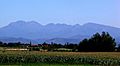
Massif of Tabe, Ariège
-
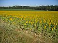
Sunflowers in Gers
-
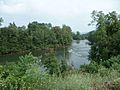
Salat river, Haute-Garonne
-
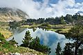
Middle Lake of Bastan, Hautes-Pyrénées
-
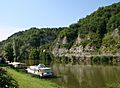
Lot river in Lot


Images for kids
-
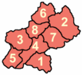
Departments: Ariège, Aveyron, Gers, Haute-Garonne, Hautes-Pyrénées, Lot, Tarn, Tarn-et-Garonne
-
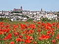
Albi
-
Rodez
-
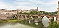
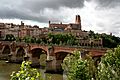
Albi Cathedral and Old Bridge


_North_views_of_the_Ste_C%C3%A9cile_Cathedral_and_the_Old_Bridge.jpg)
See also
 In Spanish: Mediodía-Pirineos para niños
