
Aurillac facts for kids
Quick facts for kids
Aurillac
|
||
|---|---|---|
|
Prefecture and commune
|
||

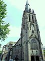
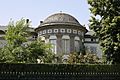
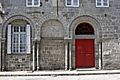
The church of Saint-Géraud and surrounding buildings, in Aurillac
|
||
|
||

Aurillac
Location in France

Aurillac
Location in Auvergne-Rhône-Alpes
|
||
| Country | France | |
| Region | Auvergne-Rhône-Alpes | |
| Department | Cantal | |
| Arrondissement | Aurillac | |
| Canton | Aurillac-1, 2 and 3 | |
| Intercommunality | CA Bassin d'Aurillac | |
| Area
1
|
28.76 km2 (11.10 sq mi) | |
| Population
(2010)
|
27,924 | |
| • Density | 970.93/km2 (2,514.7/sq mi) | |
| Demonym(s) | Aurillacois | |
| Time zone | UTC+01:00 (CET) | |
| • Summer (DST) | UTC+02:00 (CEST) | |
| INSEE/Postal code |
15014 /15000
|
|
| Elevation | 573–867 m (1,880–2,844 ft) (avg. 622 m or 2,041 ft) |
|
| Website | www.ville-aurillac.fr | |
| 1 French Land Register data, which excludes lakes, ponds, glaciers > 1 km2 (0.386 sq mi or 247 acres) and river estuaries. | ||
.svg)
Aurillac (pronounced "Oh-ree-yak") is a town in France. It's the main city, or prefecture, of the Cantal area, which is like a county. Aurillac is located in the Auvergne-Rhône-Alpes region of France.
This town was once part of an older French region called Auvergne.
Contents
History of Aurillac
The name Aurillac comes from an old Latin name, Aureliacum. This means "Roman villa of Aurelius." A villa was a large country house or estate in Roman times.
Geography of Aurillac
Aurillac is located at the bottom of the Mounts of Cantal, which are part of the Massif Central mountain range. The town is built along the Jordanne river. This river flows into the larger Cère river.
The town covers an area of about 28.8 square kilometers (11.1 square miles). Its average height above sea level is 622 meters (2,041 feet). At the town hall, the height is 620 meters (2,034 feet).
Aurillac is about 558 kilometers (347 miles) southeast of Paris. It is also about 223 kilometers (139 miles) south of Toulouse. The towns surrounding Aurillac include Crandelles, Naucelles, Saint-Simon, Giou-de-Mamou, Arpajon-sur-Cère, Roannes-Saint-Mary, Sansac-de-Marmiesse, and Ytrac.
What is the Climate Like in Aurillac?
Aurillac has an oceanic climate. This means it has cool winters and warm summers. Even though it's far from the ocean, its climate is still influenced by it.
The average temperature in Aurillac for the whole year is about 10.2°C (50.4°F).
- The warmest month is usually July, with an average temperature of 18.3°C (64.9°F).
- The coolest month is January, with an average temperature of 2.9°C (37.2°F).
Aurillac gets about 856 millimeters (33.7 inches) of rain each year.
- December is usually the wettest month, with about 109.2 millimeters (4.3 inches) of rain.
- June is typically the driest month, with about 45.7 millimeters (1.8 inches) of rain.
| Climate data for Aurillac, France | |||||||||||||
|---|---|---|---|---|---|---|---|---|---|---|---|---|---|
| Month | Jan | Feb | Mar | Apr | May | Jun | Jul | Aug | Sep | Oct | Nov | Dec | Year |
| Mean daily maximum °C (°F) | 6.6 (43.9) |
7.9 (46.2) |
11.2 (52.2) |
13.7 (56.7) |
17.8 (64.0) |
21.5 (70.7) |
24.3 (75.7) |
24.0 (75.2) |
20.3 (68.5) |
16.0 (60.8) |
10.4 (50.7) |
7.5 (45.5) |
15.1 (59.2) |
| Daily mean °C (°F) | 2.9 (37.2) |
3.6 (38.5) |
6.3 (43.3) |
8.6 (47.5) |
12.6 (54.7) |
15.8 (60.4) |
18.3 (64.9) |
18.0 (64.4) |
14.6 (58.3) |
11.4 (52.5) |
6.4 (43.5) |
3.7 (38.7) |
10.2 (50.3) |
| Mean daily minimum °C (°F) | −1.0 (30.2) |
−0.8 (30.6) |
1.3 (34.3) |
3.4 (38.1) |
7.3 (45.1) |
10.1 (50.2) |
12.2 (54.0) |
11.9 (53.4) |
8.9 (48.0) |
6.7 (44.1) |
2.3 (36.1) |
−02 (28) |
5.0 (41.0) |
| Average rainfall mm (inches) | 93.3 (3.67) |
76.3 (3.00) |
65.5 (2.58) |
64.9 (2.56) |
61.3 (2.41) |
45.5 (1.79) |
47.4 (1.87) |
49.5 (1.95) |
55.4 (2.18) |
91.5 (3.60) |
95.8 (3.77) |
109.8 (4.32) |
856.2 (33.7) |
| Source: Weatherbase.com [1] | |||||||||||||
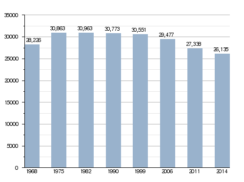
Population of Aurillac
People who live in Aurillac are called Aurillacois (for men) or Aurillacoises (for women) in French.
In 2014, the town of Aurillac had a population of 26,135 people. This means there were about 909 people living in each square kilometer of the town.
Evolution of the population in Aurillac
How Aurillac is Governed
Aurillac is the main city, or prefecture, of the Cantal department. It is also the capital of the Aurillac area. An arrondissement is a type of administrative division in France.
Aurillac is also the main town for three different cantons:
- Aurillac-1: This canton includes 2 towns and had 10,296 people in 2014.
- Aurillac-2: This canton includes 1 town and had 9,591 people in 2014.
- Aurillac-3: This canton includes 1 town and had 10,369 people in 2014.
Aurillac is part of a group of towns called Bassin d'Aurillac. This group works together on things like public transport and waste management.
Sister Cities of Aurillac
Aurillac has "sister city" relationships with several towns around the world. This means they share cultural and educational exchanges. Aurillac and Arpajon-sur-Cère are twinned with:
 Bocholt (Germany) since 1972.
 Bassetlaw (United Kingdom) since 1980.
 Bougouni (Mali) since 1985.
 Altea (Spain) since 1992.
 Vorona (Romania) since 2000.
Places to Visit in Aurillac
Aurillac has several interesting historical sites:
- Saint-Géraud d'Aurillac Abbey: This old abbey dates back to the 11th century.
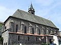
- Notre-Dame-aux-Neiges church: This church was built in 1332.
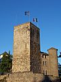
- Chateau of Saint-Etienne: A castle from the 9th century.
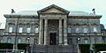
- Aurillac Town Hall: The town hall building was built in the 17th century.
Gallery

-
Chateau de Saint-Etienne
-

Aurillac City Hall
-
Saint-Géraud church
-
Notre-Dame-aux-Neiges church


Related pages
Images for kids
-
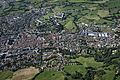
Aerial view of Aurillac
-
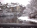
Houses along the Jordanne
-
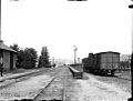
The Station at Aurillac in 1898
-

Boutique Gentiane Couderc
-

Bleu d'Auvergne
-

Concert at Le Prisme
-
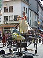
Festival of Street theatre at Aurillac
-
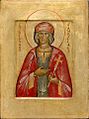
Saint Gerald of Aurillac
-
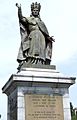
Statue of Pope Sylvester II (1851)
-

L-F Grognier
-
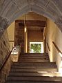
Stairs in the Présidial
-
Remains of the Abbey hospital of Saint-Géraud -
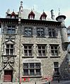
The Consul's House -
The Palace of Justice -
The Police Station
-
The Prison
-
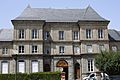
The Prefecture
-
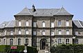
The Hotel Meynard
-
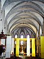
Nave of the Church of Notre-Dame-aux-Neiges
-
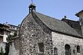
Chapel of Aurinques
-
Old Abbey Hospital
-
Old Abbey Hospital


.jpg)


.JPG)


See also
 In Spanish: Aurillac para niños
