
Plomb du Cantal facts for kids
Quick facts for kids Plomb du Cantal |
|
|---|---|

Plomb du Cantal viewed from Saint-Jacques-des-Blats
|
|
| Highest point | |
| Elevation | 1,855 m (6,086 ft) |
| Prominence | 774 m (2,539 ft) |
| Parent peak | Mounts of Cantal |
| Geography | |
|
Lua error in Module:Location_map at line 420: attempt to index field 'wikibase' (a nil value).
|
|
| Location | Cantal, France |
| State/Province | FR |
| Parent range | Massif Central |
| Geology | |
| Mountain type | Stratovolcano |
| Climbing | |
| Easiest route | Hiking from Super Lioran, a ski resort |
The Plomb du Cantal is a tall mountain in France. It is the highest point of the Mounts of Cantal range. This mountain is part of the Massif Central in central France. It is also located within the Regional Natural Park of the Volcanoes of Auvergne (which in French is called Parc Naturel Régional des Volcans d'Auvergne).
The Plomb du Cantal is the highest mountain in the Cantal area. It is the second highest mountain in the entire Massif Central. Only Puy de Sancy, which is 1,885 meters (6,184 feet) high, is taller.
Contents
Where is Plomb du Cantal?
Plomb du Cantal is found in the Mounts of Cantal. This is a chain of volcanic mountains. They are located in the middle of the Cantal department. The mountain is about 40 kilometers (25 miles) northeast of Aurillac. Aurillac is the main city of the Cantal department.
The very top of the mountain sits on the edge of two local areas. These areas are called communes. They are Saint-Jacques-des-Blats to the west and Albepierre-Bredons to the east.
Rivers and Water Flow
Many rivers begin on the sides of Plomb du Cantal. These rivers flow into three main drainage basins. A drainage basin is an area of land where all the water flows to a single river or lake.
- To the west, near Saint-Jacques-des-Blats, water flows into the Cère river. This river then joins the Dordogne river.
- To the south, near the area of Brezons, water flows into the Brezons river. This river eventually reaches the Garonne river.
- To the northeast, near Albepierre-Bredons, water flows into the Alagnon river. This river flows into the Loire river.
The Giant Volcano
The Plomb du Cantal, along with other nearby mountains, is part of a huge stratovolcano. This is the largest stratovolcano in France. It is also one of the biggest in Europe. This ancient volcano covers an area of almost 2,500 square kilometers (970 square miles). About 4 million years ago, this volcano was much taller. It may have reached 3,000 meters (9,800 feet) or even higher!
Important Bird Area
The Plomb du Cantal and the Mounts of Cantal are very important for migratory birds. These are birds that travel long distances each year. Because of this, the area has been a Special Protection Area since 2005. This means it is a protected place for birds. Its official name is FR8310066 - Monts et Plomb du Cantal.
Fun Activities: Skiing and Climbing
Plomb du Cantal is a popular spot for outdoor activities.
Ski Resorts
There are two main ski resorts on or near the slopes of Plomb du Cantal. These are places where people go to ski. They are called Le Lioran (also known as Super Lioran) and Prat-de-Bouc.
How to Reach the Top
There are a few ways to get to the top of Plomb du Cantal:
- You can take a cable car up to the Lioran station. From there, it's a short 10-minute hike to the summit.
- You can hike all the way from the Lioran station. This takes about 1 hour and a half.
- You can hike from the Prat-de-Bouc parking lot. This longer hike takes about 2 hours.
Images for kids
-
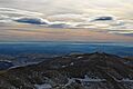
The Plomb du Cantal.
-
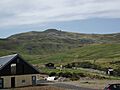
The Col de Prat-de-Bouc and the Plomb du Cantal.
-
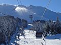
Plomb du Cantal cable car in Lioran


See also
 In Spanish: Plomb du Cantal for kids
