
Alagnon facts for kids
Quick facts for kids Alagnon |
|
| River | |
 Confluence of Alagnon and Alagnonnette
|
|
| Country | |
|---|---|
| Region | Auvergne-Rhône-Alpes |
| Departments | Cantal, Haute-Loire, Puy-de-Dôme |
| Tributaries | |
| - left | Allanche, Sianne, Bave, Auze |
| - right | Arcueil, Alagnonnette, Violette |
| Source | Mounts of Cantal |
| - location | Laveissière, Cantal, France |
| - elevation | 1,590 m (5,217 ft) |
| - coordinates | 45°5′58″N 2°43′17″E / 45.09944°N 2.72139°E |
| Confluence | Allier |
| - location | Auzat-la-Combelle, Puy-de-Dôme, France |
| - elevation | 390 m (1,280 ft) |
| - coordinates | 45°27′8″N 3°18′14″E / 45.45222°N 3.30389°E |
| Length | 85.9 km (53 mi) |
| Basin | 1,042 km² (402 sq mi) |
| Discharge | for Lempdes-sur-Allagnon |
| - average | 11.9 m³/s (420 cu ft/s) |
The Alagnon is a river in France. It begins in the Massif Central mountains, inside a special nature park called the Regional Natural Park of the Volcanoes of Auvergne (French: Parc Naturel Régional des Volcans d'Auvergne). The river flows through the Auvergne-Rhône-Alpes region. It is a branch, or "tributary," that flows into the Allier River from the left side.
Contents
The Alagnon River's Journey
The Alagnon river is about 85.9 km (53.4 mi) long. The area of land that drains water into the Alagnon is called its drainage basin. This basin covers about 1,042 km2 (402 sq mi).
The river's average yearly discharge is 11.90 m3/s (420 cu ft/s). Discharge means the amount of water that flows past a certain point in the river each second. This measurement is taken near Lempdes-sur-Allagnon in the Haute-Loire department.
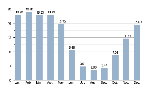
Average monthly water flow (in cubic meters per second) at Lempdes-sur-Allagnon (over 50 years)
Where the Alagnon River Flows
The Alagnon river starts high up in the Mounts of Cantal. These mountains are part of the Massif Central. It begins near a mountain called Puy Bataillouse, in a town called Laveissière. The starting point is very high, about 1,590 m (5,217 ft) above sea level.
At first, the river flows towards the east. It passes near the Super Lioran ski resort. Then, it enters a narrow, deep gorge and later a valley near Murat. The river generally flows towards the northeast. It goes through even deeper gorges when it reaches Lempdes-sur-Allagnon.
The Alagnon river flows through the Auvergne-Rhône-Alpes region of France. It passes through three different departments and 23 communes (which are like small towns or districts). Two of these communes are even named after the river: La Chapelle-d'Alagnon and Lempdes-sur-Allagnon.
Here are some of the places the river flows through:
- In the Auvergne-Rhône-Alpes region:
- In the Cantal department: Laveissière, Murat, La Chapelle-d'Alagnon, Neussargues-Moissac, Ferrières-Saint-Mary, Molompize, Massiac
- In the Haute-Loire department: Grenier-Montgon, Torsiac, Lempdes-sur-Allagnon
- In the Puy-de-Dôme department: Charbonnier-les-Mines, Beaulieu, Auzat-la-Combelle
Finally, the Alagnon river joins the Allier River. This happens in the town of Auzat-la-Combelle, in a spot known as Le Saut du Loup, located in the Puy-de-Dôme department.
Main Tributaries
A tributary is a smaller stream or river that flows into a larger one. Here are the main tributaries of the Alagnon river that are longer than 20 kilometers:
|
Rivers joining from the left:
|
Rivers joining from the right:
|
Gallery
-
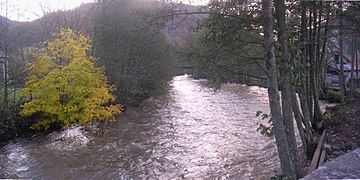
The Alagnon in Torsiac.
-
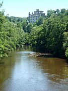
The Alagnon and the Léotoing castle.
-
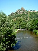
The Alagnon in Molompize.


See Also
