
Yonne (river) facts for kids
Quick facts for kids Yonne |
|
| River | |
 The Yonne river at Auxerre
|
|
| Country | France |
|---|---|
| Regions | Bourgogne-Franche-Comté, Île-de-France |
| Departments | Nièvre, Yonne, Seine-et-Marne |
| Communes | Corbigny, Clamecy, Auxerre, Migennes, Joigny, Villeneuve-sur-Yonne, Sens, Montereau-Fault-Yonne |
| Tributaries | |
| - left | Beuvron |
| - right | Cure, Serein, Armançon, Vanne |
| Cities | Auxerre, Sens |
| Source | Morvan |
| - location | Glux-en-Glenne, Nièvre, France |
| - elevation | 738 m (2,421 ft) |
| - coordinates | 46°57′22″N 4°0′39″E / 46.95611°N 4.01083°E |
| Mouth | Seine |
| - location | Montereau-Fault-Yonne, Seine-et-Marne, France |
| - elevation | 47 m (154 ft) |
| - coordinates | 48°23′19″N 2°57′26″E / 48.38861°N 2.95722°E |
| Length | 292.3 km (182 mi) |
| Basin | 10,836 km² (4,184 sq mi) |
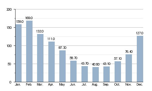
| Discharge | for Courlon-sur-Yonne |
| - average | 91.7 m³/s (3,238 cu ft/s) |
The Yonne River is an important river located in the northern part of France. It flows mostly through the western area of the Bourgogne-Franche-Comté region. The river is so significant that it gave its name to the Yonne department and to many towns, called communes, along its path. The Yonne is the main river that joins the Seine river from its left side.
During the time of the Roman Empire, the river was known as Icauna. This Latin name probably came from an older Celtic name for the river.
Contents
Exploring the Yonne River
The Yonne river is about 292.3 km (181.6 mi) long. The area of land that drains into the river, called its drainage basin, covers a huge 10,836 km2 (4,184 sq mi) area.
The average amount of water flowing through the river each year is 91.70 cubic metres per second. This measurement is taken at a place called Courlon-sur-Yonne.
 |
|
|
Where the Yonne River Starts and Ends
The source of the Yonne river is on the Prénely mountain. This mountain is located in the southern part of the Morvan hills. The exact spot is in the Glux-en-Glenne commune (town) in the Nièvre department. It starts at a high point, about 738 m (2,421 ft) above sea level.
.jpg)
The Yonne river generally flows from the southeast towards the northwest. It passes through 115 different communes (towns). Most of these towns are in the Bourgogne-Franche-Comté region. Some of the main towns it flows through include:
- In Nièvre (department number 58): Corbigny and Clamecy.
- In Yonne (department number 89): Auxerre, Joigny, Sens, Pont-sur-Yonne, and Villeneuve-sur-Yonne.
- In Seine-et-Marne (department number 77): Montereau-Fault-Yonne.
Finally, the Yonne river joins the Seine river in the town of Montereau-Fault-Yonne. It joins the Seine as a left tributary, meaning it flows into the Seine from the left side if you are looking downstream. This meeting point is about 47 m (154 ft) above sea level.
Main Rivers Joining the Yonne
Several smaller rivers, called tributaries, flow into the Yonne river. Here are some of the most important ones:
- Left tributary:
- Beuvron - This river is 40.5 km long.
- Right tributaries:
Gallery
-
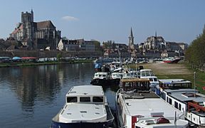
View of Auxerre and the Yonne
-
Sens on the Yonne river
-
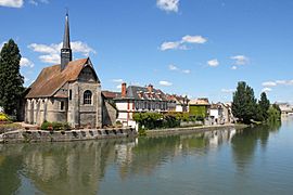
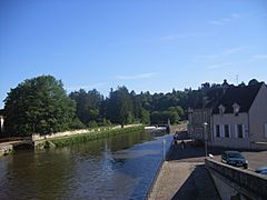
Saint-Aubin-sur-Yonne and a bridge on the Yonne river
-
Clamecy and the Yonne river
-
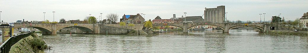
Confluence at Montereau-Fault-Yonne, the Seine to the left and the Yonne to the right.

.jpg)


Related pages
See also
 In Spanish: Río Yonne para niños
