
Saarland facts for kids
Quick facts for kids
The Saar
Saarland
|
|||
|---|---|---|---|
|
|||

Position of the Saarland in Germany
|
|||
| Country | Germany | ||
| Capital | Saarbrücken | ||
| Area | |||
| • Total | 2,569 km2 (992 sq mi) | ||
| Population
(2011)
|
|||
| • Total | 1,014,000 | ||
| • Density | 394.71/km2 (1,022.3/sq mi) | ||
| Time zone | UTC+1 (CET) | ||
| • Summer (DST) | UTC+2 (CEST) | ||
| Website | saarland.de | ||


Saarland is a small state, also called a Bundesland, in Germany. It covers about 2,568 square kilometers (992 square miles). In 2011, about 1,014,000 people lived there. Saarland is in the southwest part of Germany. It is close to the French border, near the city of Metz. The main city and capital of Saarland is Saarbrücken.
Contents
History of Saarland
How Saarland Became a State
In 1920, after World War I, the Treaty of Versailles created Saarland. It was made from parts of two areas: the Prussian Rhine Province and the Rhine Palatinate. These areas were put under the control of the League of Nations for 15 years. The League of Nations was an organization that worked for world peace.
Returning to Germany
After 15 years, in 1935, people in Saarland had a special vote called a plebiscite. They voted to join Germany again. So, Saarland became part of Germany once more.
After World War II
After World War II, Saarland came under the control of France. In 1947, Saarland was allowed to have its own government for most things. However, it was not fully independent. Finally, in 1957, Germany got Saarland back. It then became one of Germany's official states, or Bundesländer.
Geography of Saarland
Saarland is located in a special spot. To the south, it shares a border with France. To the northwest, it borders Luxembourg. To the north and east, it is next to another German state called Rhineland-Palatinate.
Districts of Saarland
Saarland is divided into 6 smaller areas called districts. These districts help manage the state.
- Merzig-Wadern (This is the largest district in Saarland.)
- Neunkirchen
- Saarbrücken
- Saarlouis
- Saarpfalz (This district is also known as Saar-Palatinate.)
- Sankt Wendel
Major Cities and Towns
Saarland has several important cities and towns. These are places where many people live and work.
- Saarbrücken (This is the capital city.)
- Neunkirchen
- Saarlouis
- Homburg
- Merzig
Related Pages
Images for kids
-
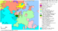
Map of the Saar Region in 1793

See also
 In Spanish: Sarre para niños
