
Sankt Wendel District facts for kids
Quick facts for kids
Sankt Wendel
|
|
|---|---|
 |
|
| Country | |
| State | Saarland |
| Capital | Sankt Wendel |
| Area | |
| • Total | 476.09 km2 (183.82 sq mi) |
| Population
(2002)
|
|
| • Total | 95,119 |
| • Density | 199.7921/km2 (517.459/sq mi) |
| Time zone | UTC+1 (CET) |
| • Summer (DST) | UTC+2 (CEST) |
| Vehicle registration | WND |
| Website | landkreis-st-wendel.de |
Sankt Wendel is a special area in the north of the Saarland, Germany. It's called a "district" or Kreis in German. It shares borders with other districts like Trier-Saarburg, Birkenfeld, Kusel, Neunkirchen, Saarlouis, and Merzig-Wadern.
Contents
A Look Back: History of Sankt Wendel
How the District Was Formed
The Sankt Wendel district was created a long time ago in 1834. This happened when a powerful kingdom called Prussia bought a piece of land known as Lichtenfeld. They bought it from another smaller state called Saxe-Coburg and Gotha.
Changes After World War I
After World War I, which was a very big global conflict, the Saar area (where Sankt Wendel is) was put under special management by the League of Nations. This was an organization that tried to keep peace in the world. Because of this, the Sankt Wendel district was split into two parts. The northern part was called the Restkreis Sankt Wendel. It was joined with the Birkenfeld district. The southern part stayed in the Saarland, but it was much smaller than before.
Exploring the Land: Geography
Hills and Rivers
The Sankt Wendel district is located in a natural area called the Saar-Hunsrück. This is a hilly region where the land goes up and down. The hills are usually between 200 and 600 meters high.
The main river that flows through the district is the Nahe. It's an important waterway for the area.
The Bostalsee Lake
One of the most interesting places in the district is the Bostalsee. This is the biggest tourist lake in the southwest of Germany. It covers a large area, about 1.2 square kilometers. It's a popular spot for visitors and locals to enjoy nature and water activities.
Towns and Communities
The Sankt Wendel district is made up of several towns and smaller communities. Here are some of them:
Main Town
- Sankt Wendel
Other Communities
Images for kids
-
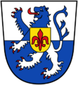
The coat of arms for the Sankt Wendel district. The blue lion is from the counts of Veldenz, and the silver lion is from Nassau-Saarbrücken. The flower in the middle is a fleur-de-lis, from the city of Sankt Wendel, with colors from Lorraine.

