Merzig-Wadern District facts for kids
Quick facts for kids
Merzig-Wadern
|
|
|---|---|
 |
|
| Country | |
| State | Saarland |
| Capital | Merzig |
| Area | |
| • Total | 555.00 km2 (214.29 sq mi) |
| Population
(2001)
|
|
| • Total | 106,088 |
| • Density | 191.1495/km2 (495.075/sq mi) |
| Time zone | UTC+1 (CET) |
| • Summer (DST) | UTC+2 (CEST) |
| Vehicle registration | MZG |
| Website | landkreis-merzig-wadern.de |
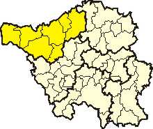
Merzig-Wadern is a special area called a 'district' (or Kreis in German). It is located in the northeast part of Saarland, a state in Germany. It's a place where many people live and work, and it has its own local government.
History
The Merzig-Wadern district was formed a long time ago, in 1816. Back then, this area became part of Prussia, a powerful German kingdom.
After World War I, the Saar region was managed by the League of Nations. This group was like an early version of the United Nations. They split the district into two parts. The area around Wadern stayed with Prussia. But the Merzig area became part of the special "Saar territory" (called Saargebiet).
In 1935, the Saar territory rejoined Germany. However, the two parts of the Merzig-Wadern district were not reunited right away. They finally came back together in 1946, after World War II.
Geography
The Saar River flows right through the Merzig-Wadern district. This river is an important waterway in the region.
The Moselle River forms the western border of the district. This river also creates a natural boundary with the country of Luxembourg.
Coat of Arms
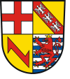
The coat of arms is like a special symbol or emblem for the Merzig-Wadern district. It shows important symbols from different groups that once owned land in this area.
 |
|
Towns and Municipalities
The Merzig-Wadern district is made up of several towns and smaller communities called municipalities. Here are the main ones:
| Towns | Municipalities |
|---|---|
|
|
 | Sharif Bey |
 | Hale Woodruff |
 | Richmond Barthé |
 | Purvis Young |

