
Saar River facts for kids
Quick facts for kids Saar - Sarre |
|
| River | |
 Saar loop at Mettlach
|
|
| Countries | France, Germany |
|---|---|
| Départments | Moselle, Bas-Rhin |
| Bundesländer | Saarland, Rhineland-Palatinate |
| Tributaries | |
| - left | Nied |
| - right | Blies, Prims |
| Primary source | Sarre Blanche |
| - location | Vosges Mountains, Grand Est, France |
| Secondary source | Sarre Rouge |
| Mouth | Moselle River |
| - coordinates | 49°42′5″N 6°34′11″E / 49.70139°N 6.56972°E |
| Length | 246 km (153 mi) |
| Basin | 7,431 km² (2,869 sq mi) |
| Discharge | for the confluence with the Moselle River |
| - average | 75 m³/s (2,649 cu ft/s) |
The Saar (in French: Sarre) is a river that flows through northeastern France and western Germany. It is a major branch, or tributary, of the Moselle River. The Saar begins in the Vosges Mountains in France and flows northwards. It eventually joins the Moselle River near the city of Trier in Germany.
The first time the Saar River was written about was in a Latin poem called Mosella. This poem was written by a Roman poet named Decimus Magnus Ausonius. He called the river Saravus.
Contents
Saar River Facts


The Saar River is the longest tributary of the Moselle River. It is about 246 kilometers (153 miles) long. The area of land that drains into the Saar River, called its drainage basin, is about 7,431 square kilometers (2,869 square miles).
Where the Saar River Flows
The Saar River starts at the bottom of Mont Donon. This is the highest peak in the northern part of the Vosges Mountains.
The river first flows for about 126 kilometers (78 miles) through the French region of Grand Est. For about 11 kilometers (7 miles), the Saar River forms the border between France and Germany. This happens after it joins with the Blies river, between the towns of Sarreguemines and Saarbrücken. After this, the river enters Germany.
The Saar then flows for about 68 kilometers (42 miles) through the German state of Saarland. It then travels about 31 kilometers (19 miles) through Rhineland-Palatinate. Finally, it flows into the Moselle River at Konz. This spot is between Trier and the border with Luxembourg.
The Start of the Saar: Red and White Saars
The Saar River actually begins from two smaller rivers. These are called the Sarre Rouge (Red Saar) and Sarre Blanche (White Saar).
Both the Red and White Saar rivers start on Mont Donon. Their starting points are less than 1 kilometer (0.6 miles) apart. The White Saar begins near Grandfontaine in the Bas-Rhin department. The Red Saar starts near Abreschviller in the Moselle department. These two rivers meet near Hermelange, south of Sarrebourg.

Here are some facts about the two rivers that form the Saar:
| River | Water Flow (average) | Length | Drainage Area | Starting Height | Coordinates |
|---|---|---|---|---|---|
| Red Saar | 1.86 cubic meters per second | 26.8 km (16.7 mi) | 107.3 km² (41.4 sq mi) | 785 meters (2,575 ft) | 48°32′4.3″N 07°2.7′0″E / 48.534528°N 7.04500°E |
| White Saar | 1.60 cubic meters per second | 26.6 km (16.5 mi) | 80.4 km² (31.0 sq mi) | 710 meters (2,330 ft) | 48°31′37″N 07°09′45″E / 48.52694°N 7.16250°E |
The Saar River and its two starting rivers first flow through the Moselle department in France. Then, for a short distance, they go through the Bas-Rhin department. From Sarrealbe to Sarreguemines, the Saar flows along the border with Germany. At Sarreguemines, the Blies river joins the Saar. The Blies is the largest river that flows into the Saar.
The Middle and Lower Saar
From Sarreguemines, the Saar River becomes navigable. This means it is deep, wide, and calm enough for ships to travel on it. The Saar then enters Germany. It flows through a narrow valley in the western Rhenish Massif mountains.
At the beginning of this part of its journey, the Saar forms a very famous bend. This is known as the Saar loop (in German: Saarschleife) near the town of Mettlach.
After flowing for 246 kilometers (153 miles), the Saar River joins the Moselle River. This happens at Konz in Rhineland-Palatinate, Germany. This area is known for growing Grapes. These grapes are used to make wine, especially between the towns of Serrig and Konz.
Rivers Joining the Saar

Many smaller rivers and streams flow into the Saar River. These are called tributaries. Here are some of the important ones:
|
Rivers joining from the left:
|
Rivers joining from the right
|
Cities and Towns Along the Saar
Many towns and cities are located along the banks of the Saar River. Here are some of them:
| Country | Region/State | Towns and Cities |
|---|---|---|
| France | Moselle (department) | Abreschviller (where the Sarre Rouge starts), Lorquin, Sarrebourg, Fénétrange |
| Bas-Rhin (department) | Sarre-Union | |
| Moselle (department) | Sarralbe, Sarreguemines | |
| Germany | Bundesländer | Towns and Cities |
| Saarland | Saarbrücken, Völklingen, Wadgassen, Bous, Saarlouis, Dillingen, Merzig | |
| Rhineland-Palatinate | Saarburg, Konz |
Related Pages
Images for kids
-
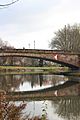
Bridge over the Saar at Saarbrücken
-
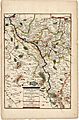
Course of the Saar (1703)
-
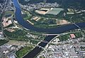
Confluence of Saar and Moselle in Konz


See also
 In Spanish: Río Sarre para niños
