
Moselle facts for kids
Quick facts for kids
Moselle
|
||
|---|---|---|
|
||

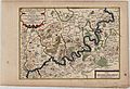
Location of Moselle in France
|
||
| Country | France | |
| Region | Grand Est | |
| Prefecture | Metz (2 arrondissements: Metz-Ville, Metz-Campagne) |
|
| Subprefectures | Boulay-Moselle Château-Salins Forbach Sarrebourg Sarreguemines Thionville (2 arrondissements: Thionville-Est, Thionville-Ouest) |
|
| Area | ||
| • Total | 6,216 km2 (2,400 sq mi) | |
| Population
(2006)
|
||
| • Total | 1,036,776 | |
| • Rank | 20th | |
| • Density | 166.792/km2 (431.99/sq mi) | |
| Time zone | UTC+1 (CET) | |
| • Summer (DST) | UTC+2 (CEST) | |
| Department number | 57 | |
| Arrondissements | 9 | |
| Cantons | 51 | |
| Communes | 730 | |
| French Land Register data, which exclude estuaries, and lakes, ponds, and glaciers larger than 1 km2 | ||

Moselle is a department in eastern France. It is named after the Moselle River.
The Moselle River flows through France, Luxembourg, and Germany. It is a major branch of the Rhine River, joining it at Koblenz. A small part of Belgium is also drained by the Moselle through its smaller rivers, the Sauer and the Our.
The Moselle River winds through one of Germany's most beautiful river valleys, especially between Trier and Koblenz. This area has been shaped by people since Roman times. Today, its hills are covered with vineyards where some of the best Riesling wines are grown. Many old castles sit on hilltops above the charming towns and villages along the river. Places like Traben-Trarbach, known for its art nouveau buildings, and Bernkastel-Kues, with its traditional market square, are popular spots for tourists.


,_2012-08_CN-01.jpg)

Contents
Understanding the Name Moselle
The name Moselle comes from the Celtic word Moseal. This became Mosella in Latin. Mosella is a smaller version of Mosa, which was the Latin name for the Meuse River. The Meuse River used to flow next to the Moselle. So, Mosella means "Little Meuse."
The Roman writer Tacitus first wrote about the Moselle in the 1st century AD. Later, in the 4th century, the Roman poet Decimius Magnus Ausonius wrote a long poem called Mosella. In his poem, he described a journey along the river to Trier. He wrote about the beautiful and rich landscapes along the Moselle valley.
The Moselle River also gave its name to two French departments: Moselle and Meurthe-et-Moselle.
Exploring Moselle's Geography

The Moselle River starts high up at 715 meters (about 2,346 feet) above sea level. Its source is on the Col de Bussang, on the western side of the Ballon d'Alsace mountains in the Vosges.
After flowing for 544 kilometers (about 338 miles), the Moselle joins the Rhine River at the Deutsches Eck in Koblenz. Here, it is only 59 meters (about 194 feet) above sea level. The river flows for 314 kilometers (about 195 miles) in France. For 39 kilometers (about 24 miles), it forms the border between Germany and Luxembourg. The remaining 208 kilometers (about 129 miles) are entirely within Germany.
The Moselle flows through the Lorraine region in France, west of the Vosges mountains. In Germany, the Moselle valley separates the Eifel and Hunsrück mountain regions.
The Moselle is the second largest river that flows into the Rhine. It carries about 328 cubic meters (about 11,583 cubic feet) of water per second. Only the Aare River carries more water into the Rhine.
Sections of the Moselle River
The Moselle River is divided into different sections:
- Upper Moselle: This part runs from where France, Germany, and Luxembourg meet, down to the Saar River near Konz.
- Middle Moselle: This section stretches from Trier to Pünderich. It is known for its wide curves, called meanders, that cut deep into the highlands. The Cochemer Krampen between Bremm and Cochem is a very famous meander.
- Lower Moselle: This section, also called the Terraced Moselle, goes from Pünderich to where it meets the Rhine in Koblenz. Both the Middle and Lower Moselle are famous for their vineyard terraces.
The Moselle River also forms the entire border between Saarland (Germany) and Luxembourg.
Moselle's River Basin
The catchment area (or river basin) of the Moselle covers a large area of 28,286 square kilometers (about 10,921 square miles).
- The French part of the basin is 15,360 square kilometers (about 5,931 square miles). This is about 54% of the total area.
- The German state of Rhineland-Palatinate has 6,980 square kilometers (about 2,695 square miles).
- Saarland (Germany) has 2,569 square kilometers (about 992 square miles).
- Luxembourg has 2,521 square kilometers (about 973 square miles).
- Wallonia (Belgium) has 767 square kilometers (about 296 square miles).
- North Rhine-Westphalia (Germany) has 88 square kilometers (about 34 square miles).
Rivers Joining the Moselle
The three largest tributaries (rivers that flow into the Moselle) are the Meurthe, the Saar, and the Sauer.
- The Meurthe used to be the main upper part of the Moselle.
- The Saar is the biggest tributary, carrying the most water (78.2 cubic meters per second) and being the longest (246 kilometers or about 153 miles).
- The Sauer is the largest tributary from the left side. It drains the area along the German-Luxembourg border.
- The Moselotte river is also very important. It carries about 40% more water than the Moselle itself at their meeting point, making it a main branch of the Moselle river system.
Tourism and Activities Along the Moselle

The Moselle valley is a popular place for tourists.
- The Moselle Wine Road and the Moselle Cycleway run through the valley. You can cycle 311 kilometers (about 193 miles) from Metz in France to Koblenz in Germany.
- Many parts of the cycleway follow old railway lines, away from busy roads.
- Every year on the Sunday after Pentecost, a 140-kilometer (about 87-mile) section of road between Schweich and Cochem is closed to cars for "Happy Moselle Day."
Many beautiful castles and ruins are located on the hills above the Moselle valley. You can see many of them on a boat trip along the river.
Hiking is also popular:
- The Moselle Ridgeway, created in 1910, offers long hiking trails on both sides of the river.
- The Calmont Trail near Ediger-Eller and Bremm goes through Europe's steepest vineyard.
- The Moselle Trail, opened in 2014, is a 365-kilometer (about 227-mile) path from Perl to Koblenz. There are also many smaller "partner trails" for hikers.
The ADAC's Rallye Deutschland car race has been held in the Moselle vineyards since 2000.
At the Koblenz Locks, the Mosellum is a visitor center. It has exhibits about fish migration in the Moselle, water life, river navigation, and how electricity is made from the river. It also has a modern fish ladder to help fish move past the locks.
Moselle Wine Region
The Moselle region is famous for its wine-growing. About 10,540 hectares (about 26,045 acres) are used for vineyards.
- Most of these vineyards, nearly 9,000 hectares, are in Germany.
- Luxembourg has about 1,300 hectares (about 3,212 acres) of vineyards.
- In France, vineyards extend into the Côtes de Moselle (130 hectares) and Côtes de Toul (110 hectares) regions.
The German Moselle wine region is officially called "Mosel." Wine experts often divide it into four main areas:
1. Upper Moselle: This area has mostly muschelkalk soil. It grows less Riesling grapes (about 10%) and more Pinot Blanc and Pinot Noir grapes. 2. Trier Region: Around the city of Trier and in the valleys of the Saar and Ruwer rivers, Riesling is the main grape. It grows on shale soils and makes up over 80% of the wine here. 3. Middle Moselle: This is the largest wine-growing area of the Moselle, with about 6,000 hectares (about 14,826 acres) of vineyards. Many experts believe the best and most famous Moselle wines come from here, especially from the steep vineyards. 4. Lower Moselle: This valley is very scenic, with medieval castles and villages with timber-framed houses. The vineyards are on steep, terraced slopes. Growing grapes here is very hard work and expensive. Because of this, some vineyards in this area are no longer used.
The wine industry along the German Moselle has been shrinking for many years. Many small, family-run wine businesses have closed. For example, in the early 1960s, there were almost 800 wine businesses in some Lower Moselle villages. By the early 2000s, there were fewer than 100. The vineyards that are no longer used are mostly on the extremely steep hillsides.
Images for kids
-
Cours from Grevenmacher to Cochem 1705
-
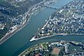
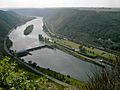
Confluence of the Moselle (right) and Rhine (left) rivers at the Deutsches Eck in Koblenz
-
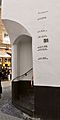
High water marks in the Old Town of Cochem
-
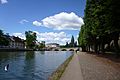
Arm of the Moselle entering the old town quarter of Metz
-
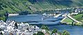
Fankel barrage
-
Lehmen Locks
-
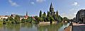
Moselle river flowing through Metz, with the church of Temple Neuf
-
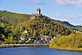
Cochem Castle, overlooking the Mosel
-
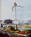
A liberty pole erected by the Moselle during the French Revolution, water colour by Goethe, 1793


See also
 In Spanish: Río Mosela para niños
