
Meurthe-et-Moselle facts for kids
Quick facts for kids
Meurthe-et-Moselle
|
||
|---|---|---|
![Prefecture]building of the Meurthe-et-Moselle department, in Nancy](/Image:Nancy_-_Pr%C3%A9fecture.JPG)
Prefecture building of the Meurthe-et-Moselle department, in Nancy
|
||
|
||

Location of Meurthe-et-Moselle in France
|
||
| Country | France | |
| Region | Grand Est | |
| Département | 7 September 1871 | |
| Prefecture | Nancy | |
| Subprefectures | Briey, Lunéville, Toul | |
| Area | ||
| • Total | 5,245.9 km2 (2,025.5 sq mi) | |
| Population
(2013)
|
||
| • Total | 731,004 | |
| • Density | 139.3477/km2 (360.909/sq mi) | |
| Time zone | UTC+1 (CET) | |
| • Summer (DST) | UTC+2 (CEST) | |
| ISO 3166 code | FR-54 | |
| Arrondissements | 4 | |
| Cantons | 23 | |
| Communes | 594 | |

Meurthe-et-Moselle is a department in the Grand Est region of France. It is named after two important rivers: the Meurthe and the Moselle. The main city and capital of Meurthe-et-Moselle is Nancy.
Contents
History of Meurthe-et-Moselle
Meurthe-et-Moselle was created in 1871. This happened after the Franco-Prussian War. It was formed from parts of the old departments of Moselle and Meurthe that remained with France.
Nancy became its capital city. The department was first divided into four main areas called arrondissements. These were Briey, Lunéville, Toul, and Nancy.
The current border between Meurthe-et-Moselle and Moselle was once the border between France and Germany. This was true from 1871 to 1919 and again from 1940 to 1944.
In 1926, the arrondissement of Toul was removed. However, it was brought back as an arrondissement in 1943.
Geography and Landscape
The Meurthe-et-Moselle department is located in the Grand Est region of France. It shares borders with four other departments, all within the same region. To the northwest, the department also borders the countries of Belgium and Luxembourg.
- Grand Est region
 |
Belgium, Luxembourg | Moselle | |
|
| Meuse | Moselle | |||
| Vosges | Bas-Rhin (a short border) |
Meurthe-et-Moselle covers an area of about 5,246 square kilometers (2,025 square miles). It stretches about 130 kilometers (81 miles) from north to south. The department's width changes from 7 kilometers (4 miles) to 103 kilometers (64 miles). It forms a narrow 'panhandle' shape in its northern part.
The highest point in the department is called the Roc de Taurupt. It is 731 meters (2,398 feet) high. This point is located between the towns of Bionville and Raon-sur-Plaine in the western part of the department.
The main rivers flowing through the department are the Meurthe and the Moselle. These two rivers are so important that the department is named after them. Other rivers found here include the Chiers and the Vezouze.
Climate in Meurthe-et-Moselle
The area around Nancy is about 217 meters (712 feet) above sea level. It has a climate where temperatures do not get too extreme. This type of climate is known as a "Marine West Coast Climate."
On average, Nancy receives about 747 millimeters (29.4 inches) of rain each year. June is usually the wettest month, with about 71 millimeters (2.8 inches) of rain. February is typically the driest month, with an average of 51 millimeters (2 inches) of rain.
The average temperature for the year in Nancy is 10°C (50°F). July is the warmest month, with an average temperature of 18.3°C (64.9°F). January is the coolest month, with an average temperature of 1.7°C (35.1°F).
| Climate data for Nancy, France | |||||||||||||
|---|---|---|---|---|---|---|---|---|---|---|---|---|---|
| Month | Jan | Feb | Mar | Apr | May | Jun | Jul | Aug | Sep | Oct | Nov | Dec | Year |
| Mean daily maximum °C (°F) | 3 (37) |
5 (41) |
10 (50) |
13 (55) |
18 (64) |
21 (70) |
23 (73) |
23 (73) |
20 (68) |
13 (55) |
7 (45) |
5 (41) |
13 (56) |
| Daily mean °C (°F) | 1 (34) |
2 (36) |
6 (43) |
8 (46) |
13 (55) |
16 (61) |
18 (64) |
18 (64) |
15 (59) |
10 (50) |
5 (41) |
3 (37) |
10 (49) |
| Mean daily minimum °C (°F) | 5 (41) |
— | −1 (30) |
1 (34) |
3 (37) |
7 (45) |
11 (52) |
13 (55) |
12 (54) |
10 (50) |
6 (43) |
2 (36) |
— |
| Average rainfall mm (inches) | 50 (2.0) |
50 (2.0) |
50 (2.0) |
50 (2.0) |
60 (2.4) |
70 (2.8) |
60 (2.4) |
60 (2.4) |
60 (2.4) |
60 (2.4) |
60 (2.4) |
60 (2.4) |
690 (27.6) |
| Source: Weatherbase.com [1] | |||||||||||||
How Meurthe-et-Moselle is Governed
Meurthe-et-Moselle is managed by the General Council of Meurthe-et-Moselle. This council is based in Nancy. The department is part of the larger Grand Est region.
Administrative Divisions
The department of Meurthe-et-Moselle is divided into several administrative areas. There are 4 arrondissements (which are like districts). It also has 23 cantons and 594 communes (which are like local towns or municipalities).
| INSEE code |
Arrondissement | Capital | Population (2013) |
Area (km²) |
Density (Inh./km²) |
Communes |
|---|---|---|---|---|---|---|
| 541 | Briey | Briey | 164,589 | 1,142.7 | 144.0 | 130 |
| 542 | Lunéville | Lunéville | 79,567 | 1,450.7 | 54.8 | 164 |
| 543 | Nancy | Nancy | 417,430 | 1,509.4 | 276.6 | 188 |
| 544 | Toul | Toul | 69,418 | 1,143.0 | 60.7 | 112 |
Here is a list of the 23 cantons in the Meurthe-et-Moselle department. These were reorganized in March 2015:
- Baccarat
- Entre Seille et Meurthe
- Grand Couronné
- Jarny
- Jarville-la-Malgrange
- Laxou
- Longwy
- Lunéville-1
- Lunéville-2
- Meine au Saintois
- Mont-Saint-Martin
- Nancy-1
- Nancy-2
- Nancy-3
- Neuves-Maisons
- Le Nord-Toulois
- Pays de Briey
- Pont-à-Mousson
- Saint-Max
- Toul
- Val de Lorraine Sud
- Vandoeuvre-lès-Nancy
- Villerupt
Population of Meurthe-et-Moselle
The people who live in the Meurthe-et-Moselle department are called Meurthois or Meurthe-et-Mosellans in French. For women, they are called Meurthoises or Meurthe-et-Mosellanes.
In 2013, Meurthe-et-Moselle had a population of 731,004 people. This means there were about 139 inhabitants per square kilometer (360 per square mile). The arrondissement of Nancy had the most people, with 417,430 inhabitants.
Economy and Jobs
The economy of Meurthe-et-Moselle used to rely heavily on mining. This was especially true until the 1960s. There were mines for iron, salt, and lime.
Today, the urban area around Nancy has a very active economy. It is mostly based on services, research, and higher education.
Related pages
Images for kids
-
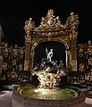
Detail of the Place Stanislas in Nancy, a UNESCO World Heritage Site
-
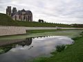
Walls and cathedral of Toul
-
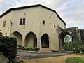
House near the château of Prény
-
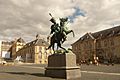
General Lasalle monument in Lunéville
-
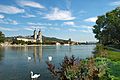
The river Moselle near Pont-à-Mousson


See also
 In Spanish: Meurthe y Mosela para niños
